
Grand Canyon Rim to Rim: North to South via North Kaibab and Bright Angel
This post may contain affiliate links, at no added expense to you should you click through and make a purchase. All pictures here are personal property of Tanya Raedeke and Melody Monberg and may not be used without permission.
Can You Still Hike the North Rim to South Rim in 2026?
Yes. The North Rim reopened May 15, 2026, and the North Kaibab to Bright Angel route is open again. The scenery is as stunning as ever. What's changed is water. North Rim services are reduced and you'll need to start more self-sufficient than in past years. If you plan for that, 2026 is still a great year to do this hike. Just note: traditional Rim-to-Rim closes October 15, 2026, so go before then.

From North Kaibab to Bright Angel Trail: the Best Grand Canyon Trail Trek
Conquer the Grand Canyon's 24-mile North Rim to South Rim route with detailed waypoint descriptions, rest stop intel, gear recommendations, and a 12-hour timeline from four experienced hikers who tackled this bucket-list adventure.
North Kaibab Trail to Bright Angel Trail
Most people believe the best hikes in the Grand Canyon go from the South Rim to the North Rim—but I’m here to change your mind. Having hiked the Grand Canyon rim to rim to rim, I can confidently say the North Kaibab Trail to Bright Angel Trail is the greatest of Grand Canyon day hikes.
Not nearly as popular as the Grand Canyon South Rim to North Rim trails, many hikers opt for a simple down-and-back route on Bright Angel Trail. But doing so means missing out on incredible beauty—winding along the Colorado River, passing through the lush oasis of Grand Canyon Indian Garden (recently renamed Havasupai Gardens), and finally climbing up through a pine-laden forest along the North Kaibab to Bright Angel Trail.
Fewer than 1% of visitors hike below the rim, making this journey an unforgettable experience.
This trek requires serious preparation and an early start, but once completed, you’ll have witnessed a level of epic beauty that few are lucky enough to see with their own eyes.
For those seeking a true Grand Canyon adventure, the North Rim to South Rim journey via the North Kaibab to Bright Angel Trail delivers unmatched scenery and an unforgettable experience.
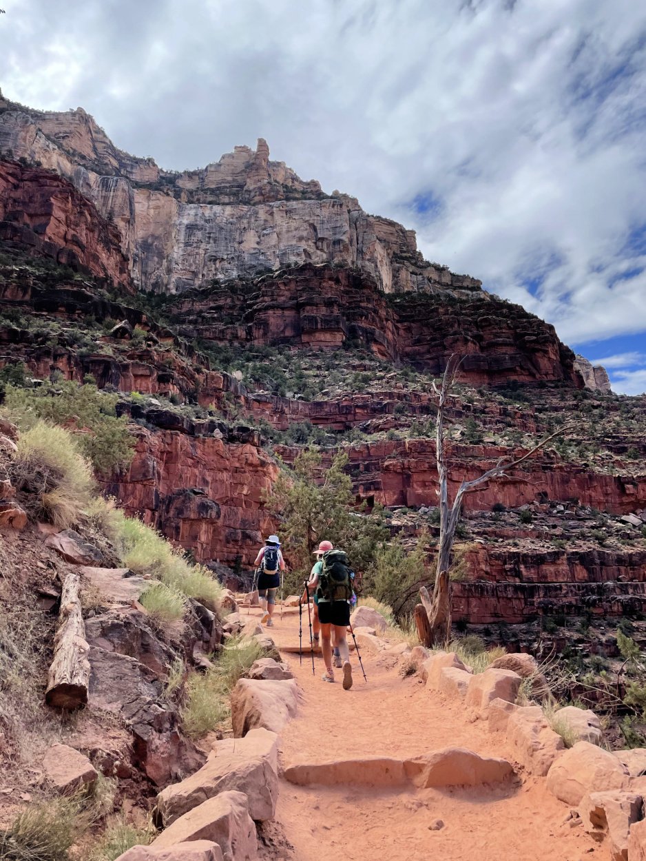
Early morning views hiking down North Kaibab Trail.
2026 Update: What North-to-South Rim Hikers Need to Know
The Grand Canyon's North Rim reopened on May 15, 2026, following the Dragon Bravo Fire and extensive trail repairs. The classic North Rim to South Rim route is possible again, but the experience is different from past years. The biggest change is water.
The route is open. The descent is the same. The water strategy is not.
Because you start at the North Rim, you begin in the most water-scarce stretch of the entire crossing. Plan your first miles as a self-supported effort.
As of the 2026 season:
All water at the North Rim is off. There is no potable water at the North Rim or the North Kaibab Trailhead.
Supai Tunnel water is off.
Manzanita Rest Area is the first reliable potable water source on the North Kaibab Trail. Note that Manzanita and several inner-canyon sources were shut off June 4–11, 2026, so always check before you go.
Bottled water (single bottles and gallon-sized) can be purchased at the North Rim General Store, open daily 9 a.m. – 4 p.m. Fill up before you drop in.
This means the descent from the North Rim to Manzanita is roughly 5 miles and more than 4,000 vertical feet with no reliable water. Carry everything you need to reach Manzanita, and treat creek water as a backup if stations are down. The Bright Angel Creek can be filtered or chemically purified at Manzanita and points south.
A few North Rim–specific hazards to plan around:
The North Kaibab Trailhead parking lot is closed June 22–26, 2026 for hazard tree mitigation. The trail stays open; park on the Highway 67 shoulder or the former lodge lot and use the Bridle Path to reach the trailhead.
The Supai Tunnel to North Kaibab Trailhead stretch runs through the burn scar. Watch for falling rock and trees, avoid hiking in high winds, expect limited shade, and move quickly.
Traditional Rim-to-Rim hiking will not be possible beginning October 15, 2026, when the North Kaibab Trail closes from the Redwall Bridge to Cottonwood Campground. If you're planning a North-to-South crossing, do it before that date.
Crews also continue work on the $208 million Transcanyon Waterline replacement project, expected to run through 2027. It's designed to reduce the frequent pipeline failures that have affected canyon water access for decades. Recent breaks have caused upheaved trail sections and water bubblers along the route.
Before your hike, always verify current trail conditions, closures, and water status with Grand Canyon National Park. Conditions change quickly due to construction, weather, and post-fire recovery.
What's closed and what's open on the North and South Rims.

Have a Plan for Your Rim to Rim Hike
We hiked across the Grand Canyon, both directions. So we did your logistics homework for you, all 52 pages worth. Full 12 Week Training Plan included - Now 30% OFF.
Hiking between the North and South Rims of the Grand Canyon is no small feat, but it's an adventure I'll never forget.
My group of four took on the rim to rim to rim over three days. Day one, South Kaibab to North Kaibab. Day two, exploring the quieter, less-crowded trails on the North Rim. Day three, North Kaibab back to Bright Angel, North Rim to South Rim.
Both long days, we started at 3:30 a.m. to give ourselves plenty of time. North Kaibab to Bright Angel is one of the best trails in the canyon, and after steady progress and a lot of breaks, we finished in just under 12 hours. Tired, but in awe.
It wasn't easy. That's what made it unforgettable. The kind of challenge that pushes you to your limits and pays you back in full.
Curious and want to know more about a Rim to Rim Grand Canyon Trail Hike?
If you are an avid hiker looking for an epic bucket list adventure, chances are you are leaning towards hiking the Grand Canyon from the South rim to North rim.
Or maybe you want to hike the Grand Canyon Rim to Rim to Rim! Say what?!
We hiked it both directions and we can show you how. Grab your 52 page Grand Canyon Hiking Guide in eBook format now.
NOTE! The most current version of our Grand Canyon Guide to download was updated February 2025.
Grand Canyon Guide Update!
We are excited to announce we added a rim to rim training plan to Hiking the Grand Canyon Rim to Rim Guide. Physical and mental preparation are key to making this a memorable hike.
Our 12-week plan outlines easy to follow daily workouts. Rather than piecemeal training, follow this simple daily rim to rim training plan (rest days included!).
Included in the plan are:
Specific exercises for stronger core, arms and legs
Cardio workouts including mileage and pack weight
Weekly hike distances
Designed for the beginner backpacker and long-distance hiker, this step-by-step plan takes the guesswork out of how to train.
We used this rim to rim training plan when we prepared to hike the Grand Canyon.
Download Our Rim to Rim Hiking Guide
Take out the guesswork and save valuable time when you grab our FULL Rim to Rim Grand Canyon hiking guide here - everything you need to know to logistically plan, train, and pack for hiking the Grand Canyon.
In this 52 page eBook guide, we will help you think and plan for this trip creatively when it comes to things like shuttles to and from the trailhead, lodging, and transportation from the Phoenix airport — plus park logistics, a 12 week training plan (NEW!) and so much more.
“I can’t tell you how valuable [this guide] was! I spent hours pouring over it, the links, your gear reviews, and it was SO helpful. I just wanted to say thanks for being a big contributor to our success.”

We trekked it two ways! Our 52 page eBook (PDF download) shows you how to prepare logistically and train for the rim to rim Grand Canyon hike in 2025, including a full 12 week training plan. RIGHT NOW IT’S 30% OFF. We show you how to hike the south rim to the north rim via the Kaibab Trails, then head back again a second day via the North Kaibab and Bright Angel Trails. Checklists and details are included for planning this epic Arizona trip. See how to train for 24 to 50 miles of hiking and up to 10,000’ in elevation changes, should you hike one or both routes. This updated Grand Canyon hiking guide covers all the nitty gritty details, plus how to pack, what to wear on the trail, how to refuel, where to sleep, and so much more for a successful rim to rim experience. Tell me more about the guide.
PLEASE DON'T ENTER HIKING THE GRAND CANYON RIM TO RIM HIKE GLIBLY.
Tell others that you’re thinking of doing this hike, hike with a friend, and have a backup plan.
No pets are allowed to go below the rim in the Grand Canyon.
WHAT’S COVERED IN THIS POST
While the South to North Hike is incredibly popular, we found delight in the less populated North to South Rim route. Hiking the Grand Canyon trail this way felt like we were in our own little world. Small bands of hikers journeyed around us but for the most part, until we hit Bright Angel Trail, this Grand Canyon hiking trail was all ours.
Along the way you'll encounter breathtaking views, desert wildlife and picturesque moments that you won't forget anytime soon.
But of course, hiking this long of a distance will have its challenges as well, such as sore feet and tiredness. (We have fond memories of blister care triage on the canyon floor.)
However, even with these hiccups in mind, the reward of experiencing this natural wonder makes it all worth it! If you're interested in taking on this challenge yourself, we can help guide you through every step of the process.
You too can hike the rim to rim Grand Canyon trail. Let us tell you how.
The Indian Garden Grand Canyon boasts about is just up from this area.
Table of Contents
North Kaibab to Bright Angel Trail Details
The Early Morning Start
Supai Tunnel
Redwall Limestone Section
Manzanita Rest Area
Cottonwood Campground
The Narrows
Phantom Ranch
Bright Angel Campground
River Resthouse
Indian Garden
Three-Mile Resthouse
Mile-and-a-Half Resthouse
South Rim Summit
What to Know Before you Go
South Rim Things to Do and Where to Stay
South Rim Day Hikes
Your eBook Guide for Training, Preparation and Logistics
North Kaibab to Bright Angel Trail Details
Grand Canyon Rim to Rim Hike Map (Public Domain from nps.gov)
Grand Canyon North Rim to South Rim Mileage
23.9 miles roundtrip (North Kaibab to Bright Angel Trail)
Elevation
10,500 feet elevation: 6,000 feet descent. 4,500 feet ascent
How to Hike Rim to Rim Grand Canyon elevation map Public domain from nps.gov
Hiking time
12 Hours
Note: Our hiking group comprised of four middle aged women in good physical shape. All had trained for several months, one member running her 7th marathon four weeks after this hike. This was the 21st time hiking the Grand Canyon rim to rim for one member.
Hiking down North Kaibab Trail to the canyon floor.
From my Personal Journal *North Rim to Bright angel trail
We started the day excited and tired. One of our party members brought a jet boil which made coffee at 2 am a godsend! The caffeine jolt was just what we needed to start our hike. (Let’s face it, it got everything moving!)
I wondered about what the toilet situation would be like on this Grand Canyon hiking trail. My marathon days were often fraught with intentional distress and I wasn’t too sure what to expect. There are options including a few long drop toilets along the canyon floor. BIFF (bathroom in forest floor) works great in some areas. However, any chance to GO before you go felt like the best option.
Having completed the Grand Canyon South Rim to North Rim hike two days before, we had an idea of what were were headed back into. Hiking the Grand Canyon North Kaibab Trail felt familiar but also daunting. No matter how you slice it, this hike is steep!

North Kaibab Trailhead - North Rim to South Rim Hike
FREEBIE! GRANd CAnyon Rim to rim hike pack list
Dusk on North Kaibab Trail headed to South Rim
Trail Start: 8,241 feet elevation
The North Kaibab Trail (Trailhead) is 1.5 miles from the Grand Canyon Lodge, located on the North Rim. We squeezed into a CRV, trekking poles, daypacks and all!
If you are camping at North Rim Campground, it’s a short 1/2 mile walk to the trailhead.
CoHH Tip! Shuttle service is available for the rim to rim hiker. Prices and times vary. There is limited parking at the TH. The Grand Canyon Lodge offers a shuttle to the trailhead.
Check their website as times vary depending on time of year.
Blurry eyed but excited to tackle this rim to rim hike the opposite direction
3:30 AM Start
While this might seem extremely early (trust us, we felt the pain), you’ll thank yourself several hours later when heading up the Bright Angel Trail exposed sections. Most of the hike is in the sun so the earlier you head out, the more “shade” you have.
CoHH TIP! We are big coffee fans around here. One of us had the foresight to bring their Jetboil and instant coffee packets. The caffeine hit at 3 am was just what we needed to get ready for our 12 hour trek.
The sun peeking through on one of the best hikes in the Grand Canyon.
North Kaibab to Bright Angel Trail
The trail head starts in the middle of a pine forest. You begin your descent winding downhill on a sandy trail. The trail is comprised of switchbacks best navigated with a very bright headlamp and hiking poles.
I, Melody, forgot to check my headlamp batteries the night before. Thank goodness Tanya had extras. Without light, this is a downright scary venture. *I invested in a rechargeable headlamp after this mishap. Best decision!
Starting early allows you to fully experience the canyon’s brilliant sunrise. For the first hour or so, you’ll be hiking down in darkness.
COHH TIP! Keep your head down to navigate the turns and steep cliffs. Portions of the North Kaibab trail have extreme drop offs, particularly in those first few miles. We found ourselves hugging the rock side during the first few miles.
As you tick off miles downhill, the sky will begin to change to a deep blue, giving you glimpses of a memorable sunrise. The light bouncing off the canyon walls is indescribable, the beauty awe inspiring.
Hiking North Kaibab Trail right after Supai Tunnel
Supai Tunnel
1.7 miles from North Rim
6,800 feet elevation
Potable Water. Pit Toilets. No Emergency Phone.
Supai Tunnel
Continue working your way down these steep switchbacks. As the sun rises, the colors of the rock stand out with brilliant hues of reds, oranges and pinks.
Walk through the narrow Supai Tunnel and keep going down.
CoHH TIP! Make sure to STOP when you are taking pictures. Many parts of this trail have extreme drop offs to one side. The trail, in some parts, are a person and half wide.
While a no brainer tip, you’d be surprised seeing how many people try to walk and shoot pics.
Redwall Limestone
Redwall Limestone Section North Kaibab Trail
Continue winding downhill towards Manzanita Rest Stop, walking through the Redwall Limestone section. This Grand Canyon hiking trail wanders through massive rock. I kept marveling at how a trail was ever carved through them. While some of the trail is in the sun, starting early gives you shade for most of this section.
CoHH SHOE TIP! Make sure you address hot spots and potential blister points BEFORE you begin this Grand Canyon through hike. You’ll be going down, down, down for 14 miles with little uphill relief. Consider going up a full size in hiking shoes to accomodate for this incessant pounding. If there are spots on your feet that tend to light up, add some moleskin and KT tape before the hike begins.
Foot check for blisters while on one of the best Grand Canyon day hikes.
In a recent Wilderness First Aid class through NOLS, the instructor kept telling us “break your feet in not your shoes.” This Grand Canyon trail proved that theory!
While good hiking shoes are a MUST, having feet already accustomed to hours in boots is the best way to ensure little to no blisters.
RELATED LINK: One of the biggest questions we get for the Grand Canyon Rim to Rim to Rim hike is, what shoes should I wear? Check out our hiking shoes post where we get down and dirty on what to look for in a hiking and backpacking shoe!
Manzanita Rest Area
5.4 miles from North Rim
4,600 feet Elevation
Potable Water. Pit Toilets. Emergency Phone. Chalkboard sign for trail notes. Picnic table. Benches.
Manzanita Rest Area North Kaibab Trail
Leave a message at Manzanita on this Grand Canyon rim to rim hike
This was our first official stop of the day’s hike. Our legs were ready for a break after that steady downhill hike. It’s easy to want to keep going, skipping rest stops. We employed a tip from my marathon training days - take breaks every hour, keeping the body rested and hydrated.
Take a moment and enjoy this rest stop. There is one picnic table and a few benches. The area is big enough to accommodate several hiking groups.
A large chalkboard was located by the bathrooms the day we were hiking the North Kaibab trail. It was fun to read people’s messages, spirited comments and high fives for a hike almost done!
One Piece of Advice? Hydrate! This might be the first time you’ve eaten since starting your hike that day. While the downhill isn’t near as taxing as the uphill, eat now. We found our bodies were not fans of food as we headed uphill. Having those calories in early helps you tackle the Bright Angel trail headed up.
Prepare your mind for the next few miles of more sun exposed downhill.
CoHH TIP! About a 1/2 mile from Cottonwood Campground you’ll have a quick uphill. It is THE BEST reprieve from all that downhill.
Soak it in as you still have more down to go. Remember, it’s 14 miles to the base of the canyon.
Cottonwood Campground
6.8 miles from North Rim
4,080 feet Elevation
Potable Water. Pit Toilets. Picnic Tables. Campground ($8 backcountry permit necessary for overnight camping). Emergency Phone. Limited bench seating.
Outskirts of Cottonwood Campground on North Kaibab Trail
A popular rest stop for many, Cottonwood Creek campground is a great place to have a quick bathroom break, fill up any empty water containers and keep trekking on. There are three toilets at this stop. When we hiked this, they needed servicing. Arm yourself with toilet paper (there was none), perhaps plug your nose and get your business done quickly.
One of the few coveted campsites at Cottonwood Creek
CoHH TIP! Bring toilet paper—many of the pit toilets on these day hikes in Grand Canyon were out. Ladies, while each toilet has a garbage can for feminine products, remember that Leave No Trace is key. Pack out what you pack in! An extra ziplock bag makes it easy to carry everything out.
If you can’t make it to the bathroom, carry a shovel and start digging. WAG bags are becoming more popular, taking a note from the Grand Canyon river boat tours. One bag should be enough for the day’s hike - pending any outrageous stomach issues.
If camping in the Grand Canyon sounds amazing to you, it does to hundreds of others as well. You must secure a backcountry permit from the park.
Nope, you cannot use the internet on this one! For all the details, head to the Grand Canyon Trust’s how to page.
Ribbon Falls
GRAND CANYON DAY HIKES TO RIBBON FALLS *if time permits
If you’re doing well on time, take the short detour to Ribbon Falls. Located about a mile and half down creek from the Cottonwood Campground, this waterfall oasis has it all: cooling water, wonderfilled views and moss covered mammoth rocks.
The bridge is no longer there so you’ll need to do fair amount of bushwhacking. While not officially marked, Ribbon Falls trail is noticeable from the North Kaibab Trail. That said, we did a fair amount of “it’s here right? Or is it that trail over there?” hollering at each other.
It’s a great early lunch spot as well as the perfect place to soak your cooling towel for the heat ahead. One of our hiking mates brought her Jetboil and made the best tasting mac and cheese. Depending on when you’ve started the hike, make this a breakfast or brunch spot.


The Narrows and Four Bridges
Hiking the Narrows on the Grand Canyon trail
As you leave Cottonwood Campground, enter the Inner Gorge, a 7.2 mile stretch of narrow canyons. The trail is not a challenge in terms of elevation. However, it can get hot quickly due to the dark black rock and trapped air flow at the canyon’s ground level.
Tanya keeping cool on this Grand Canyon rim to rim hike with her cooling towel
CoHH TIP! This is when we busted out our magic weapon - the cooling towel. A week before our taking on the best hikes in the Grand Canyon, a friend sent me a message on Instagram. She’d just done South Kaibab to Bright Angel trail and it had been hot!
Boy were we glad to have these towels! At each stop, we’d get them fully soaked with water and put them around our neck, into our shirts. As the day starting cooking, we stayed cool!
Try to avoid this area between early morning (after 8 am) to late afternoon. Imagine walking through a Las Vegas parking lot at the height of summer. Yep, it’s that hot!
There are four bridge crossings before reaching Phantom Ranch. The first two come up quickly. It seemed like forever to cross bridges 3 and 4. Don’t be discouraged with seemingly interminable distance between bridges 3 and 4.
The heat was starting to get to us by this point. Having done the South Kaibab Trail from South Rim to North Kaibab Trail hike already, we knew there was a cool treat waiting for us at Phantom Ranch.
Rejoice when you cross bridge 4, Phantom Ranch and ice cold lemonade is right around the corner!


Phantom Ranch
13.6 miles from North RiM
2,526 Feet Elevation
Overnight Lodging (reservations required). Snack shop with $5 ICE COLD lemonade ($1 refills). Potable water. Pit Latrines. Picnic Tables. Benches. Mule Mail. Emergency Phone. Ranger Station.
Small snack shop and post office at Phantom Ranch.
As you come down a small hill into Phantom Ranch, there’s a buzz of friendly chatter and hikers enjoying an extended break.
The best part? The snack shack.
If you choose to carry less water and snacks, this is YOUR place to refill. Credit card is preferred.
Our pro hiking mate, Susan, told us about the $5 lemonade before we started the hike. While pricey, it is worth EVERY SINGLE PENNY. Go ahead and get the $5 lemonade. While you’re at it, get the $1 refills. The ice alone is worth the money!


CoHH TIP! The night before the hike, fill a Owala or metal insulated water bottle with ice and put in the mini fridge. Fill it with water and more ice the morning of your hike. While the ice will most likely melt before your hike is done, the cool water will be such a treat!
Once fueled and refreshed, head towards Bright Angel Campground and trail to continue on this Grand Canyon hiking trail. Aim to be at Bright Angel Campground by 10 am to avoid the rising heat.
CoHH TIP! Bring down a few addressed and stamped postcards or letters. There is an old military green bucket with a hand stamp marking them “Mailed by a Mule from the Bottom of the Grand Canyon.”
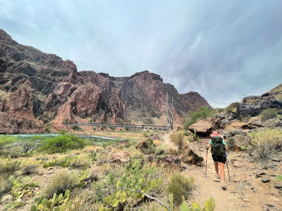
Bright Angel Campground
14 miles from North Rim
2,480 feet elevation
Potable Water. Pit Toilets. Campground (Backcountry permit required). Ranger Station nearby. Emergency Phone.
Just a few minutes walk from Phantom Ranch, look for the trail marker sign for Bright Angel Trail. Passing by a ranger station and a few cabins, continue towards the Colorado River. You’ll be heading toward what is often referred to as the Grand Canyon Indian Garden.
Stop in the middle of the bridge crossing and look around at this awe inspiring canyon. We saw a caravan of rafters heading down the Colorado River.
The Grand Canyon hiking trail map does not tell you this area is lined in sand. Layers and layers of sinking, sliding, frustrating sand makes this part particularly frustrating.
Accept the challenge.
Use trekking poles to stay upright, working that upper body. The best description I can think of for this portion is beach walking.
Melody soaking hot swollen hands in the cool stream
Framed by massive cliffs and shady with natural water sources alongside the Bright Angel Trail, you’ll see beautiful flowers, huge trees and a variety of lush green that the South Kaibab trail does not have. It is this portion of the trail that makes me declare it one of the best hikes in the Grand Canyon!
We did a few breaks along the way, soaking our heat swollen hands in the cool stream. It was heavenly.
Note! There is no potable water between Bright Angel Trail Campground and the Grand Canyon Indian Garden.


River Resthouse
8 miles from South Rim.
2,480 miles elevation
Composting toilet
Trail towards Indian Garden after River Resthouse
After plodding through a fair amount of sand, respite is ahead! Well, if you consider respite in rocky path. The River Resthouse offers a toilet (pit latrine) and new rocky terrain to traverse. The next mile of trail is over exposed sand dunes.
Spend a few minutes reapplying sunscreen, grab a few gummies and get your sunhat on. You’ll need it.
Make sure to take a quick bathroom break at the River Resthouse. You’ll have a few miles to go before the next official toilet stop. Digging a cathole or using a WAG bag is tricky along this stretch - there is very little privacy.
CoHH TIP! This is the drop off point for rafters hiking up the Canyon after rafting down. As you descend to the Resthouse, take a look below. Try to beat the rafters to the bathroom. The lines are LONG if you get caught behind the boat riders.
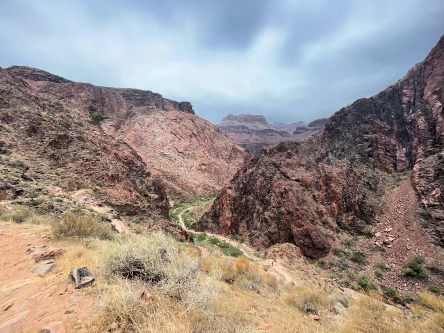
Once you pass the sand dunes, head towards the Grand Canyon Indian Garden following a creek that becomes small waterfalls in places. This portion of the Grand Canyon trail is through an area called Devil’s Corkscrew. Expect a ton of switchbacking up the sun exposed trail.
This stretch is stunning, especially as you gain altitude. The views of the canyons take over the sky with the trail etched deep into the rock. Rest often and take pictures.
It’s hot and once again, the cooling towel is your friend.


Indian Garden
4.8 miles from South Rim
3,800 Feet Elevation
Potable Water. Pit Toilets. Campground. Mule Correl.
Grand Canyon Indian Garden oasis
Probably one of the highlights of this incredible Grand Canyon hiking trail is the approach to the Indian Garden. Large cottonwood trees, roaring water over rocks and a well established campground are an oasis.
The Grand Canyon Indian Garden was used by Native Americans until 1903 when a campground was built there by Ralph Cameron (one of the early pioneers who built the Bright Angel Trail). He planted the massive cottonwood trees that dominate this area. This area is now called Havasupai Gardens in honor of the Havasupai people forced to leave their sacred lands.
If you have time (and the energy), hike the 1.5 mile side trip to Plateau Point. We didn’t have either the day we hiked this. It’s on my to do list for next time!
This is a very busy rest stop. For many, hiking to the Grand Canyon Indian Garden from South Rim via Bright Angel Trail is the perfect day hike.
Keep in mind that for most of these hikers, they are unaware of how far you’ve come, how early you got up and in some cases, lack basic trail etiquette.


Patience is key as well as a gentle “beep beep” to remind them to step aside as you hike past.
As an introvert, I found this rest stop to be startling and overwhelming. Most of our time on these Grand Canyon day hikes—except for Phantom Ranch—was spent in peaceful solitude, with long stretches where we didn’t see another soul.
CoHH TIP! From this point on, expect to be among dozens of people. Points along the trail are narrow. Step aside and allow the more energetic to pass. It’s a great way to take a break and stay safe.
Three-Mile Resthouse
3.1 miles from South Rim
4,748 Feet Elevation
Pit latrine. Potable water. Emergency phone. Regular check ins by local park rangers.
A renewed energy comes knowing you are 3 miles from the top - South Rim. This part of the hike was when stomach trouble hit for a few of our hiking members. Completely exposed to the sun, we found it hard to eat any food and keep down liquid. Take small sips of water regularly.
Grand Canyon rim to rim hiking is hard! We saw so many signs telling us “Down is option. Up is mandatory.” Humorous but also true!
The final three miles are not hard but expect a steady climb up. After logging dozens of miles with a super early start, our bodies were tired.
At each rest stop on this final bit, don’t get too ancy. Stop and cool off. There is a fair amount of shade. Take advantage of it.
Tackling the last three miles on this Grand Canyon hiking trail.
Fill up those water bottles. Soak the cooling towel. Apply more sunscreen. You’ll be switchbacking up for the last three miles of the hike.
We found using our poles as anchors was especially helpful these last miles. Much like the final miles of a marathon, this section of the Bright Angel trail is a mental game.
Mile-and-a-Half Resthouse
1.6 miles from South Rim
5,729 feet elevation
Potable water. Pit toilet. Emergency phone.
In this last stretch, expect to hike along the back of the canyon. The Grand Canyon hiking trail map is very accurate in this section. Spectacular views of the massive cliffs and varied rock colors follow you to the top.
Wind up the mountain. In some cases, expect to walk long straight and seemingly never ending stretches before switchbacking to the other side.
The last half mile of the Bright Angel trail is along a trail cut into the white limestone. It is crazy to think that this is the end of one of the best hikes in the Grand Canyon! Stop and look out at the views.
I kept pinching myself, truly amazed to think we had been on the from the other side of the Canyon that morning.
Summit at South Rim
6,860 feet elevation
Final section of the Bright Angel Trail from South Rim
Make sure you head to the Bright Angel Trailhead sign and get a picture. While your feet might be tired, your stomach in knots and your head a bit woozy, document the HUGE accomplishment of hiking North Kaibab Trail to Bright Angel trail in ONE DAY!
While you might not feel bright and perky (we can relate), make sure to memorialize the end of this incredible journey. Then head to the ice cream shop just up the hill and reward a job very well done.
We did it, conquering the north rim to south rim hike in one day!
Tips on How to Hike Rim to Rim Grand Canyon Style
*What to Know Before You Go
North Rim Opens Seasonally
The North Rim is 1,000 feet higher than the South Rim, creating seasonal winter conditions that warrant road closure and no access from October 15 - late May/early June.
Entry Fee Required
$35 entry fee for 7 day use or you can use the National Park annual pass. For $80/year, you have access to all USA national parks plus 2,000 recreational sites.
Cell Coverage
Cell coverage in the canyon is minimal at best. Expect to have no service for most or all of your hike. Consider carrying a GPS SOS device just in case. We had the Garmin inReach mini which came in handy for letting our ride know our time to the top and peace of mind for our husbands.
Water
On average, we each carried 5 liters of water. While not always the best tasting, there is potable water throughout the hike. We made sure to top off our water reservoirs and bottles at each tap.
Check the Grand Canyon site for up to date information on open water taps.
Clothing and Gear
Time of year will determine exact layers. We hiked the third week in May.
Clothing wise, each of us had shorts, hiking boots or trail running shoes, wool socks, short sleeve or tank top and long sleeve sun protection layer.
We also had a large brimmed sun hat, cooling towel (felt like built in air conditioning, especially those last few miles up), ankle length gaiters and hiking poles.
RELATED LINKS: Hiking gear is important and we love ours! Check out our full reviews on favorite Patagonia Nano puff jacket, hiking poles, rain jackets, and electrolytes.
Fueling Your Body
Aside from a well stocked day pack, we each had a hydration reservoir, 2 bottles of liquid (gatorade, 7UP), salty and sweet snacks, fresh fruit blister care and a first aid kit.
CoHH TIP! Peel a few oranges, putting the segments in your water bottle. You’ll have fresh tasting water and a later in the day snack all in one!
For quick gear check and reference, check out our Grand Canyon Rim to Rim Pack List.
Public Domain from nps.gov
South Rim
Places to Stay and things to do After Hiking The Grand Canyon Trail
South Rim is much more popular than the North Rim. Only a 90 minute drive from Flagstaff, it’s easy to access with far more amenities available.
5 Lodges (Run by Xanterra Parks)
Market Plaza near Visitor Center
Additional hotel and lodging options just outside the park
Grocery stores and Gift Shops
Ice Cream Shop with pretzels, sodas and chips as well.
Nearby Hikes and Scenic Spots


Public Domain from nps.gov
Your eBook Guide to Hiking the Grand Canyon Rim to Rim
Do not sign yourself up for hiking the Grand Canyon rim to rim if you are NOT willing to seriously train and plan. We did the homework and created a detailed guide just for you.
“My dad (64), husband and I (both 28) found your guide to hiking the Grand Canyon Rim to Rim during our 9 month training for the hike. The guide was so helpful not only in being able to prep for the day of, but also knowing how to get our bodies in canyon shape. All of us are athletic but we were not long-distance hikers before we started this training. We felt like we knew what was around every corner because of this guide and we knew how to mentally and physically get ourselves to the next rest stop.
I read EVERY blog and article on the internet about this hike, and this was by far the most thorough and complete guide to the hike. All 3 of us finished the hike in 1 day, unscathed and feeling very accomplished! Thank you to Melody and Tanya for putting in the legwork of getting this info out there for hikers like our group!”

Let’s Talk.
Got questions about this bucket list hike? Book a one hour call with us and we will answer your questions and unpack the nitty gritty logistics for hiking the Grand Canyon Rim to Rim.
our digitally savvy rim to rim Grand Canyon hiking guide covers:
Introduction and General Park Info
Getting to the Park
Personal vs. Hired Shuttles after Your Hike
Where to Stay on the South Rim
Where to Stay on the North Rim
Camping and Lodging Below the Rim
Training for the Rim to Rim to Rim Hike
5 Rim to Rim Insider Hiking Tips
What to Pack from Head to Toe
Sample Schedule and Route
Hike #1: South Kaibab to North Kaibab Trails with Waypoints
Hike #2: North Kaibab Trail to Bright Angel Trail with Waypoints
Pro Mother Hiking Tips
Rim Activities and Food
Things to Do Nearby
Rim to Rim Planning Checklist
Training Notes
Packing Checklist
Trail Map Links and Elevation Maps
Fifty-two pages of helpful planning tips and training tips for hiking the Grand Canyon, most of which is NOT covered in our separate blog posts about the two rim to rim hikes we completed. *Ebook Updated March 2024.
We trekked it two ways! Our 52 page eBook (PDF download) shows you how to prepare logistically and train for the rim to rim Grand Canyon hike in 2025, including a full 12 week training plan. RIGHT NOW IT’S 30% OFF. We show you how to hike the south rim to the north rim via the Kaibab Trails, then head back again a second day via the North Kaibab and Bright Angel Trails. Checklists and details are included for planning this epic Arizona trip. See how to train for 24 to 50 miles of hiking and up to 10,000’ in elevation changes, should you hike one or both routes. This updated Grand Canyon hiking guide covers all the nitty gritty details, plus how to pack, what to wear on the trail, how to refuel, where to sleep, and so much more for a successful rim to rim experience. Tell me more about the guide.

