
Hiking in Colorado National Parks 2025
This page contains affiliate links. If you make a purchase via a link on this page, we make a small commission at absolutely no extra charge to you. Thank you for your support of this small women-led business.

Head to these four national parks in Colorado for some of the best hiking trails in the Rocky Mountains
Diverse Colorado Parks Offer Dynamic Hikes in 2024
Did you know that of USA’s 63 national parks, there are four national parks in Colorado alone?
Rocky Mountain National Park ranks up there in the top three parks in America and offers some of the best hiking in Colorado.
Mesa Verde is one of America’s oldest parks.
Great Sand Dunes National Park and Preserve is home to a diverse ecosystem with towering sand dunes, fourteeners, and grasslands.
And finally, granite eye-candy from top to bottom, the Black Canyon of the Gunnison is worth a look-see from the top of the rim as well as along the wild Gunnison River.
The best part? You could take an epic road trip and indulge in all four of these parks. So be sure to check out the map of Colorado national parks and suggested route at the end of this post.
To wet your whistle, we share at least three hiking trails, and we also list our favorite breweries and more for after the hike.
If you are planning on visiting two or more national parks, purchase the America the Beautiful Annual Pass for $80. It lasts for one full year and covers all 63 national parks and much more, so you totally get your money’s worth. Buy it online at the USGS store or in person at any federal recreation site.
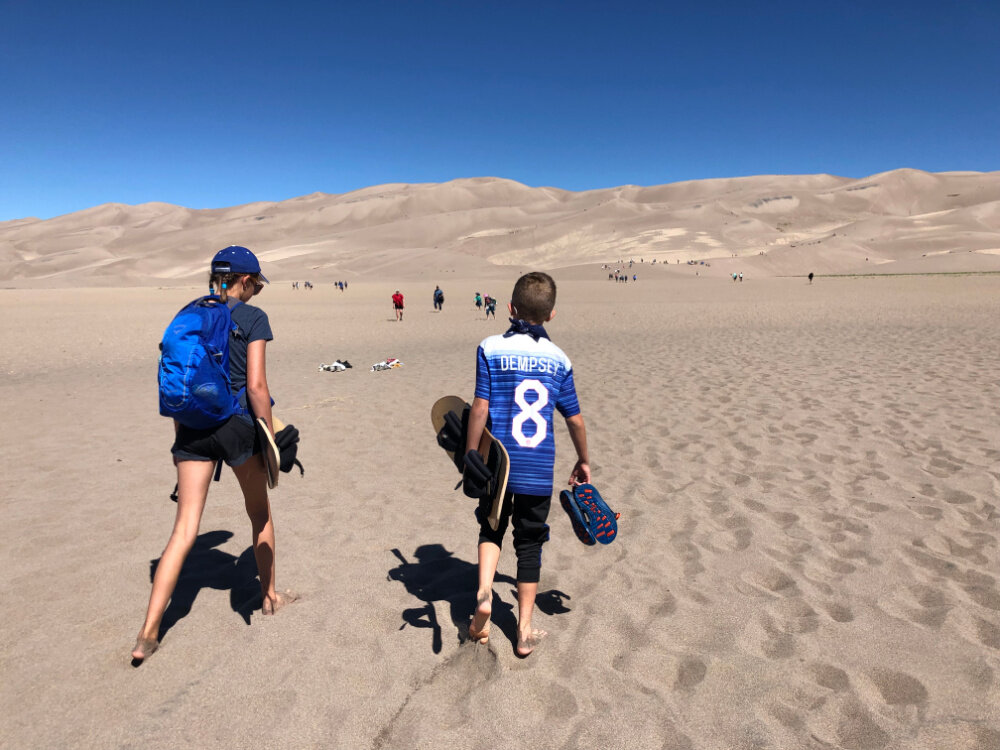
Great Sand Dunes National Park offers epic sand sledding and some of the most best hiking in Colorado
Table of Contents
Now let’s check out our dynamic four Colorado national parks! Here’s everything covered in this post. If you want to jump ahead, just tap on the subject that interests you right now and the anchor link will take you there. Or, just keep scrolling down if you want to read the entire post.

Here are our favorite pieces of hiking gear that keep us going on our adventures in all four national parks in Colorado:
We love the Osprey Sirrus Hiking Daypack for women, or the Stratos version for men, for carrying water, layers, and snacks on Colorado day hikes
2L or 3L Water Reservoir — This affordable reservoir is easy to fill
Lightweight, versatile Hiking Poles built for a full day’s send on the trail — hike longer and stronger — these are especially great for middle aged adults like me!
Sun hoodie - a must have in Colorado
Med kit
Patagonia Nano Puff jacket great for layering and 3 seasons
Be prepared for afternoon storms with the waterproof Torrentshell
What else should you pack inside your pack for a successful day hike? We’ve got your checklist of daypack essentials here.
Great Sand Dunes National Park and Preserve

The Sangre de Cristos Mountains set the backdrop for the Great Sand Dunes in Colorado
A widely diverse landscape centered around North America’s tallest sand dune, Great Sand Dunes National Park and Preserve is also home to wetlands, grassy plains, mountain forests, and alpine tundra.
The Great Sand Dunes is one of the closer national parks by Colorado Springs. If you are taking a summer vacation in Colorado Springs, it’s worth a full day trip or quick overnight.
Climbing up for sand sledding and sandboarding are the best way to conquer the dunes. Hiking trails and primitive 4X4 roads will take you up to higher escapades after you’ve tackled the dunes and dipped your feet in Medano Creek.
What mountains surround the Great Sand Dunes National Park?
Great Sand Dunes National Park is a complex geologic story. Intense volcanic activity built the San Juan mountain range to the west of the modern day dunes and tectonic activity raised the Sangre de Cristo Mountains to the north and east.
If you only have a day or two in Great Sand Dunes, the short hike to Zapata Falls and sand sledding the ginormous dunes are a must.
Hike to Zapata Falls just outside the entrance to Great Sand Dunes National Park
Zapata Falls
Trail Length: 0.9 miles Elevation Gain: 210 feet Route Type: Out & back Difficulty: Easy
Don’t miss this one of our favorite Colorado hiking trails to a box canyon waterfall, found just seven miles before you reach the Great Sand Dunes National Park entrance.
Set your GPS to Zapata Falls Recreation Area (4X4 not required - just take it slow). Park after your slow, bumpy ride and hike a quick 1/2 mile to South Zapata Creek.
If you’re up for the risk, carefully hop across the freezing cold creek up to the small box canyon where you’ll meet the 40-foot waterfall. Allow 1.5-2 hours to enjoy the hike and the falls all together. Bring your Chacos or water shoes for an easier time in the water.
Hiking to Zapata Falls in winter is a treat! Wear spikes on your way to see the frozen falls and take your time.

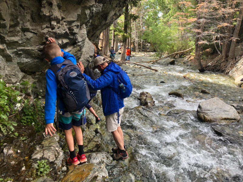
Mosca Pass Trail
Trail Length: 7 miles Elevation Gain: 700 feet Route Type: Out & back Difficulty: Moderate
This trail follows a small creek up to a meadow in the Sangre de Cristo mountains, meandering through aspens and evergreen trees.
Mosca Pass Trail is especially beautiful if you are looking for Aspens turning colors - that pure Fall Gold in Colorado. Other hikers love it in the winter.
Give yourself at least 2 hours to reach the top of the pass before heading back. ‘
American Indians and early settlers used this trail to head into the valley.

Climb to the top of these Colorado Dunes for some fantastic sand boarding or sledding
High Dune and Star Dune Loop
Trail Length: 8 miles Elevation Gain: 1309 feet Route Type: Loop Difficulty: Hard
While you can follow this hike in AllTrails, there is no direct route. You’ll aim for High Dune first, then on to Star Dune if you want to make the loop. Or turn back around if you’ve run out of gas. Cooler and easier on your body and feet in the winter. If hiking in summer, start at sunrise to avoid the heat and plan to hike in shoes so you don’t burn your feet. Pack 3 L of water and snacks. Plan on 4 - 8+ hours for the entire loop, depending how you hike it. Star Dune is North America’s tallest sand dune at 750 feet from top to bottom.
PRO TIPS: Don’t miss sand sledding down the Great Sand Dunes. In late May into early June, when snow melt trickles down through the mountains, there is water in Medano Creek before the dunes. Plan to take a dip and enjoy Colorado’s coolest temporary beach.
Hops After Your hike
Medano Pass 4WD Road If you are here in September or October during Colorado’s Gold Rush, don’t miss this 4x4 drive. Driving Medano Pass requires true 4-wheel drive. According to nps.gov, springtime creek crossings can be dangerous and the road is closed when winter conditions are hazardous. You can rent a 4WD or even take a tour with Pathfinders.
Oasis Great Sand Dunes Your one stop for gas, dining, lodging, ice cream treats, and renting sand sleds and sand boards. 7800 CO-150, Mosca, CO
The Colorado Farm Brewery This farm to glass brewery in nearby Alamosa has raving reviews.
South Fork Malt Shoppe If you’re headed to Durango after the Great Sand Dunes, this fabulous roadside burger and shake shop an hour out will hit the spot. 29956 US-160, South Fork, CO 81154
Where to Camp in the Great Sand Dunes
Don't miss out on the chance to stay at the Great Sand Dunes campsites and embark on some amazing Great Sand Dunes hikes.
Situated 180 miles from Colorado Springs, the Great Sand Dunes National Park offers year-round camping and visitation, but May and June are the most popular months to explore North America’s tallest sand dunes.
While I’ve camped at Zapata Falls Campground just before the park, Melody and her family loved camping in Pinon Flats Campground, inside the park.
Where to stay near Great Sand Dunes
Stay in this beautiful, affordable cabin near Rio Grande River. You won’t find much right by the Great Sand Dunes — you’ll be glad to be in this picturesque valley where you can enjoy fishing the Gold Medal waters.
Mesa Verde National Park
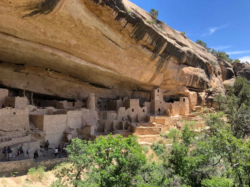
Ranger led hikes to the Cliff Palace in Mese Verde National Park in Colorado
The crown jewels of Mesa Verde National Park are summer-time ranger led tours in and through the sprawling Cliff Palace, ladder accessible Balcony House, and Long House.
These one hour tours give you a fantastic feel for how Ancient Puebloans lived here for centuries. Plan ahead to reserve tickets for these tours so you can make the most of your time exploring and hiking in a Colorado national park with unraveling history.
NOTE: You will be climbing some ladders and using steps, so access your health and balance accordingly before buying the inexpensive tour tickets.
How to Make Reservations for the Ranger Led Tours in Mesa Verde
To enter most cliff dwellings you must be on a ticketed tour with a ranger. The 2024 tour season will begin May 12.
You can reserve ranger led tours in Mesa Verde for Cliff Palace, Balcony House, and Square Tower House.
Tour tickets can be purchased only on recreation.gov or by calling 877-444-6777. Tickets are available 14 days in advance (except for as stated above), 8:00 am MST, on a rolling daily window. For example, tickets for May 14th will be available starting April 30th at 8:00 am MDT.
PRO TIP: Demand for tour tickets is high. We recommend reserving tickets as soon as they become available.

Climbing ladders in Cliff Palace makes Mesa Verde one of the coolest national parks of Colorado with kids
Cliff Palace
Trail Length: 0.4 miles Elevation Gain: 115 feet Route Type: Loop Difficulty: Easy
From about mid June to about Mid October, you can reserve your tickets ahead of time for this short Mesa Verde hike that involves steps and a couple of small ladders.
Follow the ranger’s lead and listen to his insight about this large cliff dwelling where 100 Ancient Puebloans were believed to have made their home.
With your mind’s eye, delve into Cliff Palace, what may have been an administrative and ceremonial site as well.
View Cliff Palace from the overlook located along the Cliff Palace Loop Road, typically open late-spring to December 1 -ish. Cliff Palace can also be seen from the Sun Point View and Sun Temple stops along the Mesa Top Loop Road (open year-round).
This is one of our family’s all time favorite Colorado hiking trails.
Balcony House
Trail Length: 0.4 miles Elevation Gain: 91 feet Route Type: Loop Difficulty: Easy
Reserve your tickets ahead of time for this short hike that involves 100 steps down, climbing up a rather large ladder, and then ending with a moderate ladder. Climb these ladders at your own risk; access your health and balance before you purchase your tickets for the tour. Older kids and teens love this rad cliff dwelling tour.
Is the tour unavailable? You can see the Balcony House from the Soda Canyon Overlook Trail.

Hiking the ladder from Balcony House in Mesa Verde, a Colorado national park steeped in history
Long House
Trail Length: 2.1 miles Elevation Gain: 285 feet Route Type: Out and back Difficulty: Moderate
Long House, the second largest cliff dwelling in Mesa Verde, is found in a entirely different part of the park, along the Wetherill Mesa Loop. If you just can’t get enough of ancient cliff dwellings, plan a second day for another ranger-led tour of Long House. Mesa Verde's most in-depth tour, you will need to allow over an hour to drive one way from the park’s Mesa Verde Visitor and Research Center.
You can also sign up for a backcountry experience in Mesa Verde ancient dwellings.
Wetherill Mesa, Step House, and Spruce Tree House
The Wetherill Mesa area of Mesa Verde National Park will be closed for the 2024 season to accommodate the continued construction of a new contact station in the Wetherill area.
Step House is a free, self-guided cliff dwelling. Open between spring and fall; please check Hours of Operation. The Step House trailhead is located next to the Wetherill Mesa kiosk. The one-mile trail is steep (a 100 foot descent and ascent on a winding path). There is typically a ranger on duty in the dwelling to answer questions. Allow approximately 45 minutes to visit Step House.
PRO TIP: Before or after the Cliff Palace and Balcony House tours, don’t miss the Spruce Tree Terrace, driving the Mesa Top Loop, and visiting the new Mesa Verde Visitor and Research Center near the park entrance. Binoculars are a good idea if you own them.
Spruce Tree House has been closed, due to a danger of rock fall. Visitors can view Spruce Tree House from overlooks behind the Chapin Mesa Museum in the Park Headquarters area.
Hops after your hike
WildEdge Brewing Collective Wash down some yummy pork tacos with a micro brew. 111 N Market St, Cortez, CO
Thai Cortez & Sushi For some of the best takeout and delivery in town, this place can’t be beat. Try the Pad Khing. 1430 E Main St Suite 2, Cortez, CO
Moose and More Ice Cream Shop Fantastic treats after your hiking adventures. 12 East Main St., Cortez, CO
Cortez City Park Pool A gem right in the center of the small town of Cortez, for a small entrance fee, cool off here with the kids after a long day exploring Mesa Verde National Park. 803 E Montezuma Ave, Cortez, CO
Mancos Brewing Company has some amazing craft beers and great pizza! 484 Hwy 160 E Frontage Rd, Mancos, CO
Where to stay near Mesa Verde National Park
After driving along the Dolores River from Cortez to Telluride, we say aim for a serene cabin there. Or, head for blue skies and sprawling Colorado views in this charming vacation rental near Mesa Verde. From here you are only about 45 miles from an afternoon exploring the Four Corners Monument. If Durango is next on your drive list, the Purgatory Resort is a perfect mountain spot for cooling off on hot summer days. Make sure to plan a few hours to dip in the Durango Hot Springs!
Black Canyon of the Gunnison National Park

Discover stunning hiking trails in this stunning national park of Colorado: Black Canyon of the Gunnison
The third of Colorado national parks, earning its badge in 1999, Black Canyon of the Gunnison National Park is named for its narrow dark granite cliffs rising up from the Gunnison River.
Black Canyon’s famed Painted Wall tops out at 2,250 feet tall — 1,000 feet taller than the Empire State Building. Summer visitors enjoy fishing the Gunnison and hiking along the rim.
Winter outdoor enthusiasts love Black Canyon for cross-country skiing and snowshoeing.
Camping in the Black Canyon of the Gunnison during summer is a star-studded experience, thanks to its International Dark Sky status.
Show up at the Painted Wall for sunrise or stay for a glorious sunset with your camera charged and ready to go.
Black Canyon of the Gunnison has seasonal road closures you should be aware of. The South Rim Road beyond the visitor center, The North Rim Road and East Portal Road are closed to vehicles in the winter. The roads will reopen Spring each year, once weather conditions allow.
East Portal Trail
Trail Length: 0.8 miles Elevation Gain: 19 feet Route Type: Out & Back Difficulty: Easy
A great way to see the Black Canyon of the Gunnison from the bottom up, hike a rocky trail along the river on the south rim. The East Portal sits within the Curecanti National Recreation Area, but you reach it from the south rim of Black Canyon National Park. The steep and winding road down into the canyon is part of the experience.
The trail hugs the Gunnison River tightly, so expect some rock scrambling or possibly getting a little wet. Enjoy a picnic by the river and throw in a line while you eat. There is a basic campground down here too. This is a popular area for fishermen.
PRO TIP: The East Portal is accessible from the South Rim, which is 7 miles north on CO Highway 347 from the intersection with U.S. Highway 50 east of Montrose. Turn right onto the East Portal road at the park entrance station.

Hike the East Portal Trail along the Gunnison River in Black Canyon of the Gunnison National Park
Oak Flat Loop Trail
Trail Length: 1.3 miles Elevation Gain: 311 feet Route Type: Loop Difficulty: Moderate
The Oak Flat Loop Trail is for the hiker who likes a steep challenge and wants to discover Black Canyon below the rim without going all the way to the river.
You can hike this trail year round. Bring spikes and hiking poles in winter.
If you’re hiking with young children, be aware that the trail is narrow in places and traverses some steep slopes.
Oak Flat Loop Trail begins near the Visitor Center. Head to the Oak Flat Loop sign and follow the trail to the right. Go down through a grove of aspen and then turn left to stay on the trail to the park’s wilderness.
No dogs allowed.
Cedar Point Nature Trail
Trail Length: 0.4 miles Elevation Gain: 52 feet Route Type: Out & Back Difficulty: Easy
This short, easy-going trail is lined with guideposts telling you about the various plants found in Black Canyon. At the end are two overlooks offering breathtaking views of the river over 2,000 feet below.
Here is a fabulous view of the famous Painted Wall, the tallest cliff in Colorado, as well as rock islands jutting up from the depths of the canyon. For more great views and a longer hike, head to the nearby Warner Point Nature Trail.
Pets are allowed on leash.
Gunnison Route Trail
Trail Length: 1.8 miles Elevation Gain: 1,781 feet Route Type: Out & Back Difficulty: Hard
If you’re an avid hiker not afraid of steep descents and ascents, this is your hike.
You won’t find many people on this trail. There may not be much shade until you reach the bottom and due to the strenuous hike, pack 2L of water or more, plus snacks. Take your time and allow a half day to enjoy this hike. The incredible views are worth it.
Wanna know more? The Vanimals cover the Gunnison Route Trail and show you what it’s really like.

Hops After Your hike
Rafting the Gunnison Can you raft the Gunnison River through Black Canyon of the Gunnison National Park? The short answer is no. Due to the technical nature and many challenging portages, the Gunnison is not raftable in the park. Rafting trips are available in the Gunnison Gorge National Conservation Area west of the National Park, with companies like Scenic River Tours.
Looney Bean and Coffee Trader. The perfect locally owned and locally recommended coffee shop with the best cinnamon rolls and mocha frappes around! 3480 Wolverine Dr, Montrose, CO 81401
Colorado Boy Pizzeria & Brewery Fifty feet from brewery to glass — their mission statement is “Don’t Suck”. Go for the Rustica Pizza with your beer. 320 E Main St, Montrose, CO 81401
More Fantastic Local Restaurants: Stonehouse, Camp Robber, and Pahgre’s are favorite restaurants are Montrose locals’ favorites.
Where to stay near Black Canyon of the Gunnison National Park
With Montrose and Ridgway just down the road, you can find many stunning cabins and vacation homes with sweeping views of the San Juans and quick access to outdoor adventure.
Try this incredible log cabin on Uncompahgre River on for size — just minutes from Montrose, not far from the Black Canyon of the Gunnision National Park.
Rocky Mountain National Park

Rocky Mountain National Park
Alpine lakes, snowcapped peaks, moose, elk, bears and more shape Rocky Mountain National Park (RMNP) into an iconic gateway to the west in the United States.
An All-American favorite, this national park near Denver is a local favorite as well. RMNP is a weekend destination year-round for rock climbing, horseback riding, fishing, camping, backpacking, cross-country skiing, snow-shoeing, and naturally hiking.
Drive the scenic Trail Ridge Road (U.S. 34) connecting Estes Park and Grand Lake when you visit RMNP in the summer. Winding across the Rocky Mountains, reaching its highest point at 12,183 feet elevation, Trail Ridge Road doles out jaw-dropping views, wildlife sightings (particularly at dawn and dusk), magnificent wildflowers dancing in the wind. Don’t hesitate to pull over at a pull-out for taking pictures.
Wildfires in the summer of 2020 burned 9% of the park, but already regrowth and renewal is emerging from the ashes. We’re reminded that fires are often a healthy part of the natural life of this Rocky Mountain ecosystem and help rejuvenate her forests — by even helping a wide variety of plants and animal species to thrive moving forward.
DID YOU KNOW? RMNP Timed Entry Permit Reservations are required, along with a park pass or entrance fee, to enter Rocky Mountain National Park beginning May 24, 2024. BUT, if you are visiting RMNP anytime before then, you DO NOT need a Timed Entry Permit.
Rocky Mountain National Park will implement another pilot timed entry permit reservation system during specific hours of the day, beginning on May 24 through mid-October. This system applies to all areas of the park.
There are two different timed entry permit options to choose from: Timed Entry or Timed Entry + Bear Lake Road.
There are a few key ways that the 2024 pilot timed entry permit system will be different from past years. These include:
Timed entry permit reservations for most areas of RMNP will be in place through October 14, 2024.
Timed Entry + Bear Lake Road Road permits will continue through October 20, 2024.
40 percent of available timed entry permits are released on Recreation.gov the night before a chosen arrival date. These timed entry permits will be available each day beginning at 7 p.m. MDT.
RMNP Bear Lake Trails now open after the 2020 wildfires
The Bear Lake Loop in Rocky Mountain National Park is a 30 minute drive from Estes Park and is located at the end of Bear Lake Road, 9 miles from the turn-off at Highway 36
Bear Lake Nature Trail Highly recommend taking the park and ride to Bear Lake, hike less than a mile on this nature trail, then hike down to Alberta Falls. Finally, take the shuttle back to park and ride from Glacier Gorge.
Nymph, Dream, Haiyaha, Loch, Vale Lakes Loop A magnificent 8+ mile moderate hike; however, the full loop can prove challenging. Download a map beforehand, bring bear spray, and prepare for cliff hiking and spectacular views.
Emerald Lake Make this a sunrise hike and these 3 miles will hit different. Worth the view with pretty river views along the way. Weather can change drastically.
Related Reading: Escape to the Rocky Mountains to one of these 13 destinations on the Ultimate Colorado Family Vacation — Summer 2025.
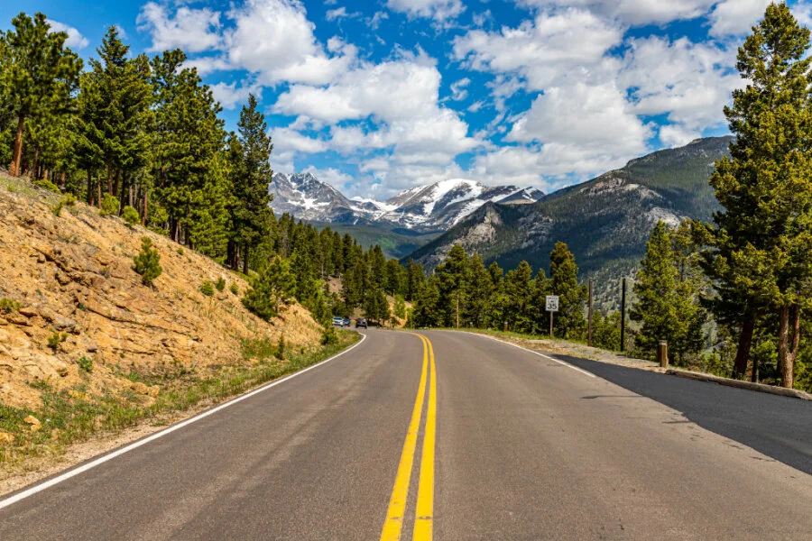
Drive Trail Ridge Road in Rocky Mountain National Park to some of the best Colorado hiking trails
Twin Owls and Lumpy Ridge Loop
Trail Length: 1.6 miles Elevation Gain: 446 feet Route Type: Loop Difficulty: Easy
This easy going hike located near Glen Haven, Colorado shows off beautiful wild flowers in the summer and is good for all hiking levels. Winter hikers love it too. Can be tacked on to Gem Lake hike.
Bear, Dream, Nymph, Emerald, Haiyaha, and Mills Lake via Glacier Gorge Loop
Trail Length: 8.2+ miles Elevation Gain: 1550’ Route: Lollipop Difficulty: Hard
Tanya just hiked this on Summer Solstice 2024 after securing a last minute campsite the night before at Glacier Basin Campground within Rocky Mountain National Park. With that secured campsite, it served as our right to drive on Bear Lake road for two days.

Emerald Lake
We hiked to six beautiful lakes on a gorgeous first summer day and ended at glorious Alberta Falls. The hike doled out unforgettable views, sweet log bridges over rushing water, pine trees for days, and so much more.
Heads Up: If you don't like hiking with a ton of people, consider starting this hike at two or three in the afternoon in the summer, but only if there are no thunderstorms looking overhead. There were less people at Lake Haiyaha and Mills Lake. We wanted to try for the Loch and Sky Pond as well, but read there was still too much snow. Next time!
The only hard part of this hike was scrambling across the boulders to get to Lake Haiyaha. Otherwise, I've done much harder hikes than this. We hiked just a bit over 8 miles and the trail never felt horribly steep. We enjoyed every minute of this hike!
Directions to the trailhead: You'll begin at the Bear Lake Trailhead which is a very popular area. The parking lot usually fills up early during the peak summer season, so we hopped on the free park shuttle just across the road from Glacier Basin Campground. Worked like a charm as the shuttles ran non-stop.

Lake Haiyaha in early summer
Sky Pond via Glacier Gorge Trail
Trail Length: 8.5 miles Elevation Gain: 1,761 feet Route Type: Out & Back Difficulty: Hard
This long, hard trail is worth the views at nearly 10,900 feet when you reach Sky Pond. You will pass Loch Lake and Lake of Glass before you reach Sky Pond. Carry plenty of water and snacks. Allow yourself a full day to tackle this hike. During winter, spikes (or crampons) may not be enough. Snowshoes and poles are recommended past Loch Lake.
For more Great RMNP hikes this summer, read Let’s Go Hiking in Rocky Mountain National Park.
And if you’re headed to RMNP in Winter, read Snowshoeing in Rocky Mountain National Park.

Hiking in Rocky Mountain National Park provides lots of Colorado trails to tackle
Hops After Your Hike
THE BARREL Unwind in their beer garden and grab some grub from the food truck after the hike. Take your pick from these Colorado brews and more: Colorado Lager, Mountain Beer, Electric Banana, and the Sad Panda Coffee Stout —- just name a few. 251 Moraine Ave, Estes Park, CO 80517
The Bistro at Marshdale For when you’re looking for something super romantic near Estes Park. 27376 Spruce Ln, Evergreen, CO 80439
Winter Park Alpine Slide Colorado’s longest alpine slide is within reach, just 35 miles south of Grand Lake. Winter Park Resort’s playground boasts exhilarating rides in winter and summer. 85 Parsenn Rd, Winter Park, CO 80482
Where to stay near Rocky Mountain National Park
One option we love is staying at YMCA of the Rockies — two locations! Stay near Grand Lake at YMCA’s Snow Mountain Ranch, or at the other end of Trail Ridge Road in YMCA’s Estes Park. So many lodging options from cabins, lodge rooms, yurts, and campsites. Plus the property amenities are WOW!
If you’re looking for a stunning, vintage cabin with big views near Estes Park, try this cabin near Rocky Mountain National Park entrance.

Staying in a yurt at YMCA’s Snow Mountain Ranch offers great access to Colorado hiking trails in Rocky Mountain National Park
Map of Colorado National Parks
So to help get your bearings of where exactly the four Colorado national parks are located, we’ve included the handy map below.
If you had at least a solid 9-10 days — TWO WEEKS would be dynamite! — you could easily drive a loop and hike amazing Colorado trails in all four national parks, with time for amazing hot springs visits in between.
The closest Colorado national park to Denver is Rocky Mountain National Park, while the Great Sand Dunes National Park and Preserve is an easy drive for a visit to Colorado national park near Colorado Springs.
Hiking in Colorado is no joke, especially if you don’t live at altitude. When visiting any national park or wilderness area, PLEASE bookmark these Colorado hiking tips and tricks so you fully savour your trip.
Suggested Road Trip Itinerary
Here’s a quick suggested road trip itinerary starting from Colorado Springs— naturally, you could drive it in reverse:
Start from Colorado Springs - so many fun things to do here!
Go hiking and sand Sledding in Great Sand Dunes National Park and Preserve
Drive the breath-taking Wolf Creek Pass to Pagosa Springs (hot springs!)
Mesa Verde National Park via Durango or Cortez
Drive the scenic Dolores River Canyon between Cortez and Telluride (consider stopover in Ouray for awesome hot springs!)
Black Canyon of the Gunnison National Park
Glenwood Springs (hot springs!)
Rocky Mountain National Park (Grand Lake entrance)
Drive Trail Ridge Road Estes Park
Denver via Boulder

Camping in Colorado - doesn’t get better than this!
Camping in Colorado National Parks
This topic deserves a post all of its own, so we wrote all about our favorite campgrounds in Colorado, plus the 11 camping essentials you need.
Here are some quick thoughts on camping in Colorado National Parks:
Reserve your camping spot as early as you can. Many national park campgrounds fill up months in advance, like Pinon Flats Campground in Great Sand Dunes National Park.
Use recreation.gov for making reservations at any of the Colorado national park campgrounds.
If you can’t get a reserved campground, find out which campgrounds have first-come, first-serve camp sites and plan to arrive on a Sunday through Friday by NOON to slip into a campsite before the weekend adventurers arrive.
If all of the reserved campsites are taken, try searching for national forest campgrounds or for privately owned campgrounds sprinkled everywhere just outside the park.
The Dyrt Pro App is worth the hype. Download it today and enjoy using the app without cell service. Never lose connection to your saved trips, lists and downloaded maps.
Our 2024 Guide to Camping in Colorado sets you up for success! 75 full pages of all our best tips and tricks.
Which of the four national parks are you most eager to explore? Do you already have an annual national park pass? Drop us a comment below — we’d love to hear from you!
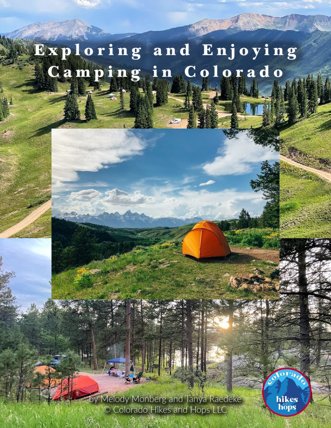
DOWNLOAD THE FULL GUIDE TO CAMPING IN COLORADO (PDF)
Together, we have over 50 years combined camping experience all over the world.
We know camping can be intimidating, especially when it comes to the right gear, finding campsites, cooking over a fire, and making sure everyone's having a blast.
Whether you're a newbie or a seasoned pro, fear not! This detailed ebook is your ultimate guide to Colorado camping. We’re spilling the beans and sharing all our best tips and tricks to make your Colorado camping trip unforgettable.
Our updated 75 full-page Exploring and Enjoying Camping in Colorado eBook (PDF) covers:
Types of Campgrounds
How to Practice Leave No Trace Principles While Camping (lnt.org/)
How to Book a Campground Online
Tips for Getting Last-Minute Campsites in Colorado
Our Favorite Campgrounds in Colorado
What To Do if you See a Bear
How to Set Up Your Entire Campsite
How to Set Up Your Camp Kitchen
11 Camping Recipes Everyone Loves
Cooking Over a Campfire
Camping Bin Checklists
Personal Camping Pack List
Things to Consider While Off the Grid / In Case of Emergency
And more!

