
Everything about the Rim to Rim Grand Canyon Hike
Is the South-to-North Rim Hike Worth Doing in 2026?
Absolutely.
This route remains one of the most spectacular hikes in North America, and many hikers will enjoy seeing the North Rim during its recovery period. The trail is open, the scenery is still incredible, and completing the climb from the Colorado River to the North Rim remains every bit as rewarding as before.
That said, hikers should arrive with more self-sufficiency than in previous years. Water access is super limited, North Rim services are reduced, and ongoing trail and infrastructure work may create occasional delays.
The route is open again. The challenge is the same. The water strategy is not.
If you're prepared for those realities, 2026 remains an excellent year to experience a Rim-to-Rim hike.

Hiking the Grand Canyon rim to rim starts before sunrise and unveils awesome views.
This post may contain affiliate links, at no added expense to you should you click through and make a purchase. All pictures here are personal property of Tanya Raedeke and Melody Monberg and may not be used without permission.
The epic Grand Canyon rim-to-rim isn’t just another hike — it’s a serious, bucket-list adventure that demands planning, hydration, training, and respect. Our guide (written in 2025) breaks down the two main routes (South Kaibab ↔ North Kaibab and North Kaibab ↔ Bright Angel*), what to pack, how to train (12-week plan), and logistical must-knows like shuttles, water, weather, and safety. Start before dawn, pack light but smart, and be ready for long miles and big elevation changes. It’s not for everyone — but with the right prep, it can be one of the most unforgettable hikes of your life. *Bright Angel Trail is closed for 2026.
2026 Update: What South-to-North Rim Hikers Need to Know
The Grand Canyon's North Rim reopened on May 15, 2026, following the Dragon Bravo Fire and extensive trail repairs. While the classic South Rim to North Rim route is once again possible, hikers should expect a different experience than in previous years.
The biggest change is water availability.
The route is open again. The challenge is the same. The water strategy is not.
As of the 2026 season:
There is currently no potable water available anywhere on the North Rim.
Supai Tunnel water is off.
Manzanita Rest Area is currently the only potable water source on the North Kaibab Trail.
Hikers finishing at the North Rim should not expect to refill water at the trailhead.
Bottled water is available for purchase at the North Rim General Store: open daily May 15, through September 7, from 9 am – 4 pm. Dry goods and bottled water are available
This means South-to-North hikers should treat the final climb out of the canyon as a largely self-supported effort. After leaving Manzanita, you'll climb approximately 5 miles and more than 4,000 vertical feet to reach the North Rim without any reliable water sources.
In addition, crews continue to work on the $208 million Transcanyon Waterline replacement project, which is expected to continue through 2027. The project is designed to reduce the frequent pipeline failures that have affected water access throughout the canyon for decades.
Before your hike, always verify current trail conditions, closures, and water status with Grand Canyon National Park, as conditions can change quickly due to construction, maintenance, weather, and post-fire recovery work.
What’s closed and what’s open on the South and North Rims.
nps.org
We Did the Rim to Rim to Rim Hike
Grand Canyon National Park’s matchless views via the Kaibab and Bright Angel Trails are one for the books.
Traversing the depths of the Grand Canyon Rim to Rim to Rim is a super rewarding bucket list experience for many passionate hikers and outdoorsy adventurers.
But let’s be real.
Do not take this long Grand Canyon hike lightly.
There are many ways to hike the Grand Canyon - you don’t have to travel far below the rim to experience her majesty in a way even more stunning than the views from the rim.
A sunrise or sunset hike, no matter the length is most definitely worth it! You will see the Grand Canyon in a way that many never will.
The Rim to Rim Grand Canyon Hike is not for everyone. In fact, many advise against it. For those willing to prepare and prepare some more, it can be done, but with a Plan B in the wings and a willingness to abandon the effort if the weather (heat!) or your body is not cooperating in the way you hoped.
NOTE: There are no services on the North Rim due to the Dragon Bravo Fire. Read current status here.
Can you hike Across the Grand Canyon in one day?
This particular post is all about our first day hiking rim to rim from south to north on the Kaibab trails.
Covering all the miles on the Rim to Rim Grand Canyon hike one way in one day is a serious task. So you should be training seriously — similar to if were about to run your very first marathon.
Approach this arduous hike with respect, wisdom, and knowledge.
For example, I am not a runner. But as an avid hiker who logged loads of miles during four months of intentional training, I donned trail runners for this challenging hike.
The time needed for hiking the Grand Canyon rim to rim varies based on one's overall conditioning, your group’s preparation, route taken, food and water breaks, and weather. On average, a Rim to Rim hike of the Grand Canyon takes about 12-15 hours to complete.
Know yourself and what you’re capable of — learn from those who have hiked the Grand Canyon before. We hiked 14+ hours our first day, from South Kaibab to North Kaibab trails.
Yes, this route is open again. The challenge is the same. But the water strategy is not.
Still leaning in?

Have a Plan for Your Rim to Rim Hike
We hiked across the Grand Canyon, both routes. Grab our 52 full-page guide including planning logistics, checklists, details about the big hike, and a full 12 week training plan. Last updated in 2025!
Hiking the Grand Canyon Rim to Rim to Rim with Trusted Companions
We were super grateful to have completed the Grand Canyon rim to rim to rim hike (yes - both ways!) via the South Kaibab, North Kaibab and Bright Angel Trails over three days time.
Way back in January, a friend who has successfully hiked the Grand Canyon — both directions — over 20 times, invited us to join her for the challenging hike at the end of May. We had four months to get training.
The plan: Hike over 23 miles from the Grand Canyon’s South Rim to North Rim via the Kaibab trails on day one, rest two nights on the North Rim, and then hike all the way back to the South Rim on day three via the North Kaibab and Bright Angel Trails. NOTE: Bright Angel Trail is not open in 2026.
Which rim of the Grand Canyon is best? That’s a great question! As one who shies away from crowds, I’d vote for the North Rim, hands down. Our full guide* reveals why.
Here in this post, I briefly cover the waypoints of our first long hike from the South Kaibab trailhead to the North Kaibab Trailhead all in one day. Our return hike, North Kaibab to Bright Angel is covered in a separate post.
Rim to Rim to Rim Planning Guide
Take out the guesswork and save valuable time when you grab our FULL Rim to Rim Grand Canyon hiking guide here — everything you need to know* to logistically plan, train, and pack for hiking the Grand Canyon. This downloadable PDF has interactive links and can be read online or printed.
*Updated and revised in 2025. This was updated before the Dragon Bravo Fire that closed down the north rim. Yes, this route is open again. The challenge is the same. But the water strategy is not!
Rim to Rim Trail from South to North
WHAT YOU DO AND DON’T NEED
You don’t need a personal Grand Canyon hiking guide to trek across the park from rim to rim. With excellent signs posted along the trail, it’s pretty difficult to get lost.
However, this bucket list hike requires months of training and planning. For this, you need a practical, helpful, informative guide to help you train and plan logistically for the hike and the trip.
We have added a full 12 week training plan to Hiking the Grand Canyon Rim to Rim, last updated in 2025! Physical and mental preparation are key to making this a memorable hike. Our 12-week plan outlines daily workouts. Rather than piece meal training, follow this simple daily plan (rest days included!).

Switchbacks along the South Kaibab Trail at sunrise
Included in the 12 week training plan are:
· Specific exercises for stronger core, arms and legs
· Cardio workouts including mileage and pack weight
· Weekly hike distances
Designed for the beginner backpacker and long-distance hiker, this step-by-step plan takes the guesswork out of how to train. We used this plan for our own Grand Canyon training and thoroughly enjoyed the hike.
“I can’t tell you how valuable [this guide] was! I spent hours pouring over it, the links, your gear reviews, and it was SO helpful. I just wanted to say thanks for being a big contributor to our success.”

We trekked it two ways! Our 52 page eBook (PDF download) shows you how to prepare logistically and train for the rim to rim Grand Canyon hike in 2025, including a full 12 week training plan. RIGHT NOW IT’S 30% OFF. We show you how to hike the south rim to the north rim via the Kaibab Trails, then head back again a second day via the North Kaibab and Bright Angel Trails. Checklists and details are included for planning this epic Arizona trip. See how to train for 24 to 50 miles of hiking and up to 10,000’ in elevation changes, should you hike one or both routes. This updated Grand Canyon hiking guide covers all the nitty gritty details, plus how to pack, what to wear on the trail, how to refuel, where to sleep, and so much more for a successful rim to rim experience. Tell me more about the guide.
Save time and take out the guesswork with our eBook (PDF) with interactive links.
In our Grand Canyon hiking guide, we help you think ahead and plan for this trip creatively when it comes to things like shuttles to and from the trailhead, lodging*, and transportation from the Phoenix airport — plus park logistics, physical training and so much more.
2026 Update: Overnight lodging is not available on the North Rim inside the park this season. The campground is there is available, but no water spigots. You can only buy water at the North Rim General Store, open from 9am to 4pm. Most hikers should arrange transportation and accommodations outside the park before their trip.
Again, please don’t enter this hike lightly. Tell others that you’re thinking of doing this hike, hike with a friend, and have a plan, and have a backup plan.
Pro Tip: Please know, no pets are allowed to go below the rim in the Grand Canyon. No dogs allowed on this hike.
WHAT’S COVERED IN THIS POST
In this article, we break down the Grand Canyon Rim to Rim hike from the South to the North Rim via the South Kaibab trailhead to the North Kaibab trailhead. Each section of the hike is unique in its own right and you’ll admire and appreciate every part of it!
TABLE OF CONTENTS:
South Kaibab to North Kaibab Trail Overview

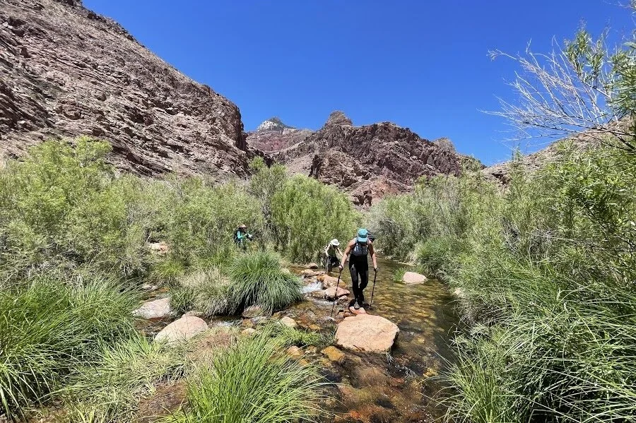
Hiking along Bright Angel Creek in Grand Canyon National Park
Distance of South Rim to North Rim
21.5 miles from the South Kaibab trailhead on the Grand Canyon’s South Rim to North Kaibab trailhead on the North Rim. Note: A quick side jaunt to Ribbon Falls adds about another 1.5 miles
Elevation Change
Get ready for 10,000 feet in elevation change! Starting at 7,200’, you will descend 4,700’ to the canyon floor before climbing back up another 5,740 to the North Rim, which sits at 8,240’. Wowza!
Hiking Time
Allow 10 - 14 Hours for hiking rim to rim, depending on your pace, number of stops, and if you take the worthy detour to Ribbon Falls. Remember, you are only as fast as your slowest hiker.
Entry Fee
A $35 entry fee is required to enter Grand Canyon National Park for 7 day use. If you plan to stay longer or visit another national park within a year, it is recommended to buy the America the Beautiful Pass. This annual pass gives you access to all national parks and 2,000 additional recreational sites.
The below graphic is a quick overview of the South to North Rim hiking routes and trails. What follows is a route overview and then a picture-filled description of the hike by signed points and rest stops along the way.

Grand Canyon Rim to Rim hiking routes - This map provided by nps.gov - public domain
South Kaibab Trailhead - An early morning start
South Rim to North Rim HIke
Starting Elevation: 7200 feet
The South Kaibab Trailhead lies west of Grand Canyon Village on the South Rim and south of Yaki Point on Yaki Point Road.
Access to this trailhead is by shuttle bus or drop off only, NO private vehicles are allowed to park here.
You’ll want to get an early morning start. Or shall we say middle of the night for some? At the end of May, we were dropped off by 4 am to begin our hike with headlamps lighting the switchbacks.
You may see a ranger at the trailhead, or you may not.
While a 4am start is early for some, it may be too late for others. You’ll be glad you began this long trek early as starting early allows you to see a gorgeous sunrise in the canyon. Also, an early start makes it more likely you’ll hike through the bottom of the canyon before it really heats up for the day.
One more bonus, an early start also allows time for a short, fantastic detour to Ribbon Falls - an ultra refreshing must-see!
PRO TIP: Do not plan on cellular service while hiking down into the Grand Canyon. Just set your phone on airplane mode if you’re using it for pictures, keeping track of time, or recording your hike.
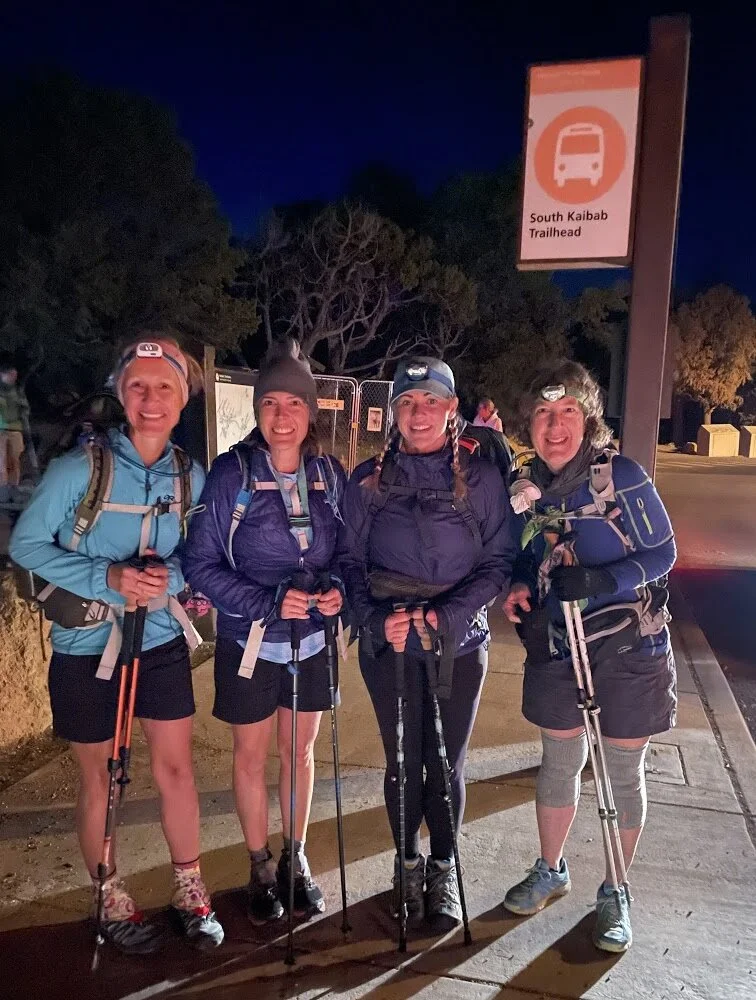
Grand Canyon rim to rim hiking starts with headlamps
DON’T FORGET LOTS OF WATER! Thankfully, water is available year-round at the trailhead from a spigot by the bus stop— but there is NO water along the trail for the first 7 miles. Plan accordingly.
Check all water availability here.
It always pays to carry too much water, versus not enough.
2026 Reminder: The route is open again. The challenge is the same. The water strategy is not.
We recommend starting your hike with 5-6 L of water in your 24 - 36 L hefty daypack.
PRO TIP: We love Osprey’s Sirrus 24L pack . I’ve been using mine for four years now, ever since hiking the rim to rim!
A common mistake is not carrying enough water or snacks. Each person in your group should be carrying water at all times.
Remember to eat as well as drink while hiking, because you will burn A LOT of calories while hiking through the Grand Canyon.
There will be mules on this trail. To avoid injury, always give way to mules and follow the directions of the mule guide. Step to the uphill side of the trail and be quiet and still until they have completely passed.
The South Kaibab Trail offers stunning views all along the trail. Consequently, it's super easy to lose track of time and distance while you hike.
It will take you at least twice as long to climb back up any distance you have descended and you will drink much more water and require lots of snacks for refueling as you do so.

The South Rim to North Rim hike leads to this view from Manzanita rest stop
In all honesty, nps.gov does not recommend hiking the canyon all in one day. It really should only be done if you plan and train for months in advance.
The difference between an awesome experience and a horrific ordeal is YOU and your choices in how you prepare.
THIS HIKE IS NO JOKE.
Trail Details
Completing the Grand Canyon Rim to Rim hike from the South Kaibab Trailhead in one day looks like this: hiking 7 miles down to the canyon floor, then hiking 14+ miles up the North Kaibab Trail to the North Rim.
The Kaibab Trails are mostly maintained, steep, and well defined dirt trails with posted signs pointing the way to the next viewpoint or rest area. You cannot get lost.
There is very little shade on trail, except while hiking along the canyon walls in the early morning or late afternoon/early evening.
Uphill hikers always have the right of way. Step aside and let them pass.
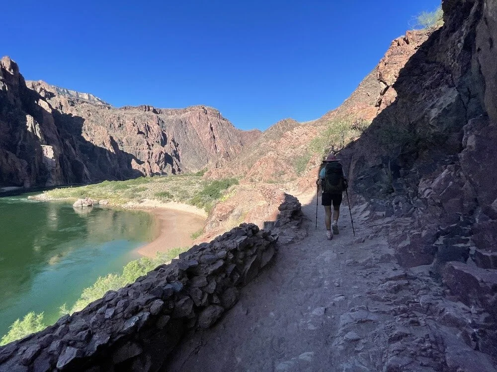
We loved walking along the Colorado River on our Grand Canyon hikes rim to rim
When is the best time to hike the Grand Canyon rim to rim?
There are multiple options for attempting a one day Rim to Rim hike in the Grand Canyon, and there are three months out of the year that are the best time to do it.
A Grand Canyon Rim to Rim hike is best done in either May, mid to late September, or in October. Typically during these months, the temperatures are not too hot in the canyon and there isn’t as much chance for flash flooding.
When we hiked at the end of May, mid-day temps in the canyon neared 90 degrees.
Temperatures often exceed 100 degrees in the bottom of the canyon from June thru August. It is generally 20-30 hotter in the canyon than up at the rim!
Note: Grand Canyon’s North Rim only offers services and road access May 15 thru October 15. During those dates, it is suggested you hike the South Kaibab Trail down then head back up the Bright Angel Trail, both on the South Rim. In winter or spring, the upper portion of trail may be extremely icy.
What are the waypoints of the South Rim to Rim Grand Canyon hike?
Finally, let’s break down the sections of the Rim to Rim hike the way we did it, starting from the South Kaibab Trailhead, through Phantom Ranch, and then up the North Kaibab Trail to the North Rim.
If you want to trek it in reverse, from the Grand Canyon North Rim to South Rim, you can hike the North Kaibab Trail to Bright Angel Trailhead. We hiked back that way, following a day of rest on the North Rim.
Yes, you can often fill up with water at Phantom Ranch when you hit the canyon floor there. Potable water spigots are typically available for hikers to refill their bottles, and beverages like water and the famous lemonade can be purchased at the Canteen's side window.
BUT, keep in mind that water availability in the inner canyon can change. The National Park Service periodically conducts pipeline maintenance or issues drinking water advisories (which may require you to filter or boil creek water). It is heavily recommended to bring a water filter in case you are getting water from the stream.

Ooh Aah Point
Ooh Aah Point
Distance
0.9 miles descending from South Kaibab Trailhead
Elevation: 6,410’
The name says it all. Ooh Aah Point is especially known for sunrise views of the Grand Canyon.
Get out your hiking poles. You will hike 790’ down switchbacks along canyon walls.
Due to beginning your rim to rim hike early (by 4am) with a headlamp, you will likely reach Ooh Point while it’s still dark or the sun is just beginning to break over the ridge. Make sure you keep your eye on the path.
Many people only hike to Ooh Aah Point — or possibly to Cedar Ridge — for a gorgeous sunrise in the morning or in the late afternoon for colorful, sprawling vistas.
Pro tip: If you want to look around or take a picture, stop first, then snap your photo. Don’t multi-task unless you’d like an injury.
NO SERVICES

Cedar Ridge
Distance
1.5 miles from South Kaibab Trailhead
Elevation: 6,080’
Insane views continue as you hike lower into the Grand Canyon. Sunrise warms up the canyon walls, revealing different hues of pink, orange, and red.
Spy the South Kaibab trail winding way below you.
Please don’t forget to drink water! While you are hiking downhill, your heart won’t be racing, but you still need to hydrate. You are burning calories without even realizing it.
Pro Tip: Use the bathroom even if don’t think you need to. There is not another toilet until the Tip Off Point.
Services: Toilets only

Cedar Ridge bathroom along South Kaibab Trail
Skeleton Point
Distance
3.0 miles down from the South Kaibab Trailhead
Elevation: 5,160’
Having stepped steeply into the canyon, you’ll be so glad you started out with hiking poles. The trail will flatten out somewhat as you near Skeleton Point.
Drink it all in and give thanks for a strong body and electrifying views.
Pro Tip: Don’t forget your sunscreen and a wide brimmed hat. Also, it might be early and it may not feel hot yet, but make yourself drink lots of water.
NO SERVICES

The Tip Off
Distance
4.4 miles down from South Kaibab Trailhead
Elevation: 3,920’
“Hiking down in the Grand Canyon is optional; hiking up is mandatory.” - gift store T-shirt
No words will ring truer at this point during your rim to rim hike.
When you reach The Tip Off, you will have stepped down over 4 miles and descended well over 3,000’ into the Grand Canyon.
From Skeleton Point to Tip Off, the trail continues very sharply with a long series of switchbacks towards the Tonto Plateau. After 1.4 miles, the South Kaibab Trail intersects the West and East Tonto trails — this is called the Tip Off (sometimes spelled Tipoff).
Pro Tip: While enjoying the view, find a large step and stretch your calf muscles off the edge for 30 seconds each. Place your hand on a hiking buddy’s shoulder to steady yourself during the stretch; return the favor.
Services: Toilets and Emergency Telephone
“My dad (64), husband and I (both 28) found your guide to hiking the Grand Canyon Rim to Rim during our 9 month training for the hike. The guide was so helpful not only in being able to prep for the day of, but also knowing how to get our bodies in canyon shape. All of us are athletic but we were not long-distance hikers before we started this training. We felt like we knew what was around every corner because of this guide and we knew how to mentally and physically get ourselves to the next rest stop.
I read EVERY blog and article on the internet about this hike, and this was by far the most thorough and complete guide to the hike. All 3 of us finished the hike in 1 day, unscathed and feeling very accomplished! Thank you to Melody and Tanya for putting in the legwork of getting this info out there for hikers like our group!”


Kaibab Suspension Bridge
The Black Suspension Bridge crosses over the Colorado River down into the canyon of Grand Canyon National Park. The bridge is 5 feet in width and spans a total length of 440 feet. This bridge is the river crossing used by mules going to and from Phantom Ranch along the South Kaibab Trail.
Fun Facts about the Colorado River:
One of the main rivers in the southwestern United States and northern Mexico.
This 1,450-mile-long river drains a large, arid watershed that includes parts of seven U.S. states and two Mexican states.
Measures 1,450 miles in length
The source is La Poudre Pass Lake, a small lake in northern Colorado’s Rocky Mountains
Empties into the Gulf of California
Runs through other popular destinations like Moab, Austin, Grand Junction, Glenwood Springs, Page and more
North Kaibab Trail Junction
Distance
6.8 miles down from South Kaibab Trailhead
Elevation: 2,500'
From the junction at the Colorado River, you have two different directions to go for a Grand Canyon Rim to Rim hike.
Option 1: You can climb back up to the South Rim via the Bright Angel Trail, which dumps you out into Grand Canyon Village. This hiking option is typically available all year round. *BRIGHT ANGEL TRAIL CLOSED IN 2026.
Option 2: Like us, continue trekking through the Grand Canyon towards Phantom Ranch and beyond, then up to the North Rim — all via the North Kaibab Trail.
WATER ALERT: In 2026, potable water on the North Kaibab Trail is severely limited due to Transcanyon Waterline construction and pipeline failures. Potable water is only consistently available at the Manzanita Rest Area (creek access/filtering is also an option here). There is no reliable potable water on the North Rim. Pack a water filter in case you are getting water from the stream.
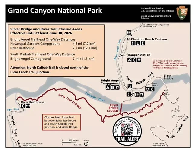
Due to the Transcanyon Waterline construction project, below is a list of current visitor use area closures for the project. Additional closures within the park may be in effect. Please check the web site Alerts section for the latest status:
Plateau Point Trail from the Tonto Trail West junction to Plateau Point: Oct. 12, 2023 - June 30, 2026
River Trail east of River Resthouse to South Kaibab Trail junction: Oct. 21, 2024- June 30, 2026
Silver Bridge: Oct. 21, 2024 - June 30, 2026
The North Rim receives only 10% of the visitors the South Rim endures. The intimate, quiet North Rim is a haven for those seeking more solitude, magnificent views, and memorable hikes.
Remember, you can only exit the North Rim typically from May 15 - October 15. Hikers either arrange for a shuttle pick-up to ride back to the south rim, or like us, choose to hike back to the South Rim.

PRO TIP: From here all the way to the North Kaibab Trailhead at the North Rim, there will be water spigots to refill your water reservoirs and water bottles. Due to random acts of erosion causing pipeline breaks, potable water stations are a GIFT and should not be solely relied upon.
IN 2026: Only Manzanita will have water.
Always have a backup water treatment plan in case spigots are not operating. We carried iodine droplets. Pack a water filter.
Check trailhead signage about water updates, etc. before hiking. From the Colorado River all the way to Roaring Springs, the trail is never far from water that can be treated or filtered should the need arise.
BUT, treated water is only available during the non-freezing season. Again, be sure to check trailhead postings or check in with the Backcountry Office before your hike, especially in early spring or late fall.
NO SERVICES

Bright Angel Campground
Distance
7.0 miles from the South Kaibab Trailhead
Elevation: 2,500'
You will reach the Bright Angel campground a 1/2 mile north of the Colorado River and find it nestled along Bright Angel Creek.
Phantom Ranch is just another 1/2 mile up the trail from this campground. If you are looking to make a longer rest stop, we recommend you keep going to Phantom Ranch, where you can indulge in refreshing lemonade.
The creek and the shade from the Cottonwood trees make Bright Angel Campground a sweet stop for cooling off if you just can’t wait another minute. You are allowed to wade in the refreshing Bright Angel Creek. You may spy deer, ringtail cats, gray foxes, and squirrels.
Pro Tip: A fee and backcountry permits are required to camp* overnight in one of the campground’s 32 sites. Check the nps.gov website for more info. Many people camp here one or two nights before hiking out to the North Rim via North Kaibab or back to the South Rim via the Bright Angel Trail.
*Our all-inclusive Grand Canyon hiking guide (updated and revised for 2025!) will cover more about different campsites and lodging ideas above and below the rim.
2026 Update: Only camping is available on the North Rim in 2026. Bring your own water.

Phantom Ranch Ranger Station
Distance:
7.1 Miles from the South Kaibab Trailhead; 13.7 Miles to the North Kaibab Trailhead on the North Rim
Elevation: 2,500’
Phantom Ranch is the perfect spot for refueling and a longer rest in the shade. You may meet mule riders here.
Sidle up to the snack bar window and order a cup of lemonade for $5; refills are just $1! A great way to hydrate! Buy snacks if you’re already low and fill up ALL of your water containers at the nearby water spigot.
The cabins were built in the 1920s. Good luck reserving one, but if you win the lottery - GO FOR IT!
Overnight stays in Phantom Ranch’s historic cabins require advanced reservations via with Grand Canyon National Park Lodges and the dormitories are currently unavailable, due to needed maintenance. As of this writing, the only way to reserve a cabin is by entering a lottery 14 months in advance.
For Phantom Ranch overnight mule rides and hiker cabin stays in April 2025 and beyond, learn about normal Phantom Ranch lottery operations.
Pro Tip: Bring postcards, stamps, addresses, and postcards. Emblazon each postcard with the red Phantom Ranch ink stamp just before inserting it in the outgoing mailbox. Your friends and family will get a kick out of receiving mail from the bottom of the Grand Canyon.
Services: Water, Toilets, Phone, Ranger Station, and Cabins/Dorms


Ribbon Falls
Distance:
13.6 miles from South Kaibab Trailhead; 7.9 miles from the North Rim’s North Kaibab Trailhead
Elevation: 3,760’
After Phantom Ranch, you will come to a sign showing the way to Ribbon Falls. You should definitely take the detour as it was a very refreshing highlight of our day!
Be sure to hike up behind the falls. Take a snack break, cool off your feet, and enjoy refueling behind the falls.
Pro Tip: There used to be a bridge that crossed over the creek to take you out from Ribbon Falls and back to the North Kaibab Trail more quickly. However, a flash flood took out the bridge, so you will cross the creek to Ribbon Falls one stepping stone at a time and then back track to the trail. Do not follow any signs to the bridge because you likely won’t find one. Bring water sandals for crossing the creek.
NO SERVICES


Cottonwood Campground
Distance
15 miles from South Kaibab Trailhead; 6.5 miles up to the North Rim along North Kaibab Trailhead
Elevation: 4,040’
A basic campground in the Grand Canyon along the North Kaibab Trail, Cottonwood is a great place for a five minute pit stop to use a toilet and fill up your water reservoirs.
There is a good chance you will hit this spot during the heat of the day.
Mostly used by backpackers, and not as heavily used as Bright Angel or Havasupai Gardens (formerly called Indian Garden) campground, Cottonwood has 11 campground sites* that are just upstream of the ranger station.
Pro Tip: If you camp here overnight, you’re now only a short 1.4 mile hike to Ribbon Falls.
*A fee and backcountry permits are required to camp here overnight. Check the nps.gov website for more info. Hit the Trail has great tips about camping at Cottonwood Campground. No Potable Water: There is no drinking water available at the campground; you must pack enough water for your trip.
Services: Toilet, Water, and Campground occasionally manned by a Ranger
Typically, treated, potable water is available from mid-May to mid-October. However, the spigots are frequently turned off due to scheduled maintenance, line breaks, or conservation measures
Check all water availability here. For example, water is off June 4-11, 2026 in several spots.

Manzanita Rest Area
Distance
16.4 miles from South Kaibab Trailhead; 5.1 miles up to the North Rim along North Kaibab Trail
Elevation: 4,400’
If you’ve made it this far, you are on the home stretch! But it’s all up from here.
Manzanita Rest Area is a shady respite with picnic tables worthy of a longer stop to refuel and use the toilet. Check the map and see how far you’ve come.
You still have 3,840 feet to climb in the next 5.1 miles.
Depending on your pace and start time, you will hopefully earn some shade from the majestic canyon walls as you continue hiking up to the North Rim.
Drink in the many different colors and hues of the canyon walls all around you: reds, oranges, yellows. Watch your step as the trail narrows along the canyon wall. Stop first before taking pictures.
Pro Tip: You will be tired. Refuel and rest here for 15-30 minutes. This stop is the perfect time for adding electrolytes to your water and gulping down energy chews. Eat whatever salty snacks you have left.
Services: Toilets, Water, Maps, and a few shade trees.
Check all water availability here. For example, water is off June 4-11, 2026 in several spots.

Manzanita Rest Area along the North Kaibab Trail
Roaring Springs Day Use Area
Distance
16.8 miles from South Kaibab Trailhead; 4.7 miles more to the North Rim along North Kaibab Trail
Elevation: 4,960’
Roaring Springs is the mouth of Bright Angel Creek, which you will follow over so much of this rim to rim hike. Look for gushing water coming straight out of the cliffs.
You will have only hiked 0.4 mile from Manzanita when you see the sign pointing down to Roaring Springs. While historic and important, we skipped a stop there since we had already detoured to Ribbon Falls and the day was getting long.
Roaring Springs is a top North Rim day hike attraction — it generously provides vital drinking water to every visitor and resident inside Grand Canyon National Park.

Grand Canyon National Park has banned selling disposable plastic water bottles since 2012. The park’s water bottle filling stations provide free, spring water all the way from Roaring Springs!
Pro Tip: If you hike the Bright Angel Trail, look for the water pipeline going across the Colorado River under the belly of the Bright Angel Trail’s Silver Bridge. That same pipeline is also buried under the North Kaibab Trail and helps deliver water from Roaring Springs to the water filling stations throughout Grand Canyon National Park.
Services: Toilets and Water* Check all water availability here. For example, water is off June 4-11, 2026 in several spots.


Redwall Bridge
Distance
18.9 miles South Kaibab Trailhead; 2.6 miles up to the North Rim along North Kaibab Trail
Elevation: 6,040’
Once you meet the Redwall Bridge, you’ll hike along more Redwall Limestone — while tough, these final miles are one of the most marvelous sections of the North Kaibab Trail.
Take time to look all around you as you plod up switchbacks cut along gigantic cliffs of Redwall Limestone. See how far you’ve come!
If you’ve hiked the Narrows in Zion National Park, this section’s canyon walls rival Zion’s beauty.
Pro Tip: You’re really gaining in altitude now, so pay attention to signs of altitude sickness. Keep drinking water and eating salty snacks. Know the signs of heat exhaustion.
NO SERVICES
Supai Tunnel
2026 Update: Supai Tunnel water is currently unavailable, and there is no potable water on the North Rim. Plan your water strategy around Manzanita Rest Area and carry enough capacity for the final climb to the rim
Distance
19.5 Miles South Kaibab Trailhead; 2.0 miles up to the North Rim along North Kaibab Trail
Elevation: 6,840’
Blasted through the red rock in the 1930s, the Supai Tunnel is iconic to the North Rim.
While many complain of too much mule poop at this point of the trail, we didn’t find it excessive nor did we meet any mules as we finished our hike. It was late afternoon / early evening as we finished our hike, so no mules were coming down.
This is your final toilet option before you reach the North Rim.
Pro Tip: Tie a bandana to your daypack. Your bandana will be handy for times you meet mules on the trail. If they kick up a lot of dust, you’ve got an instant mouth cover. The bandana also proves handy for blowing your nose on the trail.

Coconino Overlook
Distance
20.8 miles South Kaibab Trailhead; 0.7 miles up to the North Rim along North Kaibab Trail
Elevation: 7,450’
You are so close to the North Rim, you can feel it. You may experience a boost of energy knowing you are so close, or you may long for extra encouragement.
Take a quick breather at Coconino Overlook and gather one last view of the Grand Canyon and ALL of the miles you’ve crossed.
NO SERVICES
North Kaibab Trailhead at North Rim
Distance
21.5 Miles from the South Kaibab Trailhead on the South Rim; 23 miles if you traipsed over to Ribbon Falls
Elevation: 8,240’
You made it! High five everyone in your group and anyone else around!
Did you know that only 10% of Grand Canyon visitors head to the North Rim?
You’re beat. You’ll likely be hungry for anything but all the snack crumbs left in your pack. A hot shower sounds glorious and luxurious.

From the North Kaibab Trailhead, you are about another 1.8 miles to the North Rim Visitor Center and Grand Canyon Lodge and cabins. There is also a wonderful campground on the North Rim. You’re wise to plan months ahead and reserve well in advance.
Pro Tip: Download a pocket map of the North Rim before your hike and tuck it in your daypack. You’ll be tired when you emerge from the canyon and you’ll be glad for the map!
There are many short hikes to wonderful Grand Canyon viewpoints along the North Rim.
We recommend staying at least a couple of nights on the North Rim so you can explore the Grand Canyon without the crowds. The South Rim can be like Disneyland. The North Rim is quiet and relaxing.
Is the North Rim Campground open in 2026?
Yes it is open as of June 1, 2026lb Reservations can be made through www.recreation.gov.
Key details:
Water and RV hookups are not available. Campers should bring all potable water with them or plan to purchase water from the adjacent General Store operated by Aramark.
Effective as of May 15, 2026, Stage 2 fire restrictions are in effect and will remain in place throughout the duration of the 2026 season due to limited water resources.
We cover more about the North Rim things to do and places to stay in our guide to hiking the Grand Canyon Rim to Rim. Updated and revised as of March 2025, this guide includes a full 12 week training plan.

Reserve a cabin on the north rim for your Grand Canyon rim to rim hiking trip
Your Grand Canyon Hiking Guide for Rim to Rim
Do not sign yourself up for hiking the Grand Canyon rim to rim if you are NOT willing to seriously train and plan.
Save time and take out the guesswork. We created a detailed training and planning guide just for you and it was recently updated and revised in March 2025.
Our Digital Rim to Rim Grand Canyon Hiking Guide covers:
Introduction and General Park Info
Getting to the Park
Personal vs. Hired Shuttles after Your Hike
Where to Stay on the South Rim
Where to Stay on the North Rim
Camping and Lodging Below the Rim (2026 Update: Overnight cabin lodging is not available on the North Rim inside the park this season. Most hikers should arrange transportation and accommodations outside the park before their trip)
Full 12 Week Training Plan
5 Rim to Rim Insider Hiking Tips
What to Pack from Head to Toe
Sample Schedule and Route
Hike #1: South Kaibab to North Kaibab Trails with Waypoints
Hike #2: North Kaibab Trail to Bright Angel Trail with Waypoints
Pro Mother Hiking Tips
Rim Activities and Food
Things to Do Nearby
Rim to Rim Planning Checklist
Packing Checklist
Trail Map Links and Elevation Maps and MORE
Fifty-two full size pages of helpful planning tips and training tips for hiking the Grand Canyon, most of which is NOT covered in our separate blog posts about the two rim to rim hikes we completed. This guide was updated and revised in March 2025.
We trekked it two ways! Our 52 page eBook (PDF download) shows you how to prepare logistically and train for the rim to rim Grand Canyon hike in 2025, including a full 12 week training plan. RIGHT NOW IT’S 30% OFF. We show you how to hike the south rim to the north rim via the Kaibab Trails, then head back again a second day via the North Kaibab and Bright Angel Trails. Checklists and details are included for planning this epic Arizona trip. See how to train for 24 to 50 miles of hiking and up to 10,000’ in elevation changes, should you hike one or both routes. This updated Grand Canyon hiking guide covers all the nitty gritty details, plus how to pack, what to wear on the trail, how to refuel, where to sleep, and so much more for a successful rim to rim experience. Tell me more about the guide.

South Kaibab to North Kaibab Grand Canyon Rim to Rim hiking route mapped by nps.gov - public domain
