
Kenosha Pass Hikes We Love for 2026
Kenosha Pass sits on US Highway 285 southwest of Denver, reaching 10,000 feet elevation and offering access to the famous Colorado Trail. We share nine incredible hikes from easy trails like Jefferson Lake Loop and Maxwell Falls to challenging adventures like Three Mile Creek and Rolling Creek Trail through Lost Creek Wilderness. Late September through early October brings spectacular aspen colors—visit weekdays to avoid crowds. After hiking, grab craft beers at Snowpack Taproom, wine at Aspen Peak Cellars along the river, or burgers at Hungry Moose Caboose. With dispersed camping options and nearby campgrounds, Kenosha Pass offers year-round mountain adventures.

Kenosha Pass Colorado
This page contains affiliate links. If you make a purchase via a link on this page, we make a small commission at absolutely no extra charge to you.
Fall Hikes We Love Around Kenosha Pass
Yes! Fall 2026 promises fabulous aspen leaf peeping along Kenosha Pass, especially from late September into early October. Trails and road access are generally open, though some OHV areas remain gated. Always check your trail before you go.
With the right timing and a bit of planning, you'll be all set for a beautiful and memorable fall escape.
Kenosha Pass Colorado hikes offer widespread vistas, wildflowers, wildlife sightings, creek crossings, forests, aspen groves, waterfalls, lakes and a chance to hop on the famous Colorado Trail.
Driving this 10 mile long high mountain pass in the Rocky Mountains gradually takes you up to an elevation of 10,000 feet at the highest point.
The pass is part of US Hwy 285, just southwest of Denver, Colorado and northeast of the town of Fairplay, Colorado.
Other small towns nearby include Jefferson, Bailey, Conifer, and Grant, all serving as gateways to many fantastic Colorado hiking trails.
The area around Kenosha Pass in fall is well-known for its colorful groves of aspen making it a popular place for hikes and drives, especially on the weekends.
Late September through early October is peak leaf season in this part of Colorado and the Kenosha Pass trailheads can be very crowded with enthusiastic leaf-peepers and hikers.
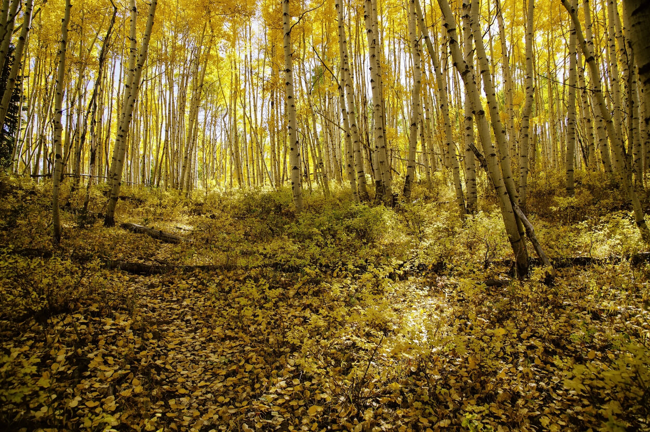
Kenosha Pass aspens are in full color late September through early October
Below we share several Kenosha Pass hikes and then we suggest a great local place to hop to after your hike for local craft beers, wine, and food. From the Aspen Peak Cellars Winery to the Hungry Moose Caboose, we’ve got something for all ages and groups.
CoHH Tip: Visit Kenosha Pass and nearby hiking trails on a week day if you prefer less people on hiking trails and on the road.
We encourage everyone to drive extra cautiously along the Highway 285 road corridor during this time. Kenosha Pass offers scenic views of South Park from a small pullout area on the south side of the pass.
Kenosha Pass and the Colorado Trail
Kenosha Pass provides access to the Colorado Trail as it heads southeast towards the Lost Creek Wilderness and west towards the Continental Divide and Jefferson Lake.
The Colorado Trail starts outside of Denver and ends in Durango. It runs lan ahejacent to the Kenosha Pass and Kenosha East Campgrounds. (U.S. Department of Agriculture)

Colorado Trail Kenosha Pass
The Colorado Trail totals 486 miles from the mouth of Waterton Canyon southwest of Denver to Durango. Coney Summit is it’s highest point at 13,271 feet.
Most of the Colorado Trail takes you hiking above 10,000 feet. Hikers pass through and restock in the towns of Breckenridge, Leadville, Buena Vista, and Silverton.
Did you know? The Colorado Trail coincides with the Continental Divide Trail for 235 miles along the Collegiate East route and 80 miles on the Collegiate West route.
Guanella Pass Scenic Byway offers fabulous hikes and is very closeby and worth your time exploring as well.
Where to stay Near Kenosha Pass
Bailey: This beautifully appointed mountain home near Bailey center sits on 1.9 acres which gives you the best of both worlds: rural and private, yet only 12 minutes to Aspen Peak Cellars Winery and Restaurant on the river.
Jefferson: Check out these top mountain cabins with views within 2 miles of Jefferson.
Conifer: Just a 9 minute drive from Staunton State Park, this mountain home in Conifer is nestled on 12 acres with a small seasonal creek running through the property.
Several great campgrounds listed are at the end of this post.

WHAT TO WEAR AND PACK FOR YOUR HIKE
How do you know what to wear and pack for Colorado hiking trails? Spend any time in Colorado and you’ll quickly learn to be prepared for any type of weather, no matter the season.
We love the Osprey Sirrus Hiking Daypack for women, or the Stratos version for men, for carrying water, layers, and snacks on Colorado day hikes
2L or 3L Water Reservoir — This affordable reservoir is easy to fill
Lightweight, versatile Hiking Poles built for a full day’s send on the trail — hike longer and stronger — these are especially great for middle aged adults like me!
Sun hoodie - a must have in Colorado
Med kit
Patagonia Nano Puff jacket great for layering and 3 seasons
Be prepared for afternoon storms with thewaterproof Torrentshell
We’ve got your full checklist of daypack essentials here.
Safety Precautions While Hiking Colorado Trails
Plan Ahead: Always tell someone know where you’re going and when you think you’ll return. Leave a note on your car seat with the information as well.
Pack Essentials: Carry plenty of water, food, warm clothing, a map, a compass, a first-aid kit, a flashlight or headlamp, and a whistle for eveyone in your group
Stay on Designated Trails: Heading out on your own can lead to getting lost and can damage the natural environment.
Check the Weather: Weather in mountainous regions can change rapidly. Make sure to check the forecast before hitting the trail and be prepared for all types of weather. Be ready to ditch your plans and choose another adventure for the day.
Know Your Limits: You know you. You know your physical limitations and when it’s time to turn around. Speak up when hiking with your friends and turn back if conditions are too challenging.
Stay Alert: Be aware of your surroundings, including wildlife, changes in the weather, trail conditions, and your own health.
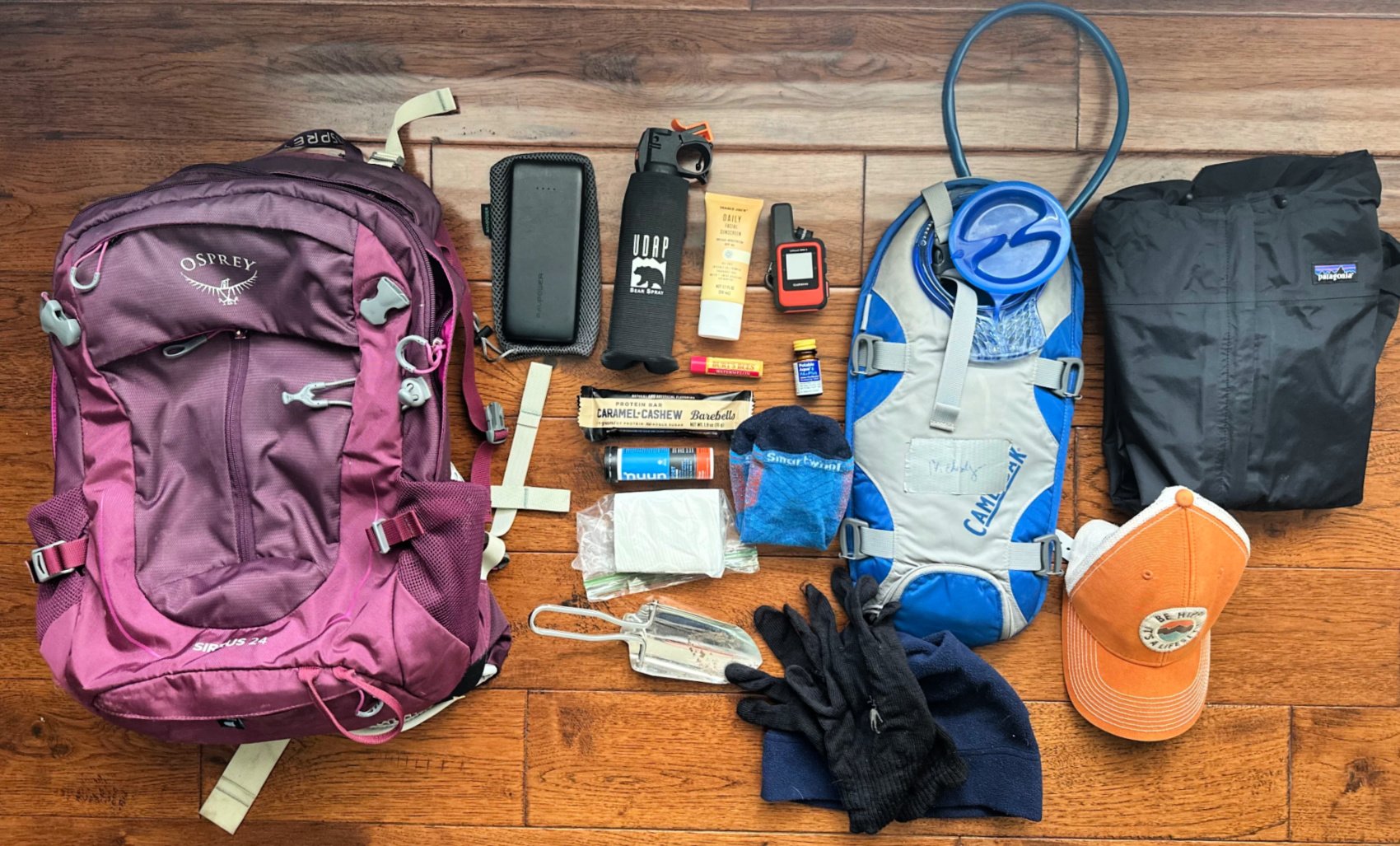
Basic Daypack Essentials for Colorado hiking trails
Easy Hikes Near Kenosha Pass in 2026
Jefferson Lake Loop
Distance: 2.4 miles Elevation gain: 78 feet Type: Loop
This kid-friendly hiking trail along Kenosha Pass hugs the shore of Jefferson Lake, a crystal clear alpine lake sitting well above 10,700 feet.
Start your hike going clockwise. This summer, the lake was high, making the shoreline difficult to navigate on the other side, causing some to turn back. This was not the case in 2023. It’s always a good idea to check out trail conditions.
Hikers recently noted that the far end of the extended loop is not maintained so rely on the All Trails map to stay on the path.
While you will navigate large rocks and a wooded area, the Jefferson Lake Loop is a fun hike for all ages.

Jefferson Lake loop is an easy hiking trail near Kenosha Pass
After your hike, pull out your paddleboards, kayaks, and fishing poles for time out on the water.
Related Reading: Best Places to Paddleboard in Colorado
Pack a picnic lunch and pack your layers in case the wind picks up.
Look up to see grand views of Glacier Peak (12,862’) and Whale Peak (13,055’).
Expect to pay a day use fee, from which you will benefit from access to picnic areas and bathrooms.
We camped at Lodgepole Campground just down the road and loved it; Aspen and Jefferson Creek campgrounds are close by as well.
How to reach the trailhead: Just 24 minutes driving from Kenosha Pass, from US Hwy 285, turn right onto Michigan Creek Rd for 2 miles. Then turn right onto Jefferson Lake Road and drive for 5.3 miles.
Hop here after your hike: Jefferson Market is part convenient store, part supplies store, and part restaurant serving up home cooked meals. A popular stop among locals, try the breakfast burrito with green chile from their full breakfast menu (7-11 am), or the green chile burger for lunch or dinner (served until 7 pm). 38600 US Hwy 285, Jefferson, Colorado
Upper Maxwell Falls Trail
Distance: 2.4 miles Elevation gain: 500 feet Type: Lollipop

Maxwell Falls Trail near Kenosha Pass
We hiked this trail counter clockwise, taking us to a lovely waterfall near the end of our hike.
You will hike along Maxwell Creek for the second half of the hike.
Signage is decent on the trails, but download a map to follow just in case.
NOTE: Pay attention for the short spur down to the waterfall, then backtrack it to follow the remaining trail back to your car.
While you are climbing some, this easy/moderate hike is not very long, making it ideal with elementary aged kids.
Keep your eyes peeled for wildlife, like moose. Keep your dogs on a leash at all times. If you stumble upon a moose, stay quiet, back up while keeping your eyes on him, and get behind a tree if it starts moving toward you aggressively. Do not provoke a moose.
While we marked this an easy trail, others might call this moderate due the elevation gain.
Best hiked in March thru October, the road leading you here has seasonal closures. Check before you go.
How to reach the trailhead: When driving from Kenosha Pass, head north on 285 Hwy, then exit onto Co Rd 73 towards Evergreen. Turn left onto Shadow Mountain Dr., then continue on Black Mountain Dr / Co Rd 78 for 5.2 miles to the trailhead.
Hop here after your hike: Snowpack Taproom and Pizzeria is the best local stop for craft beers to chase down yummy pizza, sandwiches, salad and more. September 18-20, 2023 they are hosting the Great American Beer Festival Showcase. Follow Snowpack Taproom on Instagram to see what they are up to in current time.
3 Moderate Hiking Trails Near Kenosha Pass
Gibson Lake
Distance: 7.4 miles Elevation gain: 2,055 feet Type: Out and back

The road leading to the trailhead for Gibson Lake
Looking for a moderate butt-burner? You’ll start hiking above 9,800’ and reach 11,868’ on your hike to Gibson Lake.
Your hike begins on a 4X4 road while hugging the North Fork South Platte River on your left. But, if you have a high-clearance jeep or such, you can cut off some mileage by driving further to the actual trailhead.
Once you hike above tree line, enjoy stupendous views.
This area has several aspen groves along the road and near the campgrounds, making it a wonderful place to enjoy Kenosha Pass hikes in fall.
Pack layers, as the wind may pick up above tree line.
We dispersed camped on road 60 leading up to Hall Valley. Excellent designated dispersed campsites can be found along the North Fork South Platte River.
How to reach the trailhead: From Bailey drive west on Hwy 285 for 14.3 miles. Turn right on Park County Rd 60, also known as Hall Valley Road. This road will take you past designate dispersed camping spots, Handcart campground. Just before Hall Valley Campground (5 miles in), you will bear left at the fork in the road. Watch for small wooden signs. The final 1.4 miles past Hall Valley is very rough and 4 wheel drive with high clearance is strongly recommended. Otherwise, be prepared to park earlier and hike longer.
Hop here after your hike: The Shaggy Sheep in nearby Grant, Colorado came highly recommended by a local. Serving up a small menu of Mexican inspired dishes, they also make great cocktails. Grab a mimosa and relax in the mountains, and then take a hand pie to go! NOTE: Shorter hours (7am-3pm in the summer) and they don't serve breakfast in the winter. 50455 US Hwy 285 in Grant, Colorado
West Jefferson Trail
Distance: 8.9 miles Elevation gain: 1,630 feet Type: Out and back or Loop
Day hikers and backpackers alike love this trail for the wildflowers and splendid views. Enjoy plenty of shade until the last mile or so, when you will end up hiking above tree line.
You also may meet a few mountain bikers on the trail.
When you get to the junction of Colorado Trail (CT), you can extend your mileage by going either left or right on the CT.

Wildflowers in Kenosha Pass
In fact, the West Jefferson Trail goes up to the Continental Divide and an 11-mile loop can be accomplished using the Colorado Trail (Segment 6) back down for the return trip from the Divide.
How to reach the trailhead: From US Highway 285 at Jefferson, take County Road 35 north to County Road 37. Pay the day user fee at Jefferson Lake Recreation Area and continue on the road to either Lodgepole or Jefferson Creek Campground. The trailhead starts near the first bathroom upon entering Jefferson Creek Campground.
Hop here after your hike: Stagestop Saloon is a cute spot to grab a beer and small appetizer. 53 Stagestop Rd, Jefferson, CO 80456
Or try the Hungry Moose Caboose for fresh food made to-go like local beef cheeseburgers and hot dogs, hand-cut French fries, grilled cheese, and canned soda. Find scooped ice cream, lattes, malts, and milk shakes next door. 38539 US Hwy 285, Jefferson, CO 80456
Mason Creek Loop, Bear Paw, Old Mill and Staunton Ranch Trail Loop
Distance: 8.1 miles Elevation gain: 1,391 feet Type: Loop

Plenty of hiking trails in Staunton State Park, like this one along Mason Creek
Wide mountain views, rocky crags, meadows filled with wildflowers, and aspen groves keep you in awe on this trail in Staunton State Park, just 6 miles west of Conifer, Colorado near Kenosha Pass.
This well kept multi-use trail is used by bikers, hikers, and trail riders, so be sure to know who has right of way should you intersect a different trail user.
On shared trails, horses and their riders have the highest priority, followed by hikers, and then bikers. Hikers should always yield to horses, and bikers should yield to both horses and hikers. Additionally, when hikers meet, the uphill hiker has the right of way.
However, when I notice a biker coming down a trail quickly, I move out of the way as I know it’s hard for them to put on the brakes without risking tumbling over their handlebars. If you’re not a fan of sharing a trail with mountain bikers, then perhaps choose another trail that isn’t as popular for bikers.
It’s recommended to hike this trail counter clockwise.
RELATED: We cover right-of-way in our Beginner Hiking Tips
You will find shaded sections in the forest and along the creek. If you are hiking Kenosha Pass and nearby in fall, we recommend going during the week for smaller crowds.
Fee Required: Staunton State Park charges a $10 fee to enter. Grab a map upon entry.
NOTE: As of September 2023, part of this route along the Mason Creek Trail is closed to protect nesting wildlife. Consider choosing a different trail to connect with, as many of them intersect in this part of the park. For more information, please visit the Staunton State Park website.

Kenosha Pass Colorado in fall is stunning
How to reach the trailhead: From US Hwy 285, exit on Elk Creek Rd / Shaffers Xing. Turn right onto S Elk Creek Rd. After 1.3 miles, turn right onto Staunton State Park. Pay the day pass fee and using the free map they provide, make your way to the nearby parking lot near the Mason Creek Trailhead.
Hop here after your hike: Crossroads Pub & Grill is an upbeat spot to play pool or pinball while you wait for your food. Try the Reuben with housemade Thousand Island dressing and homemade french fries. Or try the green chili, Buffalo cauliflower, or pulled pork platter. 16 Mt Evans Blvd, Pine, Colorado 80470
3 Hard Kenosha Pass Hikes
Three Mile Creek Trail
Distance: 9.4 miles Elevation gain: 2,700 feet Type: Out and back
With nearly 20 creek crossings, loads of wildflowers in summer and gorgeous aspen groves, this is also a must-do hike near Kenosha Pass in fall.

Hiking friends report this to be a new favorite hike due to the varied terrain through both wooded and wipe open spaces.
The majority of the hike is next to the creek and you’ll enjoy lots of water crossings.
Plus, new log crossings are nice, just check for slippery steps if they are wet. Be on the lookout for beaver dams.
Green and lush, you’ll love the amazing aspen groves in addition to the stream crossings. Even if you don’t have time for the full hike, it is worth it to hike a few miles out and back.
The last section of the trail is known to be steep but worth the climb for the incredible views.
How to reach the trailhead: Just 13 minutes from Kenosha Pass, head north on US Hwy 285 for 7.5 miles. Turn left on Geneva Rd / Guanella Pass Rd and find the trailhead after 2.4 miles, on the left.
Hop here after the hike: Smiling Pig Restaurant & Tavern for roadside barbecue. Try the sausage sampler, brisket, or Bison burger. To-go ordering available. 1 Co Rd 68, Bailey CO 80421
Or head a little further down the road to 285 Pete’s Pies - where the locals like to pick up their pizza too. 1 Dellwood Dr, Bailey CO 80421
NOTE: Another one of our favorite Colorado fall hikes we love is also off Guanella Pass Rd: Abyss Trail to Helms Lake. A hard, long, full-day 14+ miled hike, head there early on a week day in fall for endless views of golden aspens.
Hop on Part of Colorado Trail Segment 6 near Jefferson Lake
Segment Distance: 31.3 miles, or varies by choice Elevation gain: 4,930 feet Type: Point to Point

Hop on the Colorado Trail on Kenosha Pass
Incredibly challenging with incredible views!
Just off Kenosha Pass on Hwy 285, you can hop on part of the Colorado Trail near Jefferson Lake. While this entire segment is 31.3 miles long, we hiked just part of it from Jefferson Campground.
To access it from where we did, drive towards Jefferson Lake on FS 37, just past Lodgepole Campground and Aspen Campground.
Aspen groves welcome you in this area - hiking it in fall would be fantastic.
While you will enjoy gorgeous views, be prepared to share the trail with mountain bikers.
How to hop on the trail from the campgrounds: From Kenosha Pass, take US Hwy 285 S to Jefferson. Turn right on Michigan Creek Rd, then right onto Jefferson Lake Rd / FS 37. Drive just past Lodgepole Campground and Aspen Campground to find the trail for the Colorado Trail Segment 6.
Otherwise, to hike the entire segment point to point, start from the Colorado Trail Section #6 Trailhead on the west side of Hwy 285, just 4.3 miles north of the small town of Jefferson. Section 6 ends on CO 9 just between Breckenridge and Frisco. Naturally, you can hike all of Segment 6 or part of it.
Should you hike the entire segment, since it’s point to point, you will need to arrange to have someone pick you up at the end of your hike.
Also consider hiking Colorado Trail Segment 5 from Kenosha East Campground, starting on the east side of Hwy 285.
There is also another hiking trail nearby called Kenosha Pass to Georgia Pass and West Jefferson.

Lodgepole Campground near Kenosha Pass
Find Colorado Segment 6 on All Trails.
Hop here after the hike: Head to Salon Mexico in nearby Fairplay for drinks and delicious Mexican fare in the historic Fairplay-Valiton Hotel on Main Street. 500 Main St, Fairplay, CO 80440
Also found in Fairplay, a friend highly recommends McCall’s Park Bar, a popular watering hole with pub grub and outdoor seating in a spacious beer garden with horseshoes and river views. 511 Front St, Fairplay, CO 80440
Rolling Creek Trail via Colorado Trail
Distance: 12.9 miles Elevation gain: 3,974 feet Type: Out and back

Moose along a hiking trail near Kenosha Pass
Located near Bailey, Colorado, this hike is for those who love a good climb.
Embark on this trail for one long out-and-back day hike, or spend an overnight backpacking through the Lost Creek Wilderness.
Rock formations, shady trees, stream crossings, and wildflowers make this hard hike worth the work.
It’s reported that the first three miles are mild and smooth - making it a moderate hike for those that only want to go that far.
Miles four through six are steep with more roots and obstacles to navigate. Finding water and views are not a problem, but mosquitoes may be. Enjoy wild raspberries and blackberries in August.
Bring bug spear and bear spray, just in case.
This is a popular backpacking trail.
Permit Required: A permit is required to enter the Lost Creek Wilderness.
How to reach the trailhead: From Kenosha Pass, take US Hwy 285 N to Bailey. Turn south onto Wellington Lake Road / Co Rd 68 for a little over 7 miles until you come to the parking lot for Colorado Trail Segment 4.
COHH Tip: Wellington Lake is a great place for paddleboarding and also offers campsites. A private lake and campground, reserve day passes and overnight campground reservations to recreate on this popular lake well in advance.
Hop here after the hike: Family-owned China Village Chinese Restaurant offers amazing stir fry dishes for dine-in or take-out. 60693 US Hwy 285, Bailey CO 80421
Brookside McCurdy Trail
Distance: 14.7 miles Elevation gain: 3,435 feet Type: Out and back
For a challenging all-day endeavor, this is a fantastic one near Kenosha Pass hikes in both fall and winter. Bring micros spikes in the winter.
The Brookside McCurdy Trail cuts through the middle of the Lost Creek Wilderness. You may see backpackers on this trail in summer.
Terrain varies and includes beautiful meadows, forest, wide open spaces (that may be hot on a summer mid-day), and red rock formations.
Enjoy views of Mount Blue Sky, standing tall at 14,265. This is the highest peak in the Mount Evans Wilderness in the Front Range of Colorado’s Rocky Mountains.
Expect some creek crossings as you climb up, up, up to above 11,200 feet.
Keep your eyes peeled for moose.
How to reach the trailhead: Drive to Bailey Colorado on US Hwy 28. Turn onto Co Rd 64A (after passing South Park Coney Island Boardwalk), then turn right on Co Rd 64 to drive to the Brookside-McCurdy Trailhead.
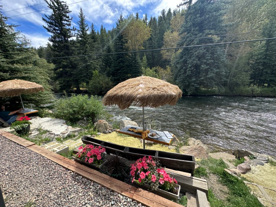
Aspen Peak Cellars sits right on the North Fork South Platte River
Hop here after your hike: Aspen Peak Cellars Winery is a lovely restaurant with indoor and outdoor seating right on the North Fork South Platte River. Local wine paired with shareable charcuterie boards, plus scrumptious made-from scratch entrees served in a family atmosphere with European flavor. We loved it so much, we dined there three times in one weekend! 60750 US Hwy 285, Bailey CO 80421
Camping near Kenosha Pass
Here are some wonderful spots for camping near Kenosha Pass hikes that we love:
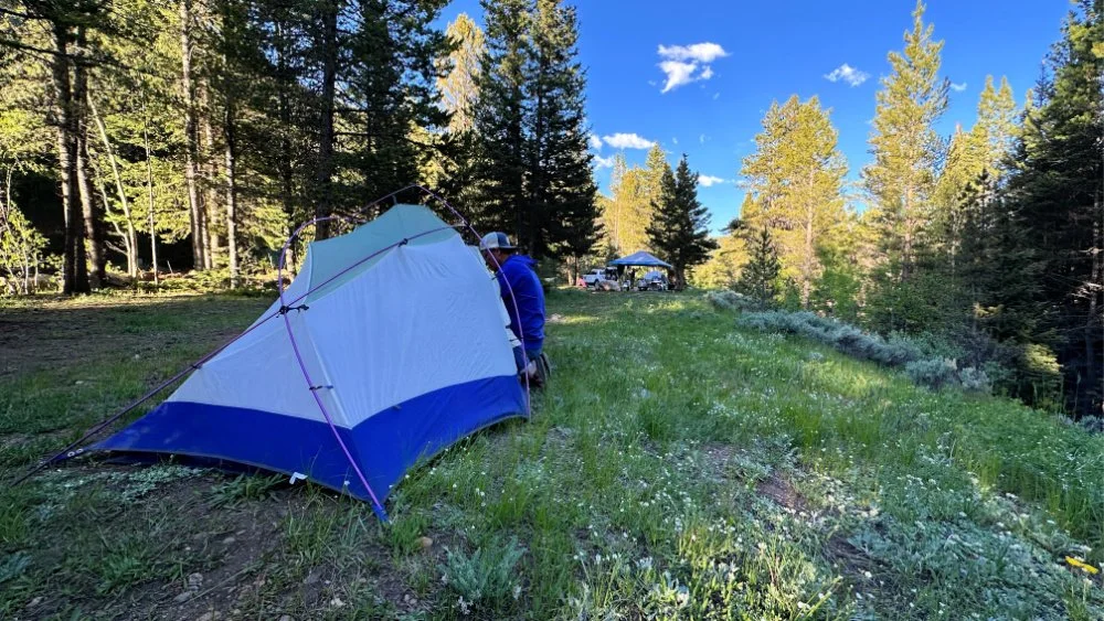
Dispersed camping along Park Co Rd 60, which hugs the North Fork South Platte River
Kenosha Pass Campground
Camping off Kenosha pass 285 N/ right from Jefferson
Dispersed Camping on Park County Rd 60, just before Handcart Campground.
Handcart Campground on Park County Rd 60, hugging the North Fork South Platte River.
Hall Valley Campground on Park County Rd 60, also hugging the North Fork South Platte River.
Find more great dispersed camping just after Hall Valley Campground.
Timberline Campground off of Park County Road 58.
Wellington Lake offers a popular private campground. Make reservations here.
Staunton State Park
Guanella Pass Scenic Byway offers fabulous hikes and campgrounds too. It is very close to Kenosha Pass and worth your time exploring as well.
Ultimate Guide to Camping in Colorado
Our 75 full page Ultimate Guide to Camping in Colorado (PDF download) covers the following 23 items with practical checklists and how-tos:
What You Should Know About Camping in Colorado:
Types of Camping in Colorado
Three Types of Campgrounds
When You’d Rather Sleep Off the Ground
Practicing Leave No Trace
What to Do if You See a Bear, Bear Awareness and Safety Tips
Quick Tips for Camping

Where to Camp in Colorado:
How to Book a Campground
Apps to Upgrade Your Camping Game
Our Favorite Scenic Campgrounds with Nearby Hikes
Campsite Set Up and Camp Meals:
Setting up Your Campsite
Setting Up Your Camp Kitchen for Success
Additional Gear Needed for Dispersed Camping
Favorite Camping Recipes - Breakfast, Lunch, Dinner
How to Build a Proper Campfire
Cooking Over a Campfire
Camp Coffee Tips
Extras:
Camping Gear Essential Checklist
Camp Bin Checklists
In Case of Emergency & Plan B
Your Personal Packlist
Know the Signs of Altitude Sickness
Building and Putting Out Campfires
DIY First Aid Medical Kit