
Manitou Incline Hike: Your 2026 Guide
Conquer Colorado's most challenging stair climb! Learn everything you need to tackle the Manitou Incline's 2,744 steps with tips on parking, pacing, gear, and more.
Your body was made to conquer.
Learn How To Prepare For A Hike Up the Manitou Springs Incline in 2026
Are you ready for the ultimate challenge? Conquer the Manitou Incline in Colorado, one of the most demanding trails in the state.
This guide will give you all the essential tips and tricks on how to make it to the top, enjoy incredible views, and have an adrenaline-filled experience!
This Colorado Springs incline hike has marked steps.
Plus, learn about two nearby Colorado stair hikes as training opportunities to conquer the quintessential incline Colorado boasts about.
Before attempting the Manitou Incline, make sure you take time to understand this challenging trail.
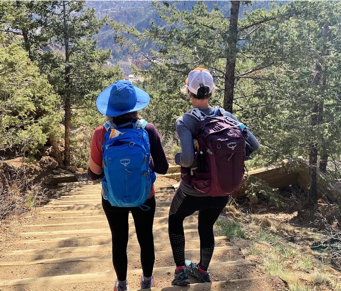
Known for its intense climb, the Manitou Incline elevation gain is nearly 2,000 feet, making this steep, stair-like path near Manitou Springs a favorite for fitness enthusiasts and adventure seekers alike!
Looking for Manitou Incline tips? Start by pacing yourself, especially if you’re a first-timer.
Wear sturdy shoes with good grip, bring plenty of water, and plan your hike early in the day to avoid crowds and heat.
It’s essential to know what kind of terrain and obstacles you can expect along the way.
One of the best Manitou Incline tips? Check out detailed trail descriptions and find out how long does the Manitou Incline take before you head out, so you’re ready for the challenge ahead.
Where is the Manitou Incline?
Built on the side of Pikes Peak, this 900 foot extreme outdoor workout attracts Olympians, ultrarunners, the athletic tourist and adventure hiker, making the Manitou Incline one of Colorado Springs premier challenge hikes.
This famous, or should we say infamous stairs in Colorado Springs are ranked as one of Colorado’s hardest hikes, located minutes from Manitou Springs breweries and restaurants. *Technically the Colorado incline is in Manitou Springs.
Love a challenging hike? Consider summiting nearby Mount Rosa.
Manitou Incline Colorado Springs
How many stairs is the Manitou Incline?
The Manitou Incline hike climbs nearly 2,000 vertical feet in just 0.9 miles, with grades ranging from 43% to 68%. This advanced hiking trail makes for a thrilling, sometimes dizzying experience.
If you’re curious and ask, “Manitou Incline how many steps?” the answer is an impressive 2,744. Tackling this steep ascent is a true test of endurance and determination.
Marked as an official trail in 2013, the Manitou Incline has become a rite of passage for the adventurous visitor to Colorado Springs.
It is home base for local athletes, training ground for the Pikes Peak racer and badge of honor for the hiker.
How hard is it to hike the Manitou Incline?
This Colorado incline hike is rated difficult and for good reason! Starting at 6,500 feet (2,000 meters) and ending at 8,590 feet (2,620 meters), the Incline is an almost straight shot of about 2,750 steps.
For those wondering just how long is Manitou Incline in miles - that would be 0.9 miles!
About ¾ of the way up, after the steepest grade of 68%, many people feel they have reached the top – only to find that they have in fact reached the "False Summit."
The Manitou Incline in Colorado is 500 feet taller than the Empire State building.
These stairs in Colorado Springs have become quite the tourist destination. You should be in good physical condition before attempting this hike!
Do not discount the altitude and Manitou Incline elevation changes.
This Manitou Incline Colorado hike will give the most fit athlete a run for their money.
If you feel dizzy and disoriented, turn around and head down immediately! In winter months, you must have proper traction for the icy steps near the top.
NOTE! Do not go into this Manitou Incline hike lightly. It is not a simple one mile sea level hike.
Can a beginner do the Manitou Incline?
Having done the Manitou Incline Colorado hike repeatedly for over a decade, my best answer is “probably.”
As with any hike, know your physical limits, wear the right gear, check the weather, hydrate and fuel correctly and take your time. Climbing the Manitou Incline steps is a rigorous activity.
This is a no nonsense, extreme hike! In winter, there are snow and ice covered steps. Summer months are hot, with no shade.
How long does it take to hike the Manitou Incline?
As a local who started climbing the Manitou Incline in the early 2000’s, before its more recent repairs and popularity, my response is “it depends.”
While maybe not not the answer you want to hear, how long it takes to hike the Manitou Incline is subjective for many reasons.
The Manitou Incline elevation is tough but the views are worth it!
If you’re a sea level dweller, the altitude for Colorado Springs will be one of your biggest enemies on the Manitou Incline. The hike begins at 6,600’ above sea level and goes up from there.
It’s easy to find Manitou Incline Colorado records. A new trend, the Inclinathon has made news. This marathon of sorts is when hikers repeat the climb as many times as possible within 24 hours.
For the average hiker, it takes between 1 to 2 hours to get to the top of the Manitou Incline.
When I was hiking the Manitou Springs Incline weekly, I averaged 35 minutes from the base to the top. I consider myself fit and have lived at this altitude for almost 25 years. Most days I get to the top between 40-50 minutes.
This is definitely a different kind of hiking stairs Colorado Springs style.
Table of Contents
manitou incline History
manitou INcline REservations
Directions to the Incline colorado
Manitou Incline parking
Manitou Incline hike Details *Rules, weather, trail conditions
What should you wear hiking the manitou incline
Where does the Manitou Incline in Colorado Start
WHat to Expect hiking the Manitou INcline
A local’s tips to make it to the top
Stair Climbing Techniques
How do you get down the Manitou Incline
Nearby Mini Inclines:
Hops: Drinks and Food

Manitou Incline prior to a multi million dollar facelift.
Incline Manitou Springs History
In 1907, the Manitou Incline in Colorado was built as a railway to haul construction materials to a nearby hydroelectric plant. A certain Dr. B (Brumback was his name) bought it several years later, turning this workhorse into a roller coaster ride. The tourists and residents alike loved this terrifying 16 minute ride up the Colorado incline.
In 1923, Colorado Springs mogul Spencer Penrose bought the Manitou Incline ride, making it a posh attraction with fine dining options. Touted as a fantastic date night (or so we surmise), Manitou Incline reservations got people up this fancy ride.
The incline Manitou Springs had was officially closed down in 1990, quickly becoming a secret ultrarunner workout for local Colorado Springs groups.
Taking on the Manitou stairs one at a time *early 2000s
Getting ready to tackle the stairs Colorado Springs Incline style
*I first heard about the incline Colorado Springs had from a parent at my daughter’s nursery school. Training for marathons, I was intrigued with her idea of an outdoor leg workout and started climbing the Colorado Springs incline in the early 2000’s.
At that time, Manitou Springs Incline was a true “HIKE AT YOUR OWN RISK” trail with rusted pipes and foot wide gaps in the rail ties.
In February 2013, the Manitou Incline became a recognized legal trail. 2014 brought a major facelift to the Manitou Incline, turning it from a “one shot away from tetanus disaster” to a smooth but still very challenging staircase Colorado is now famous for.
Everything You Need to Know to Hike the Manitou Incline
2026 UPDATE!
manitou incline reservations Negotiable
COVID brought a lot of changes to our world. For the residents of Manitou Springs, specifically homes surrounding the Manitou Incline, they finally got their wish. The city instituted a Manitou Incline reservation system. They also began enforcing specific hours when the Manitou Incline is open.

Nearby Broadmoor Cog Railway parking and congestion creates quite a ruckus in this small area in summer months.
ALL TO SAY, the local Incliner no longer uses the reservation system. Rumor has it that the reservation system will be discontinued very soon!
RELATED LINK: Book the Cog Railroad to the top of Pikes Peak after smashing your personal best on the Incline Colorado Springs. If you’re especially ambitious, take the Cog up and bike Pikes Peak Highway down. Now that would be absolutely epic day on Pikes Peak!
If you want to follow the letter of the law, here’s where you can get a FREE Manitou Incline reservation in order to head up these famous Manitou steps.
LOCAL TIP! Book your Manitou Incline Colorado hike reservation a month in advance. In winter months, Manitou Springs Incline can be hiked any time of day. For summer months, try to get an early slot, avoiding heat, tourists and overcrowded parking lots.
The Real Inside Scoop? More than half of reservations are never used. If you don’t get a reservation for the time you want, grab one for the day. Then head to the Manitou Incline at the time you actually wanted to hike. It’s pretty much guaranteed you’ll on those hiking stairs in Colorado Springs. *And soon to be completely discontinued we are told.
Manitou INcline Parking
There are a few options for Manitou Incline parking.
Manitou Springs Public Parking Lots
Iron Springs Chateau Parking on 444 Ruxton Ave *Your closest option to the Manitou Incline, Iron Springs is a fee based, first come, first serve parking lot *(Check website for current prices - CASH only $15/4 hours)
Hiawatha Gardens Parking Lot on 10 Old Man’s Trail in Manitou Springs *Parking costs vary per hour (between $2.50/$5)
Make sure to get a parking pass from the meter, take a picture (to act as proof of parking) and leave the ticket on your dash.
Take the free shuttle (#33) to the Incline/Barr Trail stop. This FREE shuttle runs every 20 minutes between 6am-6pm.
LOCAL TIP! Nix the shuttle and add 1.3 miles from the lot to the Incline base. Manitou Incline parking is tricky in the summer. Don’t expect to find free parking anywhere in the town.
Hours Manitou Incline Open
6am to 8pm (Apr thru Oct)
6am to 6pm (Nov thru Mar)
*But technically speaking, the Manitou Incline is a trail and trails never close.
LOCAL TIP! Be respectful. People live near the Manitou Incline trailhead. Slamming car doors and beeping car alarms can get old real quick, especially before 6 am.
manitou incline directions
Take exit #141 (US 24/Cimarron Street) off I-25 and go west (toward the mountains) on US 24/Cimarron Street. After 4 miles, take the Manitou Springs exit onto Manitou Avenue. Go west on Manitou Avenue, 1½ mile to the traffic circle. At the traffic circle, take the second right onto Ruxton Avenue – please note the Mountain Man shop, which denotes Ruxton Ave. Go ¾ of a mile to the top of Ruxton Ave.


Manitou Incline Hike Rules
Due to the popularity of the Manitou Incline, you can expect to encounter several other hikers coming down as you ascend these Manitou stairs. In order to ensure a pleasant experience for all, it is important that you follow appropriate trail etiquette.
PLUS, as a local who regularly hikes the Incline, Colorado newbies stand out!
Blend in by following a few simple tips when tackling these famous stairs in Colorado Springs.
Technically uphill ALWAYS has right away on the trail. However, on the Manitou Incline, people come crashing down the steps, eager to smash records or grab a post climb brew.
*Manitou Incline official rules are to go up the incline and down Barr trail. This rule is broken hourly with hikers sprinting down the Incline steps.
Hiking down Barr Trail, yield to downhill traffic. Step aside to let runners pass if they need it.
Keep your music to yourself - bring and wear earbuds.
Be mindful of other hikers is key to making everyone’s hike up the Manitou Incline more enjoyable!
Keep Scooby at home. No dogs allowed on the Manitou Incline.
Don’t park at Barr Trail Parking lot. It’s only for those on Manitou Springs hikes. As with surrounding Manitou Springs hikes, the weather on this Colorado incline varies.

Enjoying the Manitou Incline view from top
What should you wear on this Colorado Springs incline hike?
You’ll need to check the weather before you go. Colorado weather changes frequently, even in the summer. Expect icy conditions on this Colorado Springs incline climb in winter months. The middle section of this hike is completely exposed to sun and wind.
Bring a jacket to enjoy the Manitou Incline view from top - it is windy up there most days, no matter the time of year you hike this beast.
Daily Incline Hiking Conditions are posted on Facebook groups.
The Manitou Incline
Everything’s Better on the Incline!
Incline Friends
Winter hiking on the Incline Manitou Springs
Traction is key. Clip on a pair of microspikes, yaktrax, or “screw shoes” *Melody loves Kahtoolas for this Colorado Springs incline hike.
Layer up. Halfway through the climb you’ll be sweating. At the summit, the wind can get strong making that sweat turn into goosebumps in a hurry.
Barr Trail, canopied with large trees on either side, is often icy and snow covered all winter long. It can be a slip and slide the whole way down.
summer hiking on these colorado steps
Cover up with sunscreen and a hat.
Bring at least 24 oz water.
Low top gaiters (like these) keep gravel and small pebbles out.
year round gear
Headlamp for sunrise or sunset hike
Bring a windproof layer for the top of the incline
Small daypack/Fanny pack to stash your keys and energy bar
TELL SOMEONE where you’ll be and when you expect to be back.
Make sure to pack essential hiking gear for a day hike IF you plan on spending longer on Barr Trail. If this is your first time climbing the Manitou Incline, brush up on these beginner hiking tips
Colorado Hike CApsule Wardrobe
We’ve created a simple hiking clothing checklist for Colorado hiking, adding various items depending on the season. Download the FREE checklist for an easy way to make sure you are wearing (and carrying) the right clothes for this Colorado Springs climb.
These Manitou Springs stairs require good footwear no matter the season. Gaiters keep out snow and gravel.

OUR GO-TO GEAR FOR COLORADO HIKING TRAILS IN 2026:
We love the Osprey Sirrus Hiking Daypack for women, or the Stratos version for men, for carrying water, layers, and snacks on Colorado day hikes
Lightweight, versatile Hiking Poles built for a full day’s send on the trail — hike longer and stronger
2L or 3L Water Reservoir — This affordable reservoir is easy to fill
Patagonia Torrentshell - a true waterproof rain jacket and fantastic layering piece
Nano Puff Jacket - our favorite for 3 seasons in Colorado
Smartwool Glove Liners - the best all season gloves for those high altitude Colorado Springs hikes
Salomon hiking shoes - waterproof, comfy and hard working for any type of hike
Head up this deceptively steep road to the Manitou Incline
Manitou Incline Trail Conditions
Where do i Start my hike up the manitou INCLINE?
From Manitou Springs town parking lots, follow Ruston Road to a small asphalt road to the right, just before the Cog Railroad building.
LOCAL TIP! The free shuttle drops you off at Iron Chateau. Head to the right, up a few set of stairs and cross the street.
Head up a very short steep hill to the Broadmoor Basecamp building.
In the summer, this is open to sell Incline gear, souvenirs and snacks.
You’ll see a series of porta potties
USE THEM.
There is nowhere to go to the bathroom when hiking these famous Colorado stairs.
To the right of the potties, take the trail leading to the Incline base.
2026 Update! YOu no longer need a MANITOU INCLINE RESERVATION
Grab a few pictures at the bottom of the Incline before you start up. If music helps you move, pop in those earbuds and stick to the right side of the Incline!
The Manitou Incline is no small feat, often leading hikers to wonder, how many floors of stairs is the Manitou Incline? The answer: about 150 floors. If you’re curious, how many flights of stairs is the Manitou Incline? It’s around 190 flights. No matter how you measure it, this iconic trail is a serious climb!
Hiking the first third of the incline Colorado style
You’re adrenaline will be running, making you want to go fast on these Manitou Springs stairs.
WORD OF CAUTION - DON’T!
The first 1000 or so steps are fairly simple to hike, mimicking regular stairs. It’s easy to get moving, burning a lot of energy.
GO SLOW!
Use the first part of hiking the Incline to get your cadence. Keep your steps even and regular. It’s easy to go faster. Trust us, you’ll regret it in the middle section.
When you see the No Dogs on the Incline sign, the elevation kicks up. The steps are not so wide, making it hard to keep a regular rhythm as hikers come down.
While it’s tempting to keep your head down, try to look up every few steps. On busy summer days, you must watch for the downhill runners. As you continue up, you’ll start asking just how long is Manitou incline going to take! It’s a short but long hike - an oxymoron considering the entire hike is just under 1 mile.
LOCAL TIP! Step to the right side for breaks and snap some pictures. It’s easy to stop right where you are as your heart pounds out of its chest.
Please, for the love of everyone behind you, MOVE TO THE RIGHT! You will stand out as an incline newbie if you don’t.
Rest break at the Bailout on this Manitou Springs stair climb
Tackling the Middle Third Incline Colorado Brags about
By step 1300, you might be swearing, “Dang Manitou Incline, how many steps are left?!” Your goal on this section is the BAILOUT!
You’ll know it’s the bailout when you spot a bench and trail to the left. Get there and know you are halfway to the top! WHOOP! This is a great time to take an extended break.
Sit down. Eat a high energy snack.
Get ready because the top third is STEEP, narrow and steady. If you have a fear of heights, DON’T LOOK DOWN.
I tackle the set of narrow steps as I would a stair climber, counting sets of ten on one side before switching to the other foot leading, truly a one of a kind Colorado Springs stairs hike.

IF YOU FEEL FAINT OR TOO TIRED, BAIL OUT! The connector trail to Barr Trail is 1 1/2 miles from the base of the Incline. There is no shame in coming back to try again.
Step 2000 marks the toughest section. False summit ahead! You still have 1/3 left to go.
LOCAL TIP! Should anything happen, calling Search and Rescue is expensive and time consuming. PLEASE KNOW YOUR PHYSICAL LIMITS!
Conquering the colorado incline
The last third of the Incline is challenging. Right after the bailout, you’ll begin up a series of narrow steps. Looking up, the top seems near.
THERE IS A FALSE SUMMIT! As you take the last set of narrow steps, you’ll come over the edge and see the actual summit.
Take heart. In my local opinion, the middle third of the Incline in Colorado Springs is the toughest. Altitude in Colorado Springs will make this portion challenging. Maintain a consistent pace and take rest breaks. That should get you to the finish line.
LOCAL TIP! Stop about 20 steps from summit and turn around. Take in the Manitou Incline view from top, spotting Garden of the Gods rising from the valley floor and Manitou Springs town in the foreground.
Manitou Incline view from top
Manitou Incline View from top
YOU DID IT! Stop and catch your breath, hit off your watch and get a picture. Unless you’re hiking this on a very wintry snow packed day, there will be at least one person to take it for you!
One of my favorite things to do is stop and chat with the Incline finishers. You run into the most amazing people at the top of the Incline.
I’ve seen groups of military conditioning, soccer teams on a training hike, and weekly hikers who always come at the same time, same day.
Once you’ve arrived at the top, all the muttering and sputtering about how many steps is the Manitou Incline actually goes away.
During the hike, it feels like a million steps, but afterwards, the glow of conquering such a beast of a trail makes it all worth it!
And who knows? You might find yourself saying, just like the rest of us, “I’m ready to do that again!”
Manitou Incline Tips

Incline summit in winter
Make a plan and stick with it
Stop every 30 steps. Pick a spot, hike to it, rest, repeat.
Budget total hike time
Plan at least 3 hours roundtrip.
Athletes and locals tend to summit between 30 minutes to 1 hour. Manitou Incline average time for the regular hiker is least 90 minutes to two hours from base to the top.
Breathe
Take small sips of water
Save the Nalgene glugging for the top. Hydrate no matter how hot or cold you are.
Have a mantra
I can. I will. I did.
Take one step at a time
Take breaks
This hike is about you, not the people around you.
Go SLOW
The tortoise truly wins on this extreme hike.
ADD ON to your hike
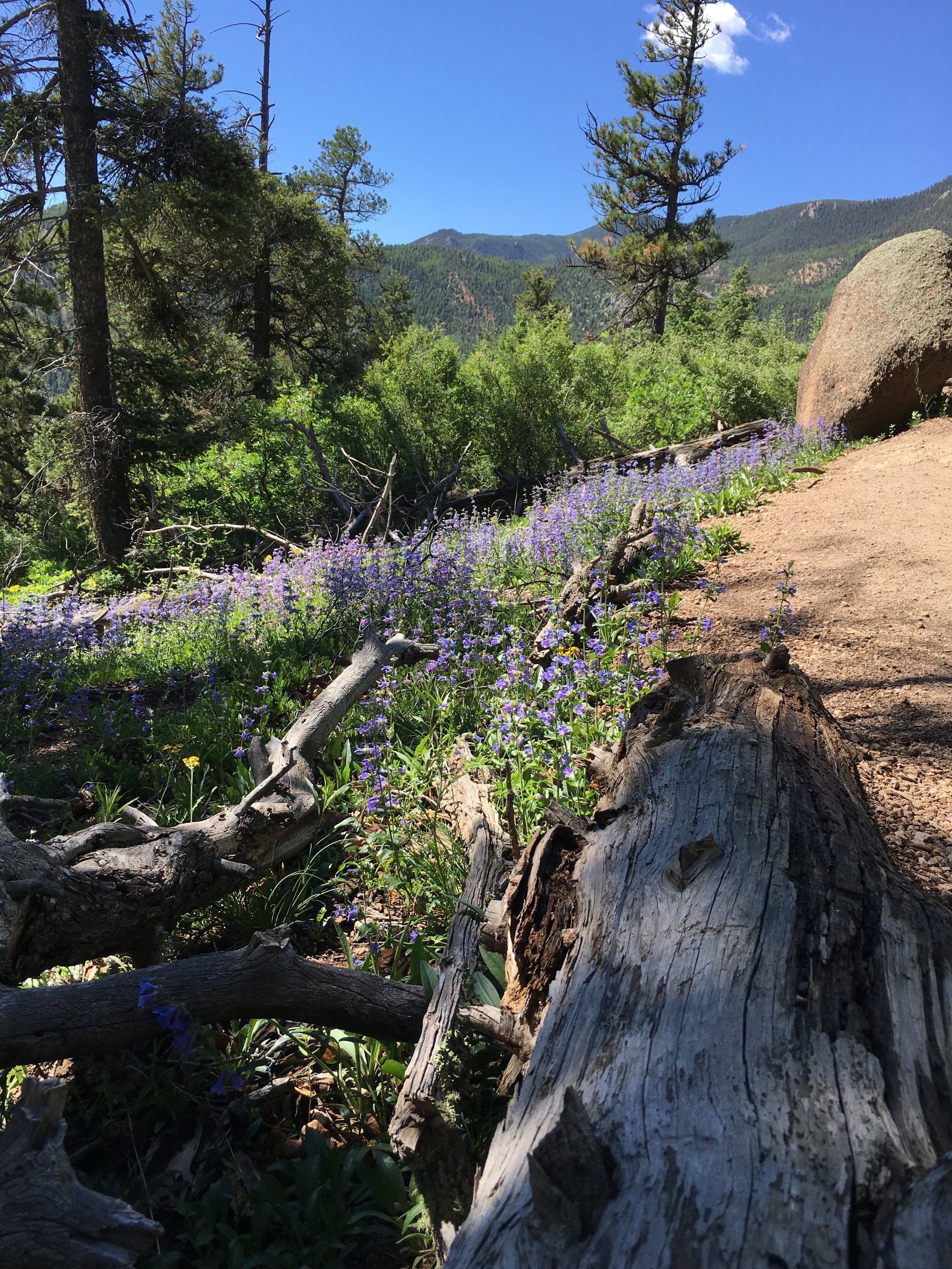
Consider taking an extra hour to head up Barr Trail a bit. Pine trees and aspens flank the trail.
In summer months, wildflowers are abundant. In the fall, you walk through groves orange and red aspens. About a mile from the connector trail, find a beautiful little creek to rest before turning around.
use the bathrooms before you start
Trust us on this one. Emergency bathroom break = no privacy at all!
Slow hikers stay to the right
Be aware of your surrounding
Earbuds are fine. People hike at different speeds. This is one trail you don’t want to be surprised on.
Incline Stair Techniques: success to the top
Rest Step
Rest Step
As you step forward on a climb, lock your rear knee and keep all of your weight on that rear leg.
As you're swinging your other leg forward, relax the muscles in that leg.
Double Step
Double step
Take a step up and meet it with your other foot.
You’ll have both feet on one step before you head to the next one. Once your forward foot comes to rest on the ground, keep it relaxed so that there's no weight on it.
Hands on Thighs. and Knees Step
Walk with Hands on Thighs and Knees
This technique is both effective and energy-efficient. By moving this way you use your arms to push down on your knees and thighs.
You get extra power to push down towards the ground and more power to propel forwards. Lean your upper body forward – getting into this position makes it easier to take in deep breaths.

How to Get Down from the Manitou Incline
Well marked signs tell you where to go for Barr Trail
OPtion 1: The Connector Trail
Once you get to the top of the Manitou Incline, look left. You’ll see the well marked trail taking you to Barr Trail. This trail has been updated recently, making it impossible to miss!
PLEASE STAY ON THE TRAIL! You’ll arrive at a set of steps. Take a hard left to connect to Barr Trail.
Option 2: The Scenic Route
At summit, head straight ahead looking for concrete building ruins. Veer slightly right and take the upper trail between a set of trees. If you are heading downhill, you are on the WRONG path.
Trek uphill for around a quarter mile spotting large boulders along the right of the trail.
Round the corner and you’ll see several rocks on your left. Look straight ahead for a magnificent view of Pikes Peak’s summit.
You can spot the newly renovated summit house on top.
Wander down the path and you’ll arrive at Barr Trail. Turn left to go down.
Want more mileage?
Once you get to Barr Trail, head right. At this point in the trail, you’re 5 miles from Barr Camp, 8 miles from A Frame and 11 miles from Pikes Peak summit.
Red Mountain trailhead
Hike to Acclimatize | Manitou Springs Red Mountain Trail
4.5 miles | 1,161’ elevation gain | Out & Back
If you’re in the area and looking for a great training hike before tackling the Manitou Incline, or just want a different view of it, try the Red Mountain Trail. The trailhead is only minutes away from the Manitou Incline trailhead. You can park in town and use the same shuttle system to access this hike.
Expect some steps, though nothing like the Incline. The trail has a few spurs that allow you to add mileage (as we did). In the winter months, wear spikes as some sections are steep and can get slippery.
Along the way, you’ll enjoy a beautiful stream flowing beside parts of the trail. The top section is rocky, but the views are worth it. This is a perfect hike to help acclimate if you’re visiting from out of town!

What type of Manitou Incline hiker are you?
The Tourist
Your goal is simple: Plug in the headphones, set the beats and get to the top. You take the obligatory Instagram picture, post to social media and run down Barr trail.
The Endurance Hiker
The Manitou Incline is Nature’s Stair climber. Regularly adding this quad burner, butt busting strength routine to your weekly exercise is the goal. You are on the Incline for through hike training, marathon racing hill workouts, and mountain climbing expeditions.
The Lookee Loo Hiker
The views are spectacular as you head up the 2,744 steps. The Lookee Loo likes to take the climb slowly, turning around often to take in the 180-degree views of Colorado Springs and Garden of the Gods
The Socialite Hiker
You love hiking with other people. You love stopping on the way, chatting up the huffing puffing hiker next to you. You number one goal is being part of Colorado’s nature and hiking community.
The Record Holder
You want to beat the record. It’s an ambitious goal. The records are changing daily. Join Friends of the Incline for most recent Incline records. Not only are hikers summiting this crazy Colorado Springs incline climb multiple times at day, they are breaking records pregnant, pushing peanuts and other crazy antics.
No matter what type of Manitou Incline hiker you are, hiking stairs in Colorado Springs will teach out a few lessons about yourself. Keep an open mind and be willing to learn like I did.
More fantastic views around Pikes Peak
What better way to experience this city's stunning panoramic vistas than through the exhilarating Seven Falls ziplines? Whether you're an adrenaline junkie seeking adventure or a nature lover looking for unique ways to see the views, here are the best Colorado Springs ziplines.
Soar above treetops, glide across canyons with your crew, and leave with an unforgettable experience under Pikes Peak. These are some of the longest, highest ziplines in Colorado
When you book this or most other Broadmoor outdoor adventures online and you enter our exclusive reader promo code "COHIKES", you save 10% OFF that experience!

Enjoy several different Seven Falls Ziplines in Colorado Springs
My Manitou Incline lessons with a few views on the side.

Challenge Hill Castle Rock, Colorado
Two Nearby Mini Inclines: Manitou’s Little Sisters
If the Mac Daddy of all Inclines stresses you out, check out these two mini inclines within 40 miles of Colorado Springs and Denver.
Between 180 and 200 steps each, these family friendly trail hikes offer great views and a solid workout while allowing everyone at every fitness level to be together.
Tanya tackling Challenge Hill in Castle Rock
Challenge Hill in Castle Rock
This incline is perfect for an extreme outdoor workout. Throw in a few burpees at the top, do a few jumping jacks and head back down. Repeat for a buns busting workout.
Castle Rock Mini Incline Details
Challenge Hill in Castle Rock is part of the Philip S Miller Park.
The Incline at Castle Rock begins with a 200 step climb up Challenge Hill to the top.
Stop and catch your breath, taking in the views of Rocky Mountain National Park in one direction, the hilly valley beyond the highway in the other. The impressive rock face known as Devil's Head is clear to the west, Pikes Peak to the south.
Run along the trail down, taking the short ½ mile jaunt for the trail’s total of .6 mile.
You have a great outdoor workout, dead set between North Colorado Springs and South Denver (about a 30 minute drive either way.)
Head back up again, adding training miles to your legs. Feel free to explore some of the other 7 miles of well-marked trails. Or better yet, take the kids to the Ninja style playground across from the Incline while you rest.

Parking and MANITOU Incline Trailhead Information
Take interstate 25 south from Denver to the town of Castle Rock, exiting at Wilcox/Wolfensberger exit, taking a right onto Wolfensberger.
At the roundabout, go around and take the left-hand exit (3rd option on the roundabout) onto West Plum Creek Parkway. Go 0.7 mile on West Plum Creek Parkway and the Phillip S. Miller Park entrance will be on the right.
Incline parking is on the left.
Family Fun Day Option
Check out the Adventure Park on site.
field house with turf fields
batting cages and a golf simulator
trampoline play area and pool
10 of the area’s longest and fastest zip lines
three-story ropes course
Nearby Hikes
Castle Rock Park
Free. Kid Friendly. Dogs Allowed. Easy 1.3 mile loop hike. Hiking Cred: Hiked “that crazy looking rock”
Castlewood Canyon
Waterfalls. Family friendly trails. 14 hiking trail options. About 14 miles east of Castle Rock.
LOCAL TIP! Do the Inner Canyon Loop. The waterfall is worth the 5.8 mile loop.
State Park = not free. $10/vehicle or $4/person for any non-vehicle entry.

Ruter-Hess Mini Incline, Castle Pines, Colorado
Rueter-Hess Mini Incline
Check out southern Colorado’s newest incline, opened December 2020.
This trail boasts 132 steps of 232 feet of elevation. Lace up your shoes, grab your bottle of water and start climbing stairs. Few people know about this incline, making it the perfect solo stair climbing experience.
Located just north of Castle Rock and across the street from the Rueter-Hess Reservoir, it’s an easy drive from Denver and Colorado Springs.
This hill is the incline view from the parking lot.
Rueter Hess Mini Incline Details
The complete loop, from the parking lot, up the stairs and down the trail hill is just over 1 mile.
At the incline summit, you’re rewarded with views of the Reservoir to your right.
As of now, the reservoir is not open to the public but plans are in the works to add docks for SUP and non-motorized boats.

Parking and Manitou Incline Trailhead Information
It’s a bit tricky to find. Coming off I 25, head toward the Rueter-Hess Water Purification Facility. Turn left onto Heirloom Pkwy and take the first left into an access road.
LOCAL TIP! If you’ve reached a neighborhood, turn around. You’ve gone too far.
Two very clean porta potties, a well labeled trail map and and ample parking set you up for success. The Reuter-Hess Incline is about a 5 minute drive off I 25.
Nearby Trails
Bluffs Regional Park 10099 Crooked Stick Trl Lone Tree, CO 80124
3 miles of trail
Stunning views of the entire front range, from Pikes Peak to Longs Peak and beyond.
Plenty of parking and restrooms as well as bike repair station
Waterton Canyon 12491 Waterton Canyon Littleton, CO 80127
Nice, flat wide trails
Biker friendly.
13 mile loop trail.
Animal spotting. Check out the big horn sheep and their babies.
It gets hot so take plenty of water!
No matter which incline you pick, you are sure to get a heart pounding, lung bursting experience. Do you have a favorite? Let us know!
You’ve earned the burn and all the food. Hop on over and grab a drink or bite to eat!

Manitou Springs Hops
Breweries and Restaurants near the Manitou Springs Incline
Manitou Brewing Company
Grab a beer flight and truffle fries. The chocolate stout is a must. Order the Bronco Burger for the complete package. 725 Manitou Ave, Manitou Springs, CO 80829
Swirl
With a large selection of beers and cocktails, Swirl has a laid back environment with a beautiful little outdoor patio. Check out their goat cheese salad and flatbreads. 717 Manitou Ave, Manitou Springs, CO 80829
The Key Lounge
Pub food at it’s finest. Order the Killer Cheesy Bread. They have one of the best Reuben sandwiches in town, made with real corned beef. Beers and drinks. 730 Manitou Ave, Manitou Springs, CO 80829

Check out the Best Breweries in Colorado Springs Guide.
We’ve mapped out the coolest spots by neighborhood, from places with live tunes to the best breweries in Colorado Springs that serve up delicious food, cozy outdoor spots, and a warm welcome for your furry friends.
Castle Rock Hops
Wild Blue Yonder Brewing Co
Bavarian nachos are a must. Beers are great and unique. Try the Colorado Koolaid Hazy IPA or Peanut Butter Patty Oatmeal Cream Stout. 519 Wilcox St, Castle Rock, CO 80104
Burly Brewing Company
Food trucks on site to go with your beer. Try the sours or the Amber Beer. 680 Atchison Way #800, Castle Rock, CO 80109
Castle Pines Hops
Downhill Brewery
Get the flights to get a great sampling of the beers they offer. Thin crust pizza is outstanding. Very kid friendly and outdoor seating. 18921 Plaza Dr, Parker, CO 80134
Welcome Home Brewery
Dog friendly with a warm and cozy atmosphere. The Stout is worth a taste. 19523 Hess Rd #103, Parker, CO 80134