
Hiking Pikes Peak, The Highest Mountain In Colorado Springs
This page contains affiliate links. If you make a purchase via a link on this page, we make a small commission at absolutely no extra charge to you. Thank you for your support of this small women-led business.
Pikes Peak is America’s Mountain
Complete 2026 guide to hiking Pikes Peak with three main trails, the newly reopened Catamount Reservoirs loop, and insider tips on reservations, parking, and the famous summit donuts.
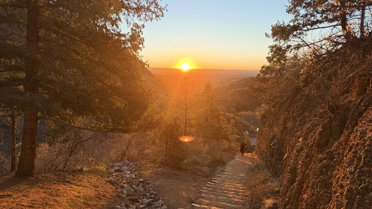
Hiking along one of PIkes Peak trails
The Pikes Peak Hike
Are you ready to climb the highest mountain in Colorado Springs? Wondering how long does it take to hike Pikes Peak? Curious how to climb this majestic mountain?
Then let's go! We'll show you how to prepare for your journey up Pikes Peak.
The 14,115 ft. summit of Pikes Peak is located in Colorado Springs, CO. It was first climbed by Edwin James on July 14th, 1820. Three men were sent on this military expedition in hopes of expanding the US borders. James’ trail notes are available to read in the Library of Congress.
Did you know you can also drive to the top of Pikes Peak on a paved highway? Maybe riding on the world’s highest cog railway is more your speed. You can even bike down this famous fourteener.
But first, we’re here to tell you how to hike Pikes Peak. After that, we'll unveil thrilling alternatives, including a unique route beloved by locals, guaranteed to be anything but average!
What's New on Pikes Peak for Summer 2026
A lot has changed on America's Mountain in the past year. Here's the short list:
North Slope Recreation Area reopened May 1, 2026. After a two year closure for dam rehabilitation, North and South Catamount Reservoirs are back. Jump to our Catamount trail guide.
Crystal Creek Reservoir is still closed for the season for warranty maintenance work. The parking lot, visitor center, and local trails remain open.
Summit reservations are required Memorial Day weekend through September 30. NSRA only visits do not require a summit reservation.
Pikes Peak Highway entry: $18 per adult, $8 per child (ages 6 to 15), or $65 per carload for up to 5 passengers.
NSRA entry: $5 per guest, $1 parking permit, kids under 16 free.
Updated May 2026.
Table of Contents
How To Hike Pikes Peak - preparation
How to Get to Pikes Peak
Pikes Peak Main Trails
Hiking Pikes Peak on other routes
Barr Camp
other Ways to get up and down Pikes Peak
Bike Down Pikes Peak
SUP on Pikes Peak
Best time to go
Fourteeners Near me
Where to stay in Colorado Springs
What to Do in Colorado Springs
Start with a good pair of shoes
Before we get into all the hiking routes answering the bit question, how long does it take to hike Pikes Peak, it’s important you have a good sense for how to prepare for this hike!
You need to start with a good pair of hiking boots. They should fit well and provide support for your feet. If you're going to hike more than an hour, make sure you wear comfortable socks. We are partial to Smartwool socks (nope, the wool is not scratchy at all!) for comfortable, cozy feet no matter the season we are on a Pikes Peak hike.
If you’re unsure where to even start with the whole hiking shoe situation, head to our shoe post. We tell you what to look for, how to fit the right shoe, what we love and how often to switch those babies out!
Need coffee before tackling Barr Trail? Here are the best coffee shops in Colorado Springs to fuel up.
Trekking Poles
Melody’s daughter changed her mind about trekking poles. Take a listen.
Trekking poles aren’t just for old people! Let’s debunk that theory right now.
When Melody and her daughter backpacked Four Pass Loop this past summer, her daughter was suspicious of bringing trekking poles along. That is until day one, 5 miles into hiking Four Pass Loop. Hear about her new respect for trekking poles.
Trekking poles do a whole lot more than look cool. They collapse for easy daypack storage, quickly making them accessible for balance while crossing water. Or use as a weapon to scare away snakes.
Keep the puffy hand syndrome at bay and bulk up those biceps. Using trekking poles gives the hiker a full body workout. Overall, the trekking pole is a handy dandy tool for all ages.

Altitude
How to hike Pikes Peak is a pretty simple recipe:
Put on your gear
Load up your daypack
Start walking
BUT….
Colorado’s altitude can be challenging in many ways, and the elevation and strong sunshine will take a toll if you’re not careful.
If your goal is summiting Pikes Peak from a lower elevation, give yourself a day or two before you start the hike. Consider a shorter acclimating hike to see how you feel. There are several short and easy hikes near Manitou Springs.
Give yourself time to rest here and there on your Pikes Peak hike and drink lots of water. Pay attention to what your body is telling you and tell your hiking buddies if you’re not feeling well. Bring plenty of water
You will also need to bring some additional supplies with you. These include a first aid kit, flashlight, map, compass, snacks, and more.
Food
This is the best part of the hike right? Pack things that sound good - many people find longer hikes create some weird taste issues.
Altitude Snack Guidelines:
Pack something salty and something sweet
Bring a few high protein treats like jerky or meat sticks
Carry some electrolyte tablets (we’re big fans of NUUN)
Trail mix with dried apricots and raisins helps with muscle cramping
FUN FREEBIE! Peel an orange and add it to your water bottle. You’ll have a yummy snack when you’ve drank all your water (plus it makes the water taste extra great).
Depending on your speed and plans to overnight at Barr Camp determines how much food and water to bring. We tend to overpack snacks. However we practice a highly regarded
CoHH MANTRA: You can never have enough food.

Osprey’s Sirrus 24L is perfect for a day hiking Pikes Peak
Pack light
Make sure you pack only what you absolutely need. Leave behind anything that isn't essential. This includes extra clothing, food, water, sunscreen, and other items.
Keep in mind essential hiking gear doesn’t take too much room and could save your life.
Hiking any fourteener requires a decent backpack. This is one time you want to keep Dora the Explorer at home. Your body will be sore after this hike. Don’t make it worse by using your child’s school daypack.
NOTE! We carry the Sirrus 24L Daypack on all our hikes. It is efficient in storage with a nice wide hip belt, making it easy to fit and access essential hiking gear (read SNACKS) on any Colorado hiking trail.
Osprey has a handy dandy packfinder tool. Answer a few questions and BAM, you’ll know exactly what type of daypack is made for your body.
Osprey has incredible customer service. They repair and replace with their lifetime warranty. This is one product you get a bang for your buck!
Be prepared for weather changes
Pikes Peak weather changes can affect your hike. If you're hiking Pikes Peak in July and August, you should expect hot temperatures and high humidity. During winter months, you might encounter snow and cold temperatures. It's important to pack appropriate clothing for each season.
Check the weather BEFORE you hike. Find out when thunderstorms are predicted to roll in. Hiking on exposed trail is scary and life threatening.
Hiking Pikes Peak in August is prime thunderstorm season. If you do get caught in lightning, get to treeline as fast as possible!
Know where you're going
You need to know what you're doing before you start climbing. Make sure you understand the trail, elevation gain, weather conditions, and other details. Also, make sure you have enough water and food with you.
Be realistic
Anytime you prepare for hiking hard routes in the mountains, it is crucial to do so with a realistic mindset.
If hiking Pikes Peak seems a bit out of reach this visit, enjoy a trip to the summit on the Cog Railroad or Pikes Peak Highway.
Pikes Peak in August
Everyone on top gets to enjoy the same sweeping Rocky Mountain panorama, no matter how they got there!
The weather has a major influence in determining just how long does it take to hike Pikes Peak. I’ve hiked this mountain several times, averaging 5-10 hours from base to summit.
Each trip was different depending on who I was hiking with, their skill levels, and the weather.
When I took my son up Pikes Peak as a 12 year old in August, we got hit with a massive snowstorm 3 miles from summit. It slowed us way down. We had a ranger drive us down as the road was closed due to white out conditions.
Related Links:
Beginners hiking tips for successful Colorado hikes
Find out what to wear hiking in Colorado
Get the best fitting hiking daypacks that work hard like you do
Make sure to have all the essential hiking gear for your daypack
Pikes Peak Summit can be very windy and cold in the summer.
Know what to wear
Hiking a 14er requires layers. To know exactly what we wear on each 14er hike, head to our full 14er post.
Pants matter more than people realize on a fourteener. The right pair handles morning chill, afternoon sun, surprise summer snow, and the occasional scramble over rocks. We tried, tested, and ranked our favorite hiking pants for women so you can show up to Pikes Peak in the right gear.
We learned a thing or two over the past 25 years of hiking 14ers that just might come in handy for you.
That said, here’s what is usually our go to Colorado hiking gear.
OUR GO-TO GEAR FOR COLORADO HIKING TRAILS IN 2026:
We love the Osprey Sirrus Hiking Daypack for women, or the Stratos version for men, for carrying water, layers, and snacks on Colorado day hikes
Lightweight, versatile Hiking Poles built for a full day’s send on the trail — hike longer and stronger
The best women’s hiking pants tested on Pikes Peak and other Colorado fourteeners.
2L or 3L Water Reservoir — This affordable reservoir is easy to fill
Patagonia Torrentshell - a true waterproof rain jacket and fantastic layering piece
Nano Puff Jacket - our favorite for 3 seasons in Colorado
Smartwool Glove Liners - the best all season gloves for those high altitude hikes
TOPO Traverse running shoes - comfy and hard working for any type of hike
Gearing up for your first fourteener? Save money with our guide to affordable used hiking gear in Colorado Springs.
How to Get to Pikes Peak
Directions vary depending on what route you take hiking Pikes Peak.
Barr Trail:
Get on I-25 S. Take US 24W to Serpentine Dr in Manitou Springs. Continue on Serpentine Dr. Take Manitou Ave and Ruxton Ave to Hydro Street. Parking lot is on right side past Cog Railroad.
Crags Trail:
Get on I-25 S. Follow 125 S to US 24W. Continue to CO-67 S in Divide. Continue on CO-67S to Teller Co Rd 62. Turn left onto CO-67 S. Turn left on Teller Co Rd 62. Trailhead will be on the left.
Devil’s Playground:
Note! Pikes Peak Road is closed in winter. Reservations required!
I-25 S to US-24 W to Fountain Ave in Cascade- Chipita Park. Follow Pikes Peak Hwy and Pikes Peak Toll road to your destination in Teller County. Turn left onto Fountain Ave. Slight left onto Pikes Peak Hwy. Pikes Peak Hwy becomes Pikes Peak Toll Road (CLOSED in winter). Destination will be on the left.
COHH TIP! Make sure you tell the attendant if you’re not driving all the way to the top of Pikes Peak; your entrance fee will be much cheaper. Driving Pikes Peak Hwy requires a reservation.
INSIDER TIP | PARKING AT PIKES PEAK SUMMIT!
Driving to the top of Pikes Peak now requires A LOT of planning. Here are a few tips to make it easier for you!
Arrive by 9 am (earlier is better) to entire through the highway gate.
Purchase the appropriate 2 hour timed entry (8-10 am, 10-12, and so on) If you think you’ll be there longer, buy additional time!
Print out and disp;ay your pre-purchased timed entry pass on your dashboard.
The Pikes Peak Highway team actively checks timed-entry permits.
One of many Pikes Peak trails to the summit
Different Routes to Reach Pikes Peak
There are three main trails for hiking Pikes Peak: Barr Trail, Devil’s Playground and the Crags. Each of these Pikes Peak trails offer different views and distances. The most famous, Barr Trail, is raced every year for the Pikes Peak Marathon and Ascent.
How to hike Pikes Peak depends on what type of day you want to experience and how much time you have.
Take Barr Trail for a long meandering trek up America’s mountain. If time is an issue but you want to knock out this 14er, hike Devil’s Playground trail. Crags trail is perfect for a more solitary experience.

Hiking Pikes Peak via Barr Trail - the path to A Frame
Barr Trail
Mileage 25+ miles RT Elevation gain 7,434 ft. Route type Out & back
Well marked sign at Barr Trail parking lot
Starting at Barr Trailhead, make a quick stop at one of two flushable toilets before beginning. Don’t forget to pay for parking and put your parking pass ($10/day) on your car’s dashboard.
Note! There is regular security monitoring of this parking lot so your car is relatively safe. Make sure to keep valuables out of sight and lock up before hitting the trail. (Psst…put your car key in a safe spot in your daypack.)
Boys taking a break before the final 2 mile push to Pikes Peak Summit
This Pikes Peak hike has plenty of switchbacks. Trekking poles come in handy navigating the rocky terrain. Expect elevation gains of almost 4,000’ in the first 6 miles of this trail.
Aside from the first 2 miles and last 3 miles of the trail, you’ll be in shade for the majority of this hike. Beautiful tall pine trees, scrub oak and rock formations line the trail as you wind up the mountain.

Backpackers approaching Barr Camp on a two day Pikes Peak hike
There are a few creeks for water fill ups depending on what season you’re hiking Pikes Peak. Rather than relying on these water sources, carry at least 4 liters of water.
A variety of views span the almost 13 mile trail. For much of this Pikes Peak hike, hiking will be among trees and scrub oak with smatterings of bright sun. Don’t forget sunscreen. You’ll be fooled into thinking you’re well shaded. Colorado’s high altitude sun gives a mean sunburn even when cloudy!
The famous 16 Golden Stairs
Past the Fremont Experimental Forest sign, stay to the right on the single track trail. Do not take the wide road if summitting is the goal. That road does NOT continue to the summit.
Around mile 8 is Barr Camp. With camping and bunking options, this a great spot to take off the backpack and relax for the day, choosing to hike to the summit the next day. (See section below on Barr camp reservations, food and accommodations.)
However, if this is a day hike for you, filter some water, use Barr Camp’s compost toilets and tackle the remaining 5 miles to summit.
Note! Keep in mind these last 5 miles will be much slower than the first 8. Hiking Pikes Peak starts around 6,700’, topping out at 14,115’ at the summit.
Melody’s son hanging out in snow (in early August) near Pikes peak summit
Heading out from Barr Camp, stay on the well marked trail to A Frame, an unmanned, first-come, first-served, six-man shelter at 12,098’.
Reapply sunscreen and start trekking. These last three miles are the hardest - the terrain is rocky, the trail is steep and the air is thin.
There are some pretty famous sights in the last three miles of the hike. Look for the Bottomless Pit and Pikes Peak Summit sign - that means only 2 miles to go!

Barr Trail gets very rocky the last three miles to summit.
Shortly after that sign, begin hiking over the Cirque, probably one harder parts of hiking Pikes Peak. Stay strong and continue to the 16 Golden Stairs. Whoever named it stairs was not nice! It’s 16 switchbacks not actual stairs.
Keep your chin up and breath. The end is in sight. Get to the top, head into the new Summit House and grab a high altitude donut. Use the super clean bathrooms, take a little tour and meet up with your ride down.
OR turn around and start hiking down. If you’ve not arranged for a ride down, make sure to begin the trek down well before storms move in around 2 pm.
CoHH Tip! Use the Garmin Inreach Mini to keep in correspondence with your ride. Rangers check times up top. During peak season (July/August), cars are only allowed 2 hours at summit. Cell phone service is spotty at best for most of the Pikes Peak hike. If you get stuck up top, you will be charged for the ride down. See note below for Trail Down Options.
For a detailed summary of Barr Trail, check out famous Pikes Peak Ascent and Marathon winner, Matt Carpenter’s detailed account of each part of the trail.
Summit House at Pikes Peak Summit
LITTLE SECRET! Did you know they built an emergency hiker’s room (with heat!) in the bottom of the summit house? This is always unlocked for hikers who might meet calamity on the mountain.
Taking a break on one of Pikes Peak trails: Barr Trail
Trail Pros
Well-marked trail
Shade for most of the mileage, top 3 miles are exposed
Barr Camp
Trail Downsides
Long hike with tons of elevation gains *Takes 6-10 hours to summit. Many do this hike in two days.
First third of Barr Trail has steady stream of Manitou Incline traffic. Watch out for runners!
One of a few summit drive options - expect cars and crowds up top.
Lightning storms are almost daily in the summer. Get off the mountain’s summit before noon.
Paid Parking *Budget $10/day for TH parking.
Taking a moment to admire the view on Crags Trail
Crags Trail
Mileage: 14.5 mi. Elevation gain: 4,402 ft. Route type: Out & back
Start this Pikes Peak trail near Divide, Colorado. It’s well shaded for most of the hike, among pine trees.
Hiking Crags Trail on Pikes Peak
If an early start to hike this fourteener is your jam, consider camping at the Crags Campground. First come, first served with 17 camping spots, the Crags Trail is literally right next to the campground. This makes it ideal for completing your Pikes Peak hike before noon.
Dispersed camping is allowed. Make sure to pitch tents at least 300’ from any water source.
CoHH Tip! Stay two nights in this campground and explore many of the nearby trails. Potable Water and Pit Toilets on site but no trash service.
Crags Trail starts on Forest Service Road 383. Expect the first 1/2 mile of the trail to be tricky with a steady uphill incline. Same goes for the last 1/2 mile right before the Crags.
Hike a short ways to Fourmile Creek, turning right to hike trail #664A. A bridge crossing here makes this easily recongizable. Continue through the forest, making several switchbacks until treeline.
Enjoy a meandering hike through meadows filled with wildflowers in July and August. Fall brings brilliant colors throughout the lower half of this hike.
Look to the west for unobstructed views. The 3/4 mile before Devil’s Playground is a steep straight climb up the saddle, reaching 12,750 feet.
Cross Pikes Peak Highway, staying on the left side of the road for around 2 miles. Begin final ascent up to the large boulder field and on to the summit.
Cairns mark the way through the maze of rocks
Note! This first half of this hike is less traveled making wildlife sightings common.
Practice the thumb rule. If your thumb cannot cover the animal, you are too close. Back off. Bring bear spray, make noise and keep an attentive ear out.
Hiking towards Devils Playground on Crags trail to Pikes Peak summit
Trail Pros
Shorter and with less elevation gain
Better views with the Continental Divide to the west
Much less crowded trail
Trail Downsides
Road to trailhead is rough, AWD and 4WD is preferred to get there
More wildlife so be attentive
Rocky terrain throughout hike on Devils Playground route.
Devil’s Playground Trail
Mileage: 5.5 mi Elevation gain: 1,348 ft. Route type: Out & back
Almost to the summit after passing Devil’s Playground on PIkes Peak
Melody and Tanya’s eldest kids tackled hiking Pikes Peak via Devil’s Playground Trail one early morning. With a friend in tow, they hopped on Pikes Peak Highway and sped up the road.
This is the shortest trail to Pikes Peak’s summit, coming in just under 6 miles. They started around 5 am and called us from the top at 9 am. Granted they are athletes with quick feet, this still is the easiest of the three main Pikes Peak trails to hike.
Melody’s daughter Caroline gave her opinion below on this particular trail. Here you go, in young adult terms, the good, bad and ugly of hiking Pikes Peak via Devil’s Playground Trail.
Note! Instead of hiking from Crags Trail, drive Pikes Peak Highway until you reach Devil’s Playground. All the trail details starting at Devil’s Playground from above pertain to this hike.
Trail Pros
A much faster way to get to the top without having to do Barr Trail
Wish we had started at devil’s playground because that’s more scenic (they drove up a bit further to knock off some time)
Trail Downsides
Most of the hike is along the highway so there are lots of cars.
Exposed to the sun the whole time
In Her Opinion: “I would not choose to do it that way again. It probably would have been better to start at Crags Trail but even then I really didn’t enjoy hiking along the highway.”
If you have time, consider hiking Barr Trail and Crags Trail. They are longer with greater elevation to tackle. However, stunning views make these trails, in our opinion, the better options to hike Pikes Peak.
The Manitou Incline at dawn
Manitou Incline to Barr Trail *The Local’s Secret Path
Mileage: Depends - around 13 miles to summit Elevation gain: 7,611 feet Route type: Out & Back or Up the Incline, down Barr Trail
Locals adore the Manitou Incline, a global magnet for hikers tackling its challenging one-mile ascent on ancient railroad ties. Now, if you're feeling like a true hiking beast, extend the adventure by conquering the additional 10 miles to reach the summit of Pikes Peak – that's no small feat, my friend!
Beginning your Pikes Peak Mountain journey via the Manitou Incline is no walk in the park! Covering roughly 0.88 miles, brace yourself for a 2,011-foot elevation gain. Once you hit the connector Barr Trail, be prepared for another 5,600 vertical feet to reach the Pikes Peak Summit. It's a formidable challenge, reserved for the most determined hikers out there!
Melody, gearing up for the Pikes Peak Ascent, tackled this route twice. It pushed her to the limit, but oh, the views of Pikes Peak are absolutely worth it!
If you're considering the Manitou Incline, we've got the lowdown in a dedicated post. Be ready for some strategic planning, reservations, and a reliable drop-off buddy, as overnight parking is a no-go at the Manitou Incline lots.

Take a rest break at the cement foundation before connecting to Barr Trail
DIRECTIONS TO CONNECT TO BARR TRAIL:
Once you’ve summited the Manitou Incline, plan on climbing a little higher over the old building foundation. You'll see a nice smooth flat path, don't take it as it dead ends. About 40 yards to the right of the path that dead ends, look for a steep climb marked by a post with no sign. This path looks washed out through the middle. That’s your trail! This path is hidden behind a pine tree when you are standing on the old foundation.
TRAIL PROS:
Bragging rights for years. Hiking Pikes Peak Mountain is made much harder with this beginning first mile
A fun and local way to explore Pikes Peak like a local
Cut off 2 miles one way - You’ll start Barr Trail around mile 3 at the turn off.
TRAIL Downsides:
Starting the Pikes Peak hike with a large pack up a steep route = CHALLENGING
No extra time is gained by this route.
Other Hiking Trails on Pikes Peak Mountain
Elk Park Trail towards Pikes Peak summit
Elk Park Trail
Mileage: 23.5 miles RT Elevation gain: 5,931 ft Route type: Out & back
Trailhead sign at parking lot of Elk Park
Similar to Devil’s Playground trail, Elk Park trail starts halfway up Pikes Peak off the Pikes Peak Highway. NOTE! Reservations are required to access this road.
Elk Park trail, one of the many Pikes Peak trails to summit the mountain is a multi use trail, heavy on the biker usage. Traverse across several hills and head down the first 2ish miles. Keep in mind that the return will be uphill for the those last 2 miles.
Getting to Elk Park Trailhead is hair raising. As you round a curve to the trailhead, you’ll see a small gate on the side of the mountain. It will feel as if the car is headed over a cliff, never to be seen again.
Stay true to the map directions and we assure you, there is ample parking and space for your car and several others.
friendly bikers headed up PIkes Peak via Elk Park trail
Park at the top of the road on the hill. There is a helipad for first responders on this section.
The trail is well marked. At the trail’s only junction, Oil Creek and Barr Trail, turn right and hike the 5 1/2 mile hike to Barr Camp. You’ll continue to A Frame and summit from Barr Camp.
*For a detailed description of the last 3 miles to summit, see the above notes from Barr Trail.
Keep in mind sharing trails with mountain bikers means you have priority. However, this particular trail, especially on weekends, is filled with bikers. They have a much harder time stopping and pulling aside vs. the hiker taking a few steps to the right.
For even more remote trails that meet up with Barr Trail, check out the Pocket Pals map of Pikes Peak. These waterproof, tear resistant maps show many trails on the mountain, including way points and other helpful hiking tips.
Love a long, challenging hike? Consider summiting Mount Rosa, which offers sweeping views from 11,533 feet, including seeing Pikes Peak.

Pocketpal Maps for Pikes Peak Area
PocketPals Pikes Peak series of maps (#5,6,7,8,9) have extensive trails marked Pikes Peak. For a comprehensive trails in one map deal, pick up the Pikes Peak 14er Climbing and Hiking Map (trails used to summit Pikes Peak)
PROMO CODE: “10%OFF” gets you 10% off all maps. Prices vary but average $7–$10/map including download.
Ready to head up the final 5 miles to Pikes Peak Summit
Overnight Camping at Barr Camp
Bunk beds at the Barr Camp cabin were spacious and roomy.
When Melody’s kids were young, the hike up Pikes Peak was a milestone event. Taking two days, we’d grab breakfast and trek up to Barr Camp for the night.
Up early the next day, the goal was summit Pikes Peak by 10 am, high fiving and celebrating with the high altitude donuts of course!
A camp host manages Barr Camp, a campus 8 miles up Barr Trail. The year Melody took her daughter, our host had just completed his eighth year of running Leadville 100. We were delighted by tales of the race and of course, asked to see the famous belt buckles.
Hikers have two main options for overnighting on the peak; camping or staying at Barr Camp bunkhouse.

Backpacking Pikes Peak Mountain
Recently, Melody’s eldest daughter and her friends backpacked to Barr Camp, spent the night, and summited Pikes Peak the next morning. Here are some tips they shared:

It gets cold at Barr Camp, even in July. Be sure to pack layers and a backpacking quilt to stay warm.
While camping reservations are recommended, you can camp anywhere on the mountain as long as you LEAVE NO TRACE.
Start your summit day early. They set out at 4 a.m. to catch the sunrise and avoid afternoon storms.
Plan your descent in advance if you’re not hiking back down Barr Trail. Options include:
Having a friend drive up (note: a reservation at the summit is required, with a maximum of 2 hours parking).
Hiking up and taking the Cog Railway down (pre-purchase a ticket, but be prepared to wait if the train is full).
Expect a lot of wind and varied weather at the top. Pack hat and gloves along with a jacket.
Make sure to bring a comfortable and warm sleeping bag if camping. Even in the summer, sleeping on a mountain can get downright chilly. Consider these 5 features to look for in a sleeping bag to stay light in your pack but cozy while you sleep. Whether you're hiking Pikes Peak or planning a similar adventure, these tips can help you prepare!
keep these things in mind:
Barr Camp is approximately 6 1/2 miles up Barr Trail starting from Manitou Springs
Indoor “glamping” options: bunkhouse, lean to, upper cabin (price per night ranges from $15-$35)
Camping anywhere in the National Forest is free. Please practice Leave No Trace principles.
If you stay at Barr Camp, partake in their scrumptious pancake breakfast (included in reservation) and yummy spaghetti dinner (additional price)
Clean composting toilets
NOTE! The Barr Camp website has extensive details regarding reservations, amenities, routes to hike and options for food.
For a full list of what to bring backpacking Colorado trails, grab this FREEBIE -
RELATED LINK: In one quick post, learn all you need to know about backpacking Colorado Trails!
Alternative Ways to Get Up and Down Pikes Peak
Pikes Peak Cog Railway train waiting at the 14,115 foot summit
Hike Up, Drive down
Most hikers take this approach if roundrip is not part of the hiking plan. If you decide to hike round trip, make sure to plan a very early start to avoid lightning. Early morning means before 4 am if possible. Get a good headlamp, wear layers, pack your daypack and start hiking.
A stunning sunrise will be reward enough for the early hour. Well, an enough time to throw back a great ale in Manitou Springs post hike.
If that seems too daunting, consider the most common option - arrange a ride down.
Hikers taking a rest break at the top section of Pikes Peak
Choosing Devil’s Playground Trail is the only option that allows a quick roundtrip not dependent on a ride. Otherwise, plan on bribing a friend or family member to come and get you at the top.
Keep in mind that during summer months cars are allowed 2 hours maximum at summit. Hike with a satellite device, the Garmin inReach Mini works great, so you can coordinate your ride. How long it takes to drive to the top of Pikes Peak depends on the comfort level of the driver. Average driver takes around 90 minutes.
Hitch a ride at your own risk.
Pikes Peak Summit mountain views
Cog Up Pikes Peak and Back Down
The Broadmoor Manitou and Pikes Peak Cog Railway underwent a multi million dollar renovation, reopening May 2021. Touted as the world’s highest cog railroad, riding the Cog is a wonderful way to get to Pikes Peak summit without too much huffing and puffing.
We had front row seats to this comical turn of events on the Cog railroad.
Tickets are pricey (starting just under $75) and go quickly in summer months. Book your trip at least 4 months out to ensure seats together. Make reservations here for the Cog.
CoHH Tip! When reserving Cog seats, pick the three side seats (left side of train as you face forward) vs. the two seat side. The best picture taking views are on the left side as you head up the mountain.
Viewing stage from Pikes Peak summit
A conductor shares history of the area along the ride. Plan on 45 minutes at the Summit before heading down the Cog.
Layers and water are great for altitude up top. Expect lightheadedness and shortness of breath.

Bike Pikes Peak with Broadmoor Outfitters
Cog Up Bike Down Pikes Peak ADventure
Broadmoor Outfitters provides an exciting twist on tackling this mountain. Plan this unique day activity, taking the Cog Railway up the mountain and biking down Pikes Peak Highway.
We had a chance to go on this Cog Up Bike Down adventure with our teens. Boy was it a fun, albeit hair-raising experience.
Preparing to bike down Pikes Peak
This All Day Adventure includes tickets up the Cog Railway. We had front row seats up the mountain. Two mountain goats caused quite the ruckas when they refused to get off the train tracks. No matter how hard the conductor blew her horn, they were not budging.
Nature always wins right?
Take this thrilling ride - bike Pikes Peak!
Eventually we got to the top, toured the new Summit House and then geared up for our bike down Pikes Peak.
Broadmoor Outfitters provides all your safety gear, from form fitting helmets to elbow and knee pads. Each biker is equipped with a bike, backpack loaded with snacks and water along with a bright neon safety vest.
As we biked down Pikes Peak Highway, a guide remained in front, maintaining the route and speed. A van followed behind, ensuring no one passed our group as we wound down the mountain.
What a memorable experience to see this fourteener from a different angle. Tanya’s video of some of the bike ride down Pikes Peak gives you a taste of the adrenaline filled moments.

More fantastic views around Pikes Peak
What better way to experience this city's stunning panoramic vistas than through the exhilarating Seven Falls ziplines? Whether you're an adrenaline junkie seeking adventure or a nature lover looking for unique ways to see the views, here are the best Colorado Springs ziplines.
Soar above treetops, glide across canyons with your crew, and leave with an unforgettable experience under Pikes Peak. These are some of the highest, longest ziplines in Colorado.
When you book this or other Broadmoor outdoor adventures online and you enter our exclusive reader promo code "COHIKES", you save 10% OFF that experience!*
*Save when booking the Cop Up / Bike Down experience, by entering COHIKESCOG for 5% off.
Hike Up, Ski Down
We’ve heard the skiing on Pikes Peak is pretty fun. PocketPals Maps has 6 backcountry ski lines marked in the Pikes Peak map. If you’re curious, check out Mountain Jackpot News description of each of the below routes. They include:
The Bowl (aka Big Blue) - intermediate/difficult
The Chimney - difficult
Cornice Bowl - intermediate
Little Italy - difficult
Old PIkes Peak Ski Area - intermediate
Y Couloir Middle Fork - difficult
Cog Railroad in Manitou Springs, CO
Hike Up, Cog Down
Buy a one way ticket on The Broadmoor Manitou and Pikes Peak Cog Railway. Tickets are available for purchase with the conductor of the train if there is room available.
To reserve your one way ticket ahead of time, call 719-685-5401.
Note! Read the print above - IF ROOM AVAILABLE. In the busy tourist summer months, when most people want to take a Pikes Peak hike, the train is full.
Reserving a seat ahead of time is your best bet for a ride down.
Catamount Reservoir Trail Loop: Newly Reopened on Pikes Peak (May 2026)
Mileage: 9.18 miles | Elevation gain: 1,043’ | Route: loop
Starting Elevation: 9,190’
After a two year closure, the North Slope Recreation Area on Pikes Peak reopened on May 1, 2026. Colorado Springs Utilities finished up a major dam rehabilitation project at South Catamount, and vehicles can now access both the North and South Catamount Reservoirs again.
Translation? A pristine, alpine corner of Pikes Peak is back.
Melody headed up the day after Memorial Day to see what the refreshed trails look like. Short answer: stunning.
Hiking the newly reopened Catamount Reservoir trail loop on PIkes Peak North Slope Recreation Area
What to Expect on the Catamount Reservoir Trail Loop
This loop around both reservoirs comes in just under 10 miles with a gentle 1,000 feet of elevation gain. Sitting at 9,200 to 9,600 feet, the altitude is honest but kind.
This is a Pikes Peak hike for almost everyone. Kids. Visiting in laws. The friend who blanches at the word fourteener. Bring them all.
Start at the trailhead between the two reservoirs. Pick up the trail along the shoreline. Pine forests give way to aspen groves. Water views come and go. Pikes Peak presides over the whole thing.
The trails were rerouted and expanded during the closure as part of fire mitigation work. So even if you hiked this area before 2023, expect fresh ground.
Note! Signage mark the way. A Pocket Pals map for the Pikes Peak area is a smart paper backup if you want one.
CoHH Tip! You do not need a summit reservation if you're only visiting the North Slope Recreation Area. Tell the attendant at the Pikes Peak Highway gateway that you're staying at the NSRA. Your entrance fee will be cheaper.
Catamount Reservoir Trail Pros
Alpine views without summit style suffering
Two reservoirs in one loop
Much quieter than Barr Trail or the Manitou Incline
Wildflowers in summer, golden aspens in fall
Great option for a half day adventure when full day summit plans fall apart
Catamount Reservoir Hike Downsides
Limited hours of operation (9 a.m. to 3 p.m. until May 23, then summer hours)
Daily entry tickets required ($5 per guest, $1 parking permit, kids under 16 free)
Crystal Creek Reservoir is closed for the season for warranty maintenance work
No on site rentals for paddle boards or watercraft
RELATED: Love reservoir hikes? Palmer Lake Reservoir is another local favorite with multiple trail options.
Standup Paddleboarding the Catamount Reservoirs
Above 9,200 feet, the Catamount reservoirs are some of the highest stand up paddling spots in Colorado. Cold water. Crisp mountain air. Quiet coves to explore. Pikes Peak in your peripheral the entire time.
Bring your own non motorized watercraft. There are no rentals on site.
Max out your fun by fishing from your paddleboard. The Isle Megalodon is big enough for 3 to 4 paddlers, or you and your dog and all your gear. Bonus: it makes a stable casting platform.

Fishing the Catamount Reservoirs
Both reservoirs are stocked with Brook, Brown, Cutbow, Cutthroat, Lake, and Rainbow trout.
North Catamount is fly and lure only. That keeps it a quieter spot for serious anglers and gives the fish a fighting chance. Bring your Colorado fishing license.
After two void years, the fish are itching to be caught.
How to Get to the Catamount Reservoirs
Access is via Pikes Peak Highway. Stop at the Gateway, purchase an NSRA only ticket, and continue up the highway to the North Slope Recreation Area turnoff (roughly 7.5 miles up from the tollgate).
Tickets and parking permits can be purchased ahead of time through the Pikes Peak online store. Remaining permits are distributed daily on a space available basis at the Gateway.
North Catamount can also be accessed from the Catamount Open Space Trailhead in Teller County, off Edlowe Road from Highway 24 just past Woodland Park. This route stayed open during the closure and remains a great option if you want to skip the highway.
Related Links:
Looking for an easier Pikes Peak adventure? Try these short and easy hikes near Manitou Springs
Heading up the highway anyway? Don't miss Mueller State Park just down the road
New to paddleboarding? Get our SUP gear basics
Hiking Pikes Peak is always a thrill, especially when you see wildlife!
Hiking Pikes Peak is a year round activity.
Summiting Pikes Peak is best done between June-October. As with all other 14ers, there is heavy snow throughout the winter and spring. This makes it challenging to see the trail much less hike it.
Most hikers plan hiking Pikes Peak in summer months. The same goes for biking down Pikes Peak.
Note! Pikes Peak Highway is closed throughout winter.
The Manitou Incline, on Pikes Peak, is open year round.
There is a connector trail from the Incline to Barr Trail. The bottom third of Barr Trail is passable year round. As you climb higher on the mountain, there is more snow in the winter months.
Bring snowshoes and spikes and most importantly, check the forecast.
If backcountry skiing Pikes Peak sounds fun, invest in an avalanche course. Essential backpacking gear and emergency satellite communication is important.
Colorado Fourteeners Near Me
South of Colorado Springs
The largest collection of Colorado fourteeners are in Buena Vista/Chaffee County. About a 2 hour drive from Colorado Springs, this group of mountains are popular spots for hikers to bag fourteeners.
Mt. Yale (14,199’), Mt. Princeton (14,196’), and Mt. Harvard (14,423’) are among 15 of the Sawatch Range Fourteener mountains. Each mountain is ranked by class (1-4) depending on elevation, terrain, and route finding.
Mt Princeton near Buena Vista, CO
Mt. Princeton is closest to town (15 minute drive from Buena Vista), ranked Class 2. It’s a relatively easy hike, done in a day.
Mount Antero (14,230’) is the only Fourteener in the area with a 4WD road almost to the summit. Similar to Pikes Peak’s Devil’s Playground trail, this Fourteener is easy to summit if your vehicle makes the jeep road up to the trailhead.
Other Colorado Fourteeners in the Sawatch Range require technical climbing and potential overnight camping.
For a serious day of hiking (advanced hikers only please!), combine Mount Shavano and Tabeguache Peak. Be prepared to use a compass and map on these routes.
North of Colorado Springs
Mt Bierstadt (14,060’) is about an hour and 15 minute drive from Denver. Easy to access and hike, this is a very popular trail. Expect large amounts of people at the trailhead and on the hike.
Mt Bierstadt at sunrise
Gray’s Peak (14,278’) is an hour and 20 minutes from Denver, starting at the Guanella Pass Trailhead. As popular as Bierstadt, you can add on Torrey’s Peak (14,267’) for a double bag. The trailhead road is rough - consider driving a 4WD to make it safely.
Nearby Mt Evans (14,265’) has a road all the way to the summit, like Pikes Peak. HIke from from Summit Lake Park, tracking along the western ridge.
With 53 Fourteeners to choose, the options are nearly endless.
Note! Many of these easier fourteeners require early mornings for parking and summiting. Turn the Fourteener hiking experience into a weekend of fun! Camping near trailheads, dispersed or in established campgrounds and be up and ready to hike for sunrise.
Make it a true adventure and rent a RV or camper van. Here’s your chance to see if that van life is as fun as it Instagram makes it seem.
Now, whenever we plan an outdoorsy adventure trip, we always consider renting an RV in Colorado, or wherever we’re going.
EXCLUSIVE PROMO OFFER
Save $50 OFF your next Outdoorsy RV Rental when you use our exclusive Colorado Hikes and Hops promo code “COHH50” on your next booking.
OWN AN RV? EARN UP TO $50,000 THIS NEXT YEAR
Best side hustle yet! Rent your RV when you’re not using it. Folks are always looking for all kinds of RVs to rent, but especially Class B and Class C RVs.
Related Links:
Check out these (mostly) family friendly Colorado Fourteeners, many within a few hours of Colorado Springs.
Some of our favorite 12 scenic Colorado campgrounds are near Fourteener trailheads.
Explore more with a Colorado RV rental

Where to Stay in Colorado Springs
Colorado Springs is quickly overtaking Denver to become the largest city in Colorado. Rapid growth has put a crunch on buying a home in Colorado Springs. However, as visitors, there are plenty of neighborhoods to stay in.
Our favorite way to travel (aside from renting super cool RVs and camping) is the vacation rental. With families who need space and moms who need a kitchen, VRBO affords us all the luxuries of high end lodging at reasonable prices.
Downtown
The heart of Colorado Springs spreads across a few main streets - from Cascade to Weber. Museums, restaurants, shopping and close proximity to Manitou Springs makes this area the ideal place to stay when hiking Pikes Peak.
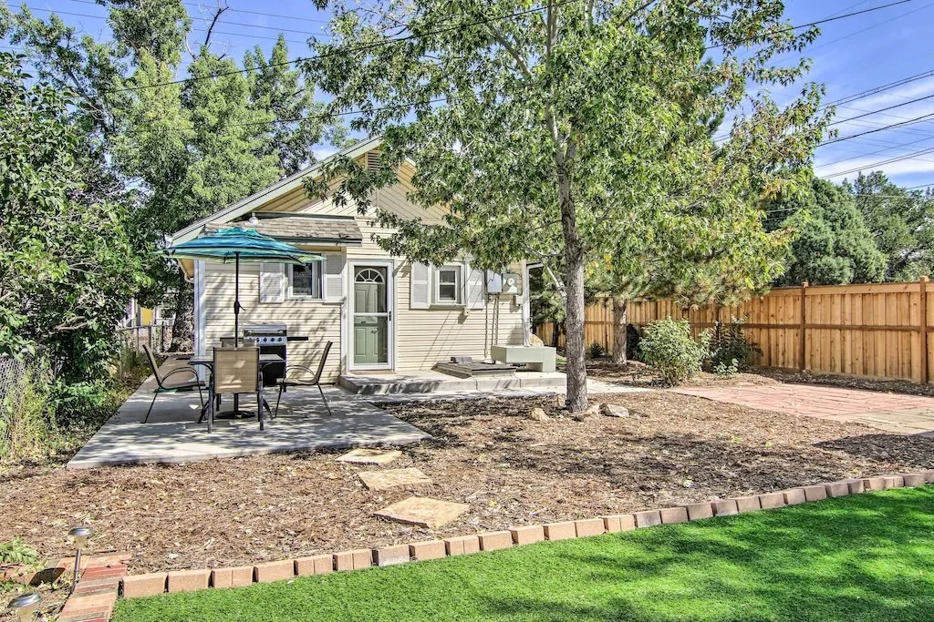
Stay in an adorable Colorado Springs bungalow, within walking distance of downtown Colorado Springs. Or hang out in a modern downtown grotto in the heart of the city. The world is your oyster with so many downtown options to choose.

Relax in this spacious backyard near Garden of the Gods
MIDTOWN - Garden of the Gods
If the plan is to explore more of Colorado Springs after hiking Pikes Peak, staying near Garden of the Gods affords you easy access to this stunning landmark.
Just off I-25, this area is home to UCCS (University of Colorado, Colorado Springs), the fastest growing campus of the UC schools. Park near University Village and take the short hike up Pulpit Rock, watching the sunrise (or sunset).
After a long Pikes Peak hike, treat yourself to a slow afternoon at Garden of the Gods. Here are our favorite picnic spots (Melody's pick in the GOG Visitor Center newsletter).
This is a great place in the city to snag unobstructed views of Pikes Peak.
Grab groceries at Trader Joes and stock up on wine with their newly opened wine store. Or skip cooking all together and eat at one of several local restaurants nearby.

Colorado cozy bungalow minutes from Garden of the Gods
Relax in a 7 bedroom home, the perfect home base for a week’s visit. Hike Pikes Peak trails, explore Garden of the Gods and then come home to a big backyard and reclining chairs. Bliss!
If that seems too big, cozy up in this westside immaculately decorated two bedroom home. Views of the mountains from almost every window as well as a fun fire pit out front.
If you’re traveling solo, consider this updated loft in the heart of Manitou Springs. Located on the top floor, experience unobstructed mountain views and creekside.
North end
The Air Force Academy is located in Colorado Springs' north end. Developers have been busy adding entertainment along the I-25 corridor. Top Golf and Scheels top the list for fun cold weather activities. Watch a movie or go bowling at Summit. Better yet, check out the taxidermy at Bass Pro Shops.
Just a few miles up the road lies Palmer Lake and Palmer Lake Reservoirs, a fun place to SUP and hike around. Throw a round of disc golf and hop over the new pedestrian bridge to RockHouse Ice Cream.
Colorado Springs is home to the USA Olympics
Things to Do in Colorado Springs
Hiking Pikes Peak is just one of many things to do in Colorado Springs. Melody writes a monthly column for the Garden of the Gods Visitor Center with local picks and seasonal tips. A good place to land after your Pikes Peak day, especially if you want a flat, scenic walk to stretch out those tired legs.
It has been exciting growth in the city over the past several years. Revitalization of downtown has added fun restaurants, great shopping, museums and art walks.
Downtown Museums to Up North Golfing
US Olympic and Paralympic Museum
The famous Broadmoor Hotel offers free art tours of General Palmer’s personal art collection. Head to the USA’s highest zoo, Cheyenne Mountain Zoo, to see dozens of giraffes and elephants. Walk among penguins and wallabies, then hang out on Zoo’s famous Sky Ride.
Catch a semi pro soccer game at Weidner Field, the newly built Switchback Stadium. Head to nearby USA Paralympic and Olympic museum, a truly one of a kind interactive experience.
We created three day, four day and seven day Colorado Springs trip planners, highlighting things to do, nearby hikes to take and of course, the best local restaurants to sit and replenish.
CHECK OUT OUR LOCAL’S ONLY COLORADO SPRINGS TRIP PLANNER | 1, 2 OR 5 DAYS IN COLORADO SPRINGS ALL PLANNED FOR YOU!

Colorado Springs Breweries
Colorado craft beer is legendary. With over 400 established breweries in this state, build in some time to see what all the hype is about.
Plan a brewery tour or sample a flight. For all of Colorado Springs craft breweries, check out the Colorado Hikes and Hops Brewery Guide. We tell you where to go, what to sample and interesting facts about each place.
View of Pikes Peak from Palmer Park
Colorado Springs Hikes
Plan some short and easy hikes around Colorado Springs, exploring the depth and breadth of trails this city has to offer.
Purchase a few souvenirs and know that part of the tax you pay (thank you!) keeps these trails open and safe. TOPS (Trails and Open Space) continue to maintain open spaces and parks as Colorado Springs grows.
Related Links:
Take a few short and easy hikes in Colorado Springs.
Don’t miss Red Rock Canyon Open Space, which connects to Manitou Springs and offers some of the best free Pikes Peak views in the city.
Palmer Lake, just north of Colorado Springs, has some of our favorite hiking trails in the area.
Head south and see all the hype around Mueller State Park - it’s magical any season.
Hiking Pikes Peak FAQ
How long does it take to hike Pikes Peak?
Hiking Pikes Peak takes anywhere from 6 to 14 hours round trip, depending on the route, the weather, and your fitness. Barr Trail is the longest at 26 miles round trip and averages 8 to 12 hours. Most hikers start before sunrise to be off the summit by noon.
Do I need a reservation to hike Pikes Peak?
Hikers do not need a reservation to use Barr Trail or Crags Trail. A timed entry reservation is required if you drive Pikes Peak Highway from the Friday of Memorial Day weekend through September 30. The North Slope Recreation Area does not require a summit reservation.
What is the easiest way to summit Pikes Peak?
Devil's Playground Trail is the shortest route at about 5.5 miles round trip, but it requires driving most of the way up Pikes Peak Highway. For a non hiking summit, the Broadmoor Manitou and Pikes Peak Cog Railway is the easiest option year round.
Are the Catamount Reservoirs open in 2026?
Yes. North and South Catamount Reservoirs reopened on May 1, 2026 after a two year closure for dam rehabilitation. Crystal Creek Reservoir remains closed for warranty maintenance work this season. NSRA hours are 9 a.m. to 3 p.m. until May 23, then summer hours begin.
Can you hike Pikes Peak with kids?
Hiking all the way to the Pikes Peak summit with young kids is tough but doable for experienced hiking families. Most local families opt for a section hike on Barr Trail or the newly reopened Catamount Reservoirs loop. Driving up the highway or riding the Cog Railway works well for any age.
What is the best time of year to hike Pikes Peak?
June through early October is the prime window for summiting Pikes Peak. Snow lingers above treeline well into May. The Manitou Incline and lower Barr Trail are passable year round with proper traction and layers.
How much does it cost to drive Pikes Peak Highway?
Pikes Peak Highway entry is $18 per adult, $8 per child (ages 6 to 15), or $65 per carload for up to 5 passengers in 2026. North Slope Recreation Area only visits are $5 per guest plus a $1 parking permit. Children under 16 are free.
Hiking Pikes Peak is a blast. But exploring America’s Mountain other ways is fun too!
