
27 Waterfalls in Colorado You Should Hike To in 2026
Colorado's packed with 27 amazing waterfall hikes for spring through fall—when snowmelt makes them fullest. We've got you covered from easy to challenging. Colorado Springs offers Helen Hunt Falls, Seven Bridges, and St. Mary's Falls. Near Divide, hit Horsethief Falls and Guffey Gorge. Telluride's Bridal Veil Falls towers at 365 feet. Ouray delivers Upper Cascade Falls and Box Canyon. Glenwood Springs features Spouting Rock past Hanging Lake (permit required). Don't miss Browns Creek and Agnes Vaille Falls near Buena Vista. Steamboat's Fish Creek has both lower and upper falls. Rocky Mountain National Park offers Adams Falls and Alberta Falls. Best times: spring/early summer for maximum flow.

Discover all of our favorite waterfalls of Colorado
This page contains affiliate links. If you make a purchase via a link on this page, we make a small commission at absolutely no extra charge to you.
Best Waterfalls in Colorado
The best time to go on hikes in Colorado with waterfalls is spring and early summer, since snowmelt from the mountains fuel the falls, causing them to be at their fullest.
But winter can be a fabulous time for waterfall hiking as well, especially if you prefer less people and listening for soothing trickles under snow covered, icicle adorned falls.
And the fall foliage in aspen groves often found near waterfalls are tantalizing too.

So we’ve rounded up our favorite hikes in Colorado with waterfalls: 13 easy hikes, 11 moderate hikes, and 3 challenging hikes.
From towering waterfalls that crash 365’ below, to cascade hikes that dance underneath wooden bridges along the trail, we’ve grouped these falls by location in spectacular hiking areas in Colorado.
This post is also sprinkled with Waterfall Road Trip Tips and links to more hikes in the Rocky Mountains.
We begin with the coolest trails in our backyard: Colorado Springs waterfall hikes. Click on the location below or scroll down to read about all 27 Waterfall Hikes.
Colorado Waterfall Hikes
Table of Contents
Divide / Florissant / Cripple Creek

Find lots of waterfalls in Colorado Springs
Hikes with Waterfalls in Colorado Springs
Helen Hunt Falls
Easy to moderate // 0.1 - 8 miles // out and back
This wonderful waterfall is easily accessed from a parking lot along North Cheyenne Road making it must-see for all abilities.
There are many options for this waterfall hike.
For more amazing views, hop on the short, more difficult trail just after the bridge and to the left. The trail has a set of stairs built into the side of the canyon that lead to an overlook and another perspective on the waterfall.
Or make this waterfall hike a half day excursion on a longer, moderate Colorado hiking trail by starting from the Lower Columbine Trail. Hike 4 miles up 1,000’ on the Columbine Trail from the bottom of Cheyenne Canyon to Helen Hunt Falls.
Stop to see Helen Hunt Falls on your way up to the trailhead for the next two Colorado Springs hikes below.
Related blog post: Short and Easy Hikes in Colorado Springs

Hiking the Seven Bridges Trail in Colorado Springs
Seven Bridges
Moderate // 3.5 miles // out and back
Seven Bridges is a cascading waterfall enjoyed while crossing seven bridges over the North Cheyenne Creek.
Kids and locals love this winding waterfall hike, so it’s best enjoyed during the week when there are less crowds.
Continue past the seventh bridge for a longer hike that eventually takes you past all the people, through an aspen grove, and up to Loud’s Cabin and the Jones Park area.
St. Mary’s Falls Trail
Moderate // 5.90 miles // out and back
This is a fantastic Colorado waterfall hike in summer, spring and winter. Even when St. Mary’s Falls is covered in snow, you can hear the trickling waterfall in the winter. In winter, be sure to take spikes for traction.
The third waterfall hiking trail in North Cheyenne Canyon mentioned here, this one meanders through the Buffalo Canyon.
Follow a sweet little creek and reach the first waterfall after about 1.7 miles. Just before 3.0 miles, you’ll reach a trail junction.
Go right if you want to keep hiking up to Mount Rosa.
Stay to the left for St. Mary’s Falls and 0.4 miles later you will reach the end of this waterfall hiking trail to see run-off crashing over a granite wall for as much as 300’.
Related Reading:

Seven Falls in Colorado Springs
Seven Falls to Inspiration Point
Moderate // 3 miles // out and back
NOTE: There is a $18 entry fee for adults. Visitors staying at the Broadmoor can take a free shuttle to the Seven Falls. For those not staying there, there is a shuttle available from the Norris Penrose event center off lower Gold Camp Road.
While this waterfall hike might start off feeling like a tourist attraction with its shuttle and paved road, it is well worth the journey and a famous holiday treat.
Once you reach the base of the falls, take the long staircase up to the top of the falls, reading the names and types of waterfalls as you go.
Head to Inspiration Point, a fabulous overlook of Seven Falls.
More fantastic views around Pikes Peak
What better way to experience this city's stunning panoramic vistas than through the exhilarating Seven Falls ziplines? Whether you're an adrenaline junkie seeking adventure or a nature lover looking for unique ways to see the views, here are the best Colorado Springs ziplines*. Soar above treetops, glide across canyons with your crew, and leave with an unforgettable experience under Pikes Peak. *Enter our exclusive reader promo code "COHIKES" and SAVE 10% when you book this or most other Broadmoor outdoor adventures online.
Waterfalls Near Denver
Based in Denver? There are several waterfall hikes about an hour from Denver.
Of those, we have actually done the closest waterfall hike to Denver: Maxwell Falls, found off Hwy 285. You can make this a short or longer hike. For the short hike, begin at the Upper Trailhead and follow the signs to the falls. It’s just under half a mile, one way.
For a longer loop hike, learn about the Cliff Trail Loop.

Map of Colorado Waterfalls: The map below shows you the distance between Colorado Springs, Divide, Cripple Creek, and Guffey.
Reserve a vacation home near Divide Colorado and hit up all of the waterfall hikes above and below!

Horsethief Falls is one of our favorite Colorado waterfalls near Colorado Springs
Waterfalls Near Divide, CO
Horsethief Falls
Moderate // 2.6 miles // out and back
We love this waterfall hike in every season. In fact, this area is popular for hiking and snowshoeing in winter.
Found near Divide, Cripple Creek and Mueller State Park, Horsethief Falls is also a quick day trip from Colorado Springs.
Only the first part of the hike is somewhat steep, deeming this a moderate hike, but then becomes quite easy.
At the base of the falls, the trail becomes more challenging again if you choose to climb along the cascading water. Great place for a picnic.
PRO TIP: For a longer hike, before you go up to Horsethief Falls, opt to turn right at 0.9 miles and hike switchbacks and various terrain for 2 miles up to Pancake Rocks for a splendid view. Then, return down the trail, turning right at the junction for the remaining 0.4 miles to Horsethief Falls for a picnic.

Guffey Falls in Paradise Cove
Guffey Falls in Paradise Cove
Moderate // 1 mile // out and back // $6.00 day use fee per vehicle
Guffey Falls in Guffey Gorge, aka Paradise Cove, sits off the beaten path from Florissant, Divide, and Cripple Creek Colorado.
Visit Guffey Gorge Day-Use Area during the week to avoid tons of people. This waterfall hiking trail along West Four Mile Creek leads visitors through cool rock features, meadows filled with wildflowers and a ponderosa pine forest.
PRO TIP: From mid-May to mid-September, there is a $6 per vehicle day-use fee. There are regulations in place: no alcohol, no overnight camping, no amplified music, no target shooting, no glass, pets must be on a leash, and parking in designated areas only. Visitors are only allowed to use the area between dawn and dusk.
Gingerly climb down the hill to a small swimming hole fed by the cascading waterfall in Guffey Gorge. Keep it dubbed Paradise Cove by leaving no trace and respecting those around you.
Jump at your own risk. Know the risk and know the water depth before you take the plunge.*
*In May 2020, we witnessed a man jump 80 feet from the cliff’s edge above into the small swimming hole and then be pulled from the water. While it wasn’t fatal, he was in severe pain from the jump.

Video of Zapata Falls in a Box Canyon in Colorado — shared with permission from Rad Family Travel
Waterfalls Near Great Sand Dunes National Park
Zapata Falls
Easy // 0.9 miles // out and back
Zapata Falls are fed by South Zapata Creek in the Sangre de Cristos mountains. The waterfall tumbles some 30 feet into a cozy box canyon.
You’ll cross a frigid creek to reach the little box canyon to see Zapata Falls.
This waterfall hike is found seven miles from the entrance to Great Sand Dunes National Park.
In the summer, the falls are a cool treat after trekking the nearby Great Sand Dunes. Winter temps create a giant ice sculpture requiring you to wear crampons to witness the masterpiece.
Here’s everything you need to know about camping at the Great Sand Dunes. Melody’s family enjoyed camping at Pinon Flats, inside the park, while Tanya’s family has camped at Zapata Falls campground, located on BLM Road 5415.
Don’t miss sledding ginormous sand dunes — the Great Sand Dunes are the tallest in North America! Star Dune rises 750 feet from its base to its crest.
NOTE: This area is a Bureau of Land Management (BLM) Special Recreation Management Area.
Map of Colorado Waterfalls: The map below shows you the distance between Zapata Falls and the following three waterfalls below: North Clear Creek Falls, Treasure Falls, and Silver Falls.
North Clear Creek Falls near Creede
Roadside
A worthy detour if you’re headed on to Pagosa Springs (reference map above) from the Great Sand Dunes, discover North Clear Creek Falls off Colorado’s Silver Thread Scenic Byway.
We have been missing out on this one and it’s on our Colorado hiking list!
Located near Creede, this waterfall trek is accessible to everyone. Technically open year around, but usually snowed in between December and April.
PRO TIP: The most accessible portion of the trail for those with wheelchairs and strollers is the paved portion in the first about 0.1 miles when going clockwise.
The North Clear Creek Falls overlook facility is a stop on the Silverthread Scenic Byway right along State Highway 149.
Find a new restroom, picnic tables, ample paved parking for even larger vehicles, trails to the overlook, safety railings, and interpretive signs. It is wheelchair accessible via a trail to a high lookout spot.
PRO TIP: After heavy snows, North Clear Creek Falls becomes a snowmobile trail stop.

Treasure Falls near Pagosa Springs
Waterfalls Near near Pagosa Springs
Treasure Falls
Easy // 0.6 miles // loop
A short waterfall hike in Colorado, the short walk to Treasure Falls is an ideal leg stretcher along Wolf Creek Pass and great for families.
Stop here before you reach Pagosa Springs for a good long soak in amazing Colorado geothermal hot springs.
A short hike, you may have to scramble a bit, but it’s worth it.
In winter, the frozen falls are a treat. Wearing spikes is helpful, as it can get slick on the inclines.
Wolf Creek Pass is a high mountain pass on the Continental Divide, in the San Juan Mountains of Colorado.
Silver Falls
Easy // 0.4 miles // out and back
The scenic, short hike to Silver Falls is worth the bumpy, one-hour journey in a 4X4 with high ground clearance..
Also near Pagosa Springs, this waterfall hike to Silver Falls is on our bucket list.
PRO TIP: Visitors need a capable vehicle with high ground clearance to reach this trailhead. The parking area for Silver Falls is located about 19 miles from Pagosa Springs, 8 miles up along Forest Road 667. Because FR667 is a dirt road that washes out and crosses multiple creeks in spring, when the snowmelt is flowing, many of these creeks rise up and cover the road.

Bridal Veil Falls in Telluride Colorado
Waterfalls Near Telluride, Ouray and Silverton
Bridal Veil Falls
Moderate to challenging // 4.8 miles // out and back
Telluride’s brand new trail to Bridal Veil Falls is no hidden gem, but it’s stunningly worth it.
One of the best waterfall hikes in Colorado, this one is a challenge due to the constant climbing. But hikers report it is better than trekking the OHV road since it’s much more scenic on the new trail’s switchbacks.
You’ll encounter a couple more waterfalls on the new hiking trail. Bridal Veil Falls takes the cake at 365’ tall.
At the trailhead, choose to follow the actual trail, which is through a more forested scenic area and a great workout. Or you can still take the gravel/dirt road that is accessible via car.
We mention this hike in our Romantic Getaways in Colorado in 2026.
CoHH Tip: You can continue your trek on the trail to Blue Lake for 1.9 miles and even further for other destinations.
NOTE: The trail is closed from December to April because of potential avalanches.

Bear Creek Trail takes you to this stunning Colorado waterfall
Bear Creek Trail
Moderate // 5.1 miles // out and back
The Bear Creek Trail starts right from town in Telluride, Colorado.
A popular trail in Uncompahgre National Forest, this waterfall hike leads to fantastic views of the 80 foot cascade of upper Bear Creek Falls.
This sweet hiking and mountain biking trail meanders through the 325 acre Bear Creek Preserve, full of aspen and pine groves. Bear Creek is a public open space.
Avid hikers may want to extend their adventure up the cliffs of Bear Creek Canyon by hopping on the Wasatch Trail.
CoHH PRO TIP: Park in the public parking in Mountain Village and take the free gondola into downtown Telluride. More fabulous views!
Map of Colorado Waterfalls: See the map below to get your bearings for waterfall hikes near Telluride, Ouray and Silverton. Again we think staying near Ouray is a great place to hike yourself for hiking in and around the Mt. Sneffels area.

The view from Upper Cascade Falls
Upper Cascade Falls to Chief Ouray Mine
Hard // 4.3 miles// out and back
Fuel up at breakfast and head out early on one of our favorite hikes to a Colorado waterfall just on the outskirts of Ouray in the San Juan Mountains.
The steep climb to see the secluded Upper Cascade Falls, followed by the Chief Ouray Mine pays off in fantastic views of Ouray and an up close look at an old mine bunk house.
Hop on the trail from Ouray Amphitheatre Campground. Best with older kids, since a few sections are a bit precarious, this one is a gem!
Lower Cascade Falls in Cascade Falls Park can be easily accessed from town.
We also feature this hike in our list of 17 Unmissable Colorado Hikes.
Related Blog Post: Million Dollar Highway and Ouray Hikes
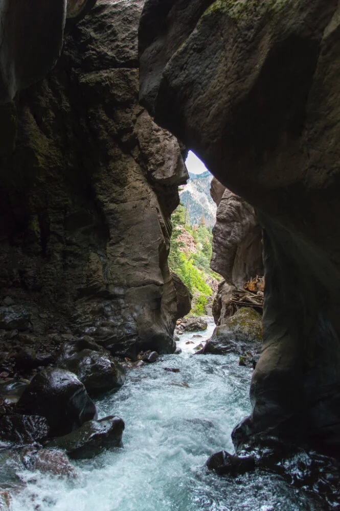
Box Canyon Waterfall Park in Ouray
Box Canyon Waterfall Park
Easy // < 1 mile // combination of loops and out and back
This 285’ tall waterfall inside a box canyon is a hit with all ages and abilities.
Ogle Ouray’s Box Canyon Falls from above and below inside a canyon encased by 100 foot tall walls.
There are three short waterfall hiking trails you can take in the park: Falls Trail, High Bridge Trail, and the Native Plant Loop.
PRO TIP: This waterfall park has an entrance fee:
$5 | 4- 17 Years Old
$7 | 18 - 62 Years Old
$6 | 62 - 74 Years Old
Free |. 75 + and 3 and under
Baby Bathtubs
Easy // 0.6 miles // out and back
This waterfall hike is part of a longer, more challenging Colorado hiking trail, the Ouray Perimeter Trail.
Baby Bathtubs is found just off Amphitheater Campground road and is a glorious way to cool off after an outdoor adventure in the San Juan Mountains.

Baby Bathtubs in Ouray showcases cascading waterfalls
Explore beautiful rock formations and colors, small pools of water, several small cascading falls, and a mini slot canyon.
You may even spy some folks canyoneering.
Ouray is a great place to base yourself in this part of the San Juan Mountains, placing you between Silverton and Telluride.
Related Blog Post: Million Dollar Highway and Ouray Hikes
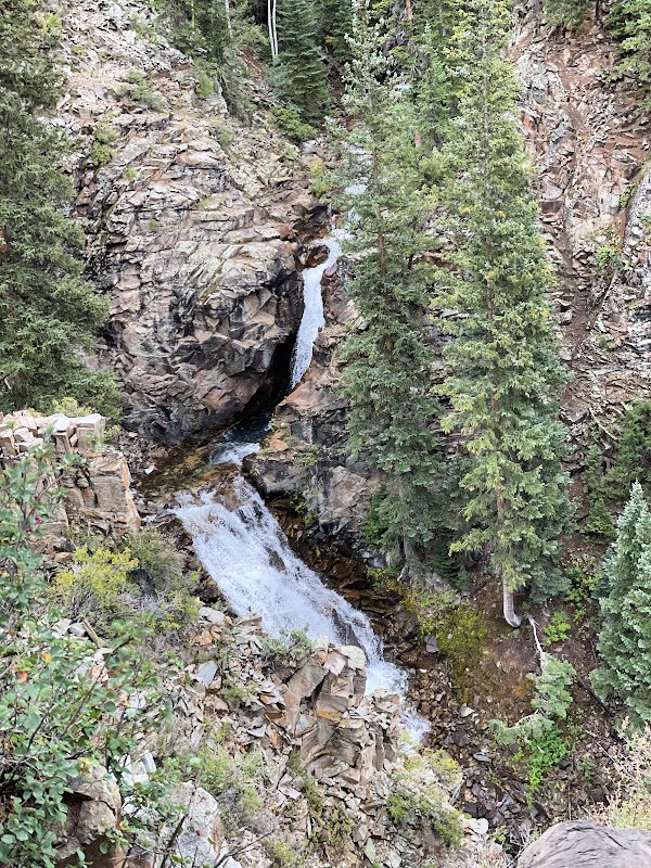
South Mineral Creek Falls
Easy // < 1 mile // out and back
South Mineral Creek Falls is a colorful two-tiered waterfall that drops a total of approximately 55 feet —the upper tier falling into a large blue pool and the lower tier dropping another 20 feet into a narrow gorge further downstream.
Hop on this waterfall hike from the scenic campground by the same name in the San Juan National Forest. In summer, it’s refreshingly easy to get wet from the waterfall!
South Mineral Campground, is one of the most popular campgrounds in the San Juan National Forest.
Enjoy the color-contrasting reds and grays of the area’s peaks. For a longer hike, hop on Ice Lake Trail, a strenuous but popular Colorado hiking trail.
On our list next time we head to Ouray - Silverton area, learn about South Mineral Creek Falls.
Download the FREEBIE: 27 Waterfall Hikes in Colorado (PDF) and Colorado hiking trails and tips. Map of Colorado Waterfalls included. Just sign up below and you’ll immediately see a link.

Spouting Rock is a fantastic Colorado waterfall, just up the trail from famous Hanging Lake
Waterfalls Near Glenwood Springs
Spouting Rock
Moderate // 3.3 miles // out and back // permit required
A gorgeous, fun waterfall hike just 200 yards past the iconic turquoise waters of Hanging Lake in Glenwood Springs is one of the most missed waterfalls in Colorado!
Many hikers don’t take the time to head up to Spouting Rock after they’ve hung out around iconic Hanging Lake.
The trailhead is the same as the one for Hanging Lake, at a rest stop just off I-70. The parking area is adjacent to the Colorado River. This steep hike has many large rocks and steps; plan on 2-4 hours for this hike.
Don't forget to follow the signs once at Hanging Lake to head to Spouting Rock.
Please read all information about the Hanging Lake Trail before purchasing your permit. Again, a permit is required for this hike too, as this is just past the famous Hanging Lake.

Grizzly Creek Trail
Grizzly Creek Trail
Hard // 7.8 miles // out and back
A fun waterfall hike with kids, this one is full of picnic spots and fishing holes at the beginning two miles.
PRO TIP: As of Spring 2024, this trail is open, but only the first two miles are accessible. The rest of the trail is still closed for reforestation. It is still a worthwhile hike as the first two miles are beautiful as they follow the mountain creek.
Boasting picture perfect scenery, Grizzly Creek is a Colorado hiking trail laced with wildflowers and playful pitstops and plenty of shaded sections.
You’ll follow the cascading falls closely the first 2.4 miles before reaching the burn scar, fascinating in and of itself.
Serious elevation gain, but over friendly terrain.
Related blog post: Glenwood Canyon Hikes and Hot Springs
Jessie Weaver Trail
Moderate // 8-9 miles // out and back
Cascading waterfalls spur you on this waterfall hike on as you climb higher along No Name Creek through stunning No Name Canyon.
After you cross the walking bridge at 3 miles in, you will enter a burn scar area that is coming back to life. The Grizzly Fire took its toll on this area.
PRO TIP: Be aware of increased risk from hazard trees, falling rocks, stump holes, and flash flooding resulting from the 2020 Grizzly Creek Fire.
Rifle Falls via Coyote and Squirrel Loop
Easy // 1.8 miles // loop // $9 day fee per vehicle
This year round 70’ waterfall hike in Colorado dishes out the eye candy in winter just as much as in early summer.
Great fun awaits for the whole family in Rifle Falls State Park with one of the best Colorado waterfall hikes that’s just 45 minutes west of Glenwood Springs.
Located in the lush green wilderness of Colorado's Western Slope, Rifle Falls State Park will surprise guests with its tropical landscape in the midst of an otherwise arid environment.
Bring a headlamp for cool hikes to the limestone caves in the park. In winter, bring spikes, as the trail can be quite slippery.
Campers come to Rifle Falls Park for RV camping and benefit from having the falls all to themselves during off-peak hours.
PRO TIP: Rifle Falls State Park charges a fee to enter. Entrance fees are $9/vehicle or $4/person for any non-vehicle entry. An annual pass is also available for $80
RELATED: 15 Scenic Colorado Campgrounds We Absolutely Love

Rent an RV so you can hike to as many Colorado waterfalls as possible
Save $50 off your next Outdoorsy RV Rental
Lots of RV Rentals near Rifle Falls State Park.
Use our exclusive promo code “COHH50” and save $50 OFF your next RV rental.
Own an RV? Wanna make up to $50,000 this next year?
Best side hustle yet! Rent your RV when you’re not using it. Folks are always looking for RVs to rent, especially Class B and Class C RVs.
Map of Colorado Waterfalls: The map below shows how close the four hikes mentioned above are to Glenwood Springs and to each other.

Browns Creek Waterfall near Buena Vista and Salida Colorado
Waterfalls Near Buena Vista and Salida
Browns Creek Waterfall Trail
Moderate // 6.2 miles // out and back
Nearly equidistant from both Buena and Salida, this Colorado waterfall hike takes you along various terrain with a sandy start, followed by pine and aspen forests and a meadow crossing before reaching Browns Creek Waterfall.
Small log bridges cross Browns Creek here and there on this hike that’s accessible year round. In winter, prepare to wear spikes and gaiters for extra traction, safety, and protection.
Keep your eyes peeled for small signs directing your towards this Colorado waterfall.
In summer, begin early in the morning to avoid the hot sun in the summer since the hiking trail is exposed quite a bit.
Continue hiking to Browns Lake and log 12 miles round trip for a more challenging hike.
In the winter, you’ll definitely want to bring spikes and poles, and sometimes snow shoes are required.
We also feature this hike in our list of 17 Unmissable Colorado Hikes.
Related blog posts: More Colorado Hiking in Buena Vista and Salida

Agnes Vaille Falls
Agnes Vaille Falls
Moderate // 1.2 miles // out and back or loop
An absolute favorite waterfall near Salida and Buena Vista, we’ve taken friends and family to Agnes Vaille Falls numerous times, in all seasons. Be sure to have microspikes for traction in winter.
A short but steep hike, do the loop version for varying views.
This Colorado waterfall hike is set in the Chalk Cliffs on the southeastern side of Mount Princeton, just past Mount Princeton Hot Springs — one of the best hot springs resorts in Colorado.
Stay in a magnificent mountain home along the Chalk Cliffs and enjoy hiking, rafting, biking, fishing and more.
Or rent an RV near Buena Vista or Salida so you can easily move around between hikes in this fabulous part of Colorado.
Once you’ve finished waterfall hiking around Buena Vista and Salida, head over to Crested Butte for Judd Falls and 11 Stunning Hikes in Crested Butte.
Map of Colorado Waterfalls: Get your bearings between Buena Vista, Salida, and Crested Butte with the map below.
Judd Falls in Crested Butte Colorado
Judd Falls Near Crested Butte
Easy // 2.2 miles // out and back
This short waterfall hike takes you to an overview of the magnificent Judd Falls.
The hike begins at 9600’ and the trail is open June - October.
The best part is you can add on Copper Creek Trail #983, leading you up to hike the East Maroon Pass.
We came upon Judd Falls at the end of our two day trek hiking Crested Butte to Aspen and then back again the next day.
HEADS UP! Wolves are being reintroduced in this area and one hiker reported encountering a wolf on the trail, from a distance. Think twice before bringing your dogs on the trail. Always keep them on leash.
CoHH Tip: 4WD is very helpful to reach the Judd Falls / Copper Creek Trailhead parking lot with bathroom, found on the right side of Gothic Road (317), just after the little town of Gothic. You can drive your car up another 1/2 mile to an upper parking lot to be even closer to the trailhead.
Related Blog Posts: Hiking Crested Butte to Aspen, Other Hikes Around Maroon Bells

Lower Fish Creek Falls is one of the most popular Colorado waterfalls
Lower and Upper Fish Creek Falls in Steamboat
Lower Falls: Easy // 1 mile // out and back
Upper Falls: Hard // 4.7 miles // out and back $5 parking fee
Open year round 6 am to 10 pm
This challenging waterfall hike in Colorado is a two-for-one and can be done all year long.
While Lower Fish Creek Falls is the more impressive 283’ waterfall, the hike to Upper Fish Creek Falls is for those who like a challenging hike ending at a second scenic waterfall.
The trail becomes more technical along the switchbacks leading to Upper Fish Creek Falls, but you’ll find plenty of shade in the aspens and pine trees surrounding sections of the trail.
CoHH Tip: A stroller and wheelchair friendly path leads to a nice overlook of Lower Fish Creek Falls.
One of the most popular waterfalls in Colorado, aim for hiking here mid-week if you can.
Related blog posts: Steamboat Springs Hot Springs and Hikes

Upper Fish Creek Falls
Waterfalls in Rocky Mountain National Park
Adams Falls
Easy // 0.8 miles // lollipop // national park entry fee
Rocky Mountain waterfalls are tough to match.
The trailhead for this lovely Colorado waterfall hike is up the road from Grand Lake and Grand Avenue, where you’ll find ice cream and goodies after the trail.
Kids love the hike to Adams Falls — kick off your shoes and get your feet wet. Late spring and early summer provide the best waterfall views. Wear spikes if hiking here in winter.
You’ll have the option to continue hiking past Adams Falls for more scenic views. Don’t be surprised if you encounter backpackers coming out of the wilderness.
Even in winter, the frozen falls are a sight, but you’ll likely need spikes on the trail.
Rocky Mountain National Park charges a fee to enter. You can also purchase a park-specific annual pass. For more information, please see https://www.nps.gov/romo/planyourvisit/fees.htm

Alberta Falls - Rocky Mountain National Park waterfall hike
Alberta Falls
Easy // 1.6 miles // out and back // national park entry fee
We suggest starting early on this hike to avoid crowds and get the best pictures.
This route begins in Rocky Mountain National Park at the Glacier Gorge Junction Trailhead but could easily be done from the Bear Lake Trailhead.
As you hike, take in the scenery of the beautiful pine forest and enjoy Alberta Falls, which are located at the 3/4 mile mark.
This is a great stop for kids to explore the waterfalls as well as cool off.
Wear spikes if hiking here in winter.
Find more waterfalls in Rocky Mountain National Park .
This waterproof, tear-resistant map includes trails, trailheads, points of interest, campgrounds, lakes and more.
Rocky Mountain National Park charges a fee to enter. You can also purchase a park-specific annual pass. For more information, please see https://www.nps.gov/romo/planyourvisit/fees.htm
Download your free list of 27 Waterfall Hikes in Colorado. Map of Colorado Waterfalls included.
Tips for Colorado Waterfall Hiking Trails
Wear the right footwear for hiking to waterfalls in Colorado. Many of the above trails will have large rocks and you may be crossing small streams and more. Here’s how to choose the right hiking footwear.
Make sure the trail is open, especially in winter.
Check to see if there is a fee to enter; bring cash just in case.
Find out if spikes / crampons and trekking poles would be helpful, especially in winter. We suggest always carrying spikes in your pack when hiking in winter.
Wear gaiters to keep out snow, water, mud, dirt, little sticks, scree, and pine needles. We love Dirty Girl gaiters, available in different heights.
Pack the right daypack for your hike, complete with water, snacks, first aid kit, and layers. We love the Osprey Sirrus Hiking Daypack for women, or the Stratos version for men, for carrying water, layers, and snacks on cool Colorado day hikes
YOU MAY ALSO WANT TO READ:
Unmissable Colorado Hikes - Our Top Trails We Love Exploring
Paddleboarding in Colorado: The Best Spots in the State